Sold2015A. M. Perrot. Map of United States. 1837.Print of hand colored steel engraving titled Etats-Unis“.Author A. M. Perrot.Engraved by unknown.From Dictionnaire universel Geographie moderne, description physique, politique et historique de tousSee Sold Price
Sold2015Victor Lavasseur. Map of United States. 1830.Print of hand colored steel engraving titled Etats Unis“.Author Victor Lavasseur.Engraved by unknown.From Atlas classique universel de Geographie anciene et moderne“ by Victor Levasseur. Paris. 18See Sold Price
Sold2019Group of Three Maps, consiting of Jules RenouardGroup of Three Maps, consiting of Jules Renouard (1798-1844, Paris)," Etats-Unis," 1826, hand colored, H. - 8 1/4 in., W. - 16 1/2 in.; Unknown, "A Map of the Vicounty of Paris. Drawn from a great numSee Sold Price
Sold2021Antique French Map of United States- Etats-Unis De L'Amerique Septentrionale Avec Les Isles Royale, De Terre Neuve, De St. Jean, L'Acadie &c.; Hand-colored; Ches Boudet Imprimeur du Roi; Paris; undated (circa 1785). One of the early maSee Sold Price
Sold2022(CIVIL WAR.) Jean-Rodolphe Mayer. Nouvelle Carte des Etats-Unis de l'Amerique du Nord… 2de(CIVIL WAR.) Jean-Rodolphe Mayer. Nouvelle Carte des Etats-Unis de l'Amerique du Nord… 2de Edition. Large hand-colored lithographed map of the United States with a keyed reference table numberinSee Sold Price
Sold2016French map of U.S. derived from MelishHeading: Author: Buchon, Jean Alexandre Title: Etats-Unis d'Amerique Place Published: Paris Publisher: Date Published: 1825 Description: Copper-engraved map, hand-colored.See Sold Price
Sold2018Indians of Florida 1563 - PicheEtats Unis - Estados Unidos [United States of America] - Piche - Pesca. Florida 1563 Artist: Vernier - Lebas Print Type: Hand Colored EngraviSee Sold Price
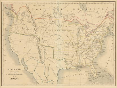
Sold2023EUSTACHE-HYACINTHE LANGLOIS (1777-1837) A MEXICAN TEXAS MAP, "Etats Unis et Partie de L'AméEUSTACHE-HYACINTHE LANGLOIS (1777-1837) A MEXICAN TEXAS MAP, "Etats Unis et Partie de L'Amérique Anglaise et du Mexique," PARIS, CIRCA 1830, lithograph on cream wove paper with hand color, probabSee Sold Price
Sold2022(ASIA.) Jean Janvier. l'Asie Divisee en ses Princepaux Etats.(ASIA.) Jean Janvier. l'Asie Divisee en ses Princepaux Etats. Large hand-colored double-page engraved map of the Asian continent, Indonesia, and a remarkably distorted island(?) of New Guinea. 21½See Sold Price
Sold2022(EASTERN EUROPE.) L. Sagansan. Carte des Voies de Communication de la Russie d'Europe et des Etats(EASTERN EUROPE.) L. Sagansan. Carte des Voies de Communication de la Russie d'Europe et des Etats Voisins. Large hand-colored lithographed map of central and eastern Europe. 41¾x39 inches overalSee Sold Price
Sold2019Les Etats Unis de I'Amérique Septentrionale, partieTITLE/CONTENT OF MAP: 'Les Etats Unis de I'Amérique Septentrionale, partie Occidentale [The United States of North America, western part]' The top image on the right hand side shows the entire map. TSee Sold Price
Sold20221806-Dated LAmerique Western Hemisphere MapHistoric Maps 1806 Western Hemisphere Map "L'Amerique divifee Pars Grands Etats Janvier C.F. Delamarche, Robert deVaugondy" 1806-Dated Hand-Colored Engraved Copper Plate Map of the Western HemisphereSee Sold Price
Sold202119th Century Map of MemphisPLAN DE LA VILLE DE MEMPHIS (ETATS-UNIS) 40,000 HABITANTS pen and ink with watercolor hand drawn drainage system map, circa 1870. Depicts a grid street plan of the city of Memphis with labeled streetSee Sold Price
Sold2022c 1760 Northern Colonies French + Indian War MapHistoric Maps Louisiana & Florida French & Indian War Era Map c. 1760 c. 1760 French & Indian War Era, Hand-Colored Map of Pennsylvania and New England titled, "Carte de la Partie Nord, Des Etats UnisSee Sold Price
Sold2023Jean Janvier - 18th Century Map of the AmericasJean Janvier (fl. 1746-1776), L'Amerique Septentrionale divisee en ses principaux Etats…, Paris, 1762, engraving on laid paper with hand colored highlights, sight 14-1/8 x 19-3/4 in.; wood framSee Sold Price
Sold2023Selling a later version of the famous Evans – Jeffreys hand colored map of 1755, this versionSelling a later version of the famous Evans – Jeffreys hand colored map of 1755, this version published in Paris in 1787 titled “Carte Generale des Etats de Virginie, Maryland, Delaware,See Sold Price
Sold2022CHARLES FURNE (1794-1859) A MAP OF THE U.S. AND MEXICO,CHARLES FURNE (1794-1859) A MAP OF THE U.S. AND MEXICO, "États-Unis & Méxique.," PARIS, CIRCA 1851, lithograph with hand coloring on paper, plate No. 25, Lemercier, lithographer at rue de SeSee Sold Price
Sold2023JEAN DENIS JANVIER (FRENCH, FL, 1746-1779) MAP OF NORTH AMERICAJEAN DENIS JANVIER (FRENCH, FL, 1746-1779) MAP OF NORTH AMERICA, hand-colored copper-plate engraving, titled L'Amerique Septentrionale divisee en ses principaux Etats, Paris, 1See Sold Price
Sold2018Engraved map of Canada and United StatesCarte de la Region Orientale des Etats-Unis et de la dominion du Canada, 19th century, engraved map with hand coloring, designed by A. Brue, overall (with frame): 19.5"h x 25"wSee Sold Price
Sold2023Jean Janvier - 18th Century Map of the AmericasJean Janvier (fl. 1746 - 1776), L'Amerique divisee Par Grands Etats..., Paris, 1783, engraving on laid paper with hand colored highlights, sight 13 x 18-1/2 in.; wood frame, 21-3/8 x 27 in. ProvenanceSee Sold Price
Sold2022Delamarche - Three Maps of the AmericasCharles Francois Delamarche (1740-1817), including: Amerique Septentrionale; Amerique Meridionale; Carte Des Etats-Unis; published in Paris, each in two sheets, engravings on laid paper with hand coloSee Sold Price
Sold20184 Maps: Central Europe. Homann, Thomson , de Witt.[Homann/Thomson] 4 Maps. Hand colored. ++ L’Allemagne, distinguee en ses Cercles & subdivisee in ses Etats, contenant son Etendue presente… Mr. Schatz A. 1741 avec Privilege Imperial. Title aboveSee Sold Price
Sold2016ANTIQUE NEW-FRANCE HAND COLORED MAPANTIQUE NEW-FRANCE HAND COLORED MAP, H 27 1/2" IMAGE, W 20 1/2":Framed, measures H.30" x 23" overall.See Sold Price
Sold2024Matthaus Merian 1627 Antique Hand Colored Map "Virginia" from Theodore de Bry's "Grand Voyages" #2Antique 1627 hand-colored map of Virginia by Matthaus Merian after John Smith's 1612 map, from Theodore de Bry's "Grand Voyages". Good condition overall, with age-appropriate wear, repairs (see photosSee Sold Price
May 18Blackstone Valley Auctions & Estates LLCRevolutionary Era War Map of the Attack on Ft. Moultrie.$100
1 day LeftTremont AuctionsJohn Speed and Francis Lamb "Map of New England and New York", ca. 1676. Hand colored engraved map$900(3 bids)
9 hrs LeftTrillium Antique Prints & Rare BooksMitchell's A New Universal Atlas.. - Volume with 73 Maps$1,000(1 bid)
May 14Fleischer's Auctions1755 Map Partie de l'Amerique Septentrionale, qui comprend Le Cours de L'Ohio...$200(3 bids)


![Indians of Florida 1563 - Piche: Etats Unis - Estados Unidos [United States of America] - Piche - Pesca. Florida 1563 Artist: Vernier - Lebas Print Type: Hand Colored Engravi](https://p1.liveauctioneers.com/5614/124985/63596915_1_x.jpg?height=310&quality=70&version=1531600922)


![Les Etats Unis de I'Amérique Septentrionale, partie: TITLE/CONTENT OF MAP: 'Les Etats Unis de I'Amérique Septentrionale, partie Occidentale [The United States of North America, western part]' The top image on the right hand side shows the entire map. T](https://p1.liveauctioneers.com/5584/147595/74587359_1_x.jpg?height=310&quality=70&version=1565730371)


![4 Maps: Central Europe. Homann, Thomson , de Witt.: [Homann/Thomson] 4 Maps. Hand colored. ++ L’Allemagne, distinguee en ses Cercles & subdivisee in ses Etats, contenant son Etendue presente… Mr. Schatz A. 1741 avec Privilege Imperial. Title above](https://p1.liveauctioneers.com/179/117971/60557753_1_x.jpg?height=310&quality=70&version=1520636872)


