Sold2015Hennepin's account of New World 1698Heading: Author: Hennepin, Louis Title: A New Discovery of a Vast Country in America, Extending above Four Thousand Miles, Between New France and New Mexico; with a Description of the Great Lakes, CaSee Sold Price
Sold20211854 America COLUMBUS Voyages Cortez Peru Spain Vikings1854 America COLUMBUS Voyages Cortez Peru Spain Vikings Pirates Witchcraft + Samuel Goodrichs Pictorial History of America is an impressive and thorough account of history of the new world focusing onSee Sold Price
Sold20231799 United States MAP 1ed Rochefoucauld Voyages in Canada INDIANS Saratoga1799 United States MAP 1ed Rochefoucauld Voyages in Canada INDIANS Saratoga La Rochefoucauld-Liancourts account of his voyage to the New World is an important perspective on America and Canada prior tSee Sold Price
Sold2021Map of Turky, Arabia and Persia. Corrected from the[In A New general atlas : containing a geographical and historical account of all the empires, kingdoms and other dominions of the world, by John Senex][London, 1721]47 cm x 57 cm Watermarked paper. OSee Sold Price
Sold20221620 New World Document! Ship's Expense and Credit Log1620 New World Document! Ship's Expense and Credit Log from a Voyage to Newfoundland 1p, measuring 12.5" x 8", No place, dated November 20, 1620. A detailed account and expense list for a voyage takenSee Sold Price
Sold20211870 New World Compared to Old America Great Britain1870 New World Compared to Old America Great Britain France History Townsend George Townsend’s “New World Compared with the Old” is a 19th-century historical account America, France, and Great BSee Sold Price
Sold20241887 Christopher Columbus 1ed Adventures & Voyages History New World Discovery1887 Christopher Columbus 1ed Adventures & Voyages History New World Discovery “The Adventures of Columbus” by Frances A. Humphrey is an illustrated historical account aimed at young readers tSee Sold Price
Sold20151939 New York World's Fair Original Scrapbook. A first1939 New York World's Fair Original Scrapbook. A first hand account with photos and paper: A really rare find. this is a over stuffed original scrapbook filled with photos, brochures, tickets, and othSee Sold Price
Sold2023[CHANG AND ENG] An Account of Chang and Eng, the World Reno...[CHANG AND ENG] Life of the Siamese Twins. New York: Published by T.W. Strong, 1853. Buff pictorial wrappers bearing a portrait of the twins with two of their children. Engraved frontispiece, text See Sold Price
Sold2022Capa's photographic account of World War 2Heading: Author: Capa, Robert Title: Slightly Out of Focus Place Published: New York Publisher:Henry Holt and Company Date Published: 1947 Description: Illustrated profuselSee Sold Price
Sold20231848 HISTORICAL & GEOGRAPHICAL ACCOUNT OF PROVINCE & COUNTRY of PA & NJ antiqueAn Historical and Geographical Account of the Province and Country of Pensilvania And of West-New-Jersey in America ; with a Map of Both Countries by Thomas, Gabriel Facsimile of the 1698 edition reprSee Sold Price
Sold20167 Vols: Plate/map books, 1700s.[18th Century Plate/Map Books] 6 Titles (7 Vols). ++ A NEW GEOGRAPHICAL DICTONARY, CONTAINING A FULL AND ACCURATE ACCOUNT OF THE SEVERAL PARTS OF THE KNOWN WORLD… 2 Vols. Lon: J. Coote, 1759-60. FolSee Sold Price
Sold20201684 Pas kaart Van de Caribes Tusschen I. Barbados en IThis is an authentic antique map of the Lesser Antilles by Johannes Van Keulen. The map was published in Amsterdam in the year 1684. This is an impressive hand colored example of Van Keulen’s nSee Sold Price
Sold20211613 America sive India Nova ad magnae GerardiBy: Michael MercatorDate: 1613 / DuisbergDimensions: 16 x 19.5 inches (40.7 x 49.5 cm)This is an authentic antique map of the Western Hemisphere by Michael Mercator. The map is based on Rumold MercatoSee Sold Price
Sold20211627 Carte de l'Amerique Corrigee, et Augmentee, dessusBy: Bertius/TavernierDate: 1627 (circa)Dimensions: 20 x 15.25 inches (50.75 x 38.5 cm)According to Burden, "This rare map is one of a set of the four known continents that Melchior Tavernier had engraSee Sold Price
Sold2020The Western Coast of Louisiana... Coast of New LeonA first state example of the earliest map to focus on the coast of Texas, recognized as the New Kingdom of Leon” This landmark map of the Texas coast presents the area as the Kingdom of Leon,” andSee Sold Price
Sold20211794 A New and General Map of the Middle DominionsBy: Lewis Evans published by Laurie & Whittle Date: 1794 (Published) London Dimensions: 18.75 x 25.6 inches (47.6 x 65.02 cm) This is a fine old color example of the Laurie & Whittle edition of LewisSee Sold Price
Sold20211661/1707 Corporum Coelestium MagnitudinesBy: Andreas Cellarius - pub. by Valk & SchenkDate: 1661 / 1708 (published) AmsterdamDimensions: 16 x 19.5 inches (40.5 x 45.5 cm)Beautiful celestial map by the famous cosmographer Andreas Cellarius, sSee Sold Price
Sold20211658 Nova et Accurata Iaponiae, Terrae Esonis, acBy: Johannes JanssonDate: 1658 (published) AmsterdamDimensions: 18 x 22 inches (45.7 x 55.9 cm)This is an authentic antique map of Japan and Korea, showing portions of China, Landt van Eso and CompagnSee Sold Price
Sold2020Asia IV Tab.This is an early and scarce map of present day Saudi Arabia, Qatar, United Arab Emirates, Yemen, and Oman. Only the first (1578) and second (1584) editions of the atlas were published during Gerard MeSee Sold Price
Sold20211584 Asia VI Tab.By: Mercator / PtolemyDate: 1584 (circa) Amsterdam.Dimensions: 19 x 13 inches (48.25 x 33 cm)This is an early and scarce map of present day Saudi Arabia, Qatar, United Arab Emirates, Yemen, and Oman.See Sold Price
Sold20211588 Africae Tabula NovaBy: Abraham OrteliusDate: 1588 (published) AntwerpDimensions: 14.5 x 18 inches (36.83 x 45.72 cm)This is an authentic antique map of Africa was published by Abraham Ortellius in 1588. It was taken froSee Sold Price
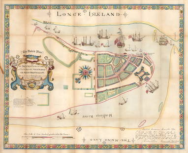
Sold20211664 / 1859 "The Duke's Plan" A Description ofBy: original cartographer unknown / Reissue by: David Thomas Valentine / Engraved by: George HaywardDate: original manuscript 1664 / Reissue 1859 (Published) New YorkDimensions: 21.75 x 27.25 inches (See Sold Price
Sold2020Kaarte van de Golf van Mexico en het Zuyd-America waarBy: Daniel de la FeuilleDate: 1747 (Published) AmsterdamDimensions: 19.5 x 22.5 inches (50 cm x 57 cm)This is an extremely rare and highly unusual map by the cartographer Daniel de la Feuille, and engSee Sold Price
Freeman's | HindmanSTATE DEPARTMENT | A group of 6 FIRST EDITIONS, 2 INSCRIBED TO ALBRIGHT.$150(3 bids)
May 16Zikorn Arts & History ObjectsAndré Maurois, Inscribed: Tragedy in France, 1940 First Edition$150
May 11Auction WallstreetLladro Porcelain Sculpture ''The New World''. Numbered #470, 1486 on the bottom. AW$400
4 days LeftJasper52Spanish New World Empire 1748, Viceroyalty of Peru, Potosi, Bolivia. Silver cob 4 reales$500
6 days LeftForum AuctionsHuxley (Aldous) Brave New World, first edition, 1932 & another first edition by Malcolm Lowry (2)£75
May 11Auction WallstreetVintage Schmid Aladdin Music Box Jasmine 1994 Vintage A Whole New World Spins$50


![Map of Turky, Arabia and Persia. Corrected from the: [In A New general atlas : containing a geographical and historical account of all the empires, kingdoms and other dominions of the world, by John Senex][London, 1721]47 cm x 57 cm Watermarked paper. O](https://p1.liveauctioneers.com/6940/190006/95714289_1_x.jpg?height=310&quality=70&version=1609447005)


![[CHANG AND ENG] An Account of Chang and Eng, the World Reno...: [CHANG AND ENG] Life of the Siamese Twins. New York: Published by T.W. Strong, 1853. Buff pictorial wrappers bearing a portrait of the twins with two of their children. Engraved frontispiece, text ](https://p1.liveauctioneers.com/928/274472/144311140_1_x.jpg?height=310&quality=70&version=1673893579)


![7 Vols: Plate/map books, 1700s.: [18th Century Plate/Map Books] 6 Titles (7 Vols). ++ A NEW GEOGRAPHICAL DICTONARY, CONTAINING A FULL AND ACCURATE ACCOUNT OF THE SEVERAL PARTS OF THE KNOWN WORLD… 2 Vols. Lon: J. Coote, 1759-60. Fol](https://p1.liveauctioneers.com/179/93063/47518669_1_x.jpg?height=310&quality=70&version=1473187115)