Sold2022J. H. Colton’s Topographical Map of Louisiana, Mississippi and Alabama. & partsTitle: J. H. Coltonâ€â„¢s Topographical Map of Louisiana, Mississippi and Alabama. & parts of Adjoining States. Publisher: Joseph Hutchins Colton Height: 19 Width: 31 Rare Colton large forSee Sold Price
Sold2022[MAPS & ATLASES]. COLTON, J.H. (1800-1893). Colton's New Topographical Map of The States Of[MAPS & ATLASES]. COLTON, J.H. (1800-1893). Colton's New Topographical Map of The States Of Virginia, Maryland and Delaware, Showing Also Eastern Tennessee & Parts Of Other Adjoining States. New York:See Sold Price
Sold2018SDUK Louisiana, Mississippi and part of Alabama“North America/ Sheet XIII/ Parts of Louisiana, Arkansas, Mississippi, Alabama & Florida.” London: SDUK & Baldwin & Gradock, 1833. 12 1/4 x 15 1/2. Engraving by J. & C. Walker. Original outline coSee Sold Price
Sold2019US GULF COAST Louisiana Mississippi Alabama FloridaTITLE/CONTENT OF MAP: 'NORTH AMERICA, SHEET XIII., Parts of Louisiana, Arkansas, Mississippi, Alabama, Florida' DATE PRINTED: 1874 IMAGE SIZE: Approx 32.5 x 42.0cm, 12.75 x 16.5 inches (Large) TYPE: ASee Sold Price
Sold2017SDUK: Antique Map of US Gulf Coast, 1846Title/Content of Map: 'NORTH AMERICA, SHEET XIII., Parts of Louisiana, Arkansas, Mississippi, Alabama & Florida' Native American settlements are named on the map west of the Mississippi, some marked wSee Sold Price
Sold20231835 Mitchell Map of Louisiana, Mississippi and Alabama -- Map of the States of Louisiana,Title: 1835 Mitchell Map of Louisiana, Mississippi and Alabama -- Map of the States of Louisiana, Mississippi & Alabama Cartographer: S Mitchell Year / Place: 1835, Philadelphia Map Dimension (in.): 1See Sold Price
Sold2019J. H. Colton, "Map of Louisiana," 1886, hand colored,J. H. Colton, "Map of Louisiana," 1886, hand colored, presented in a flat gilt silvered frame, H.- 13 in., W.- 16 1/8 in.See Sold Price
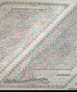
Sold2022Mitchell's Map of the states of Louisiana, Mississippi, & Alabama 1834MITCHELL, Samuel Augustus (1790-1868). Map of the states of Louisiana, Mississippi, & Alabama. Engraved map with original hand color. Philadelphia: S. Augustus Mitchell, 1834. 17 1/2" x 12 1/2" sheet.See Sold Price
Sold2017Tennessee Alabama Mississippi Louisiana Arkansas, 1895Map: Tennessee, Alabama, Mississippi, Louisiana and Arkansas Barne's Complete Geography Date: 1895 Size: 12 x 9.5 inches Please note that this lot has a confidential reserve. When you leave a bid in aSee Sold Price
Sold20171860 MAP LOUISIANA, MISSISSIPPI, ARKANSASFramed hand colored 1860 map, 'Map of Louisiana, Mississippi and Arkansas" by Augustus Mitchell (American, 1790-1868), sight: 14"h, 11.25"w, overall: 21.5"h, 18.75"w, 4.25lbs Start Price: $100.00See Sold Price
Sold20201861 Arkansas, Louisiana & Mississippi. By Johnson.Title: 1861 Arkansas, Louisiana & Mississippi. By Johnson. Date/Period: 1861 Materials: Steel engraved. Size: 25 1/2 x 18” 1861. By A. J. Johnson & J. H Colton. From "Johnson's New Illustrated FamilSee Sold Price
Sold2018Colton: Antique Map of Mississippi, 1859Title/Content of Map: Mississippi by Colton Date Printed: 1859 Cartographer: H. J. Colton Material/Medium: Paper Size: 14" x 17" Provenance: New York Published in New York Please note that this lot haSee Sold Price
Sold2017Colton: Antique Map of Louisiana, 1859Title/Content of Map: Louisiana by Colton Date Printed: 1859 Cartographer: H. J. Colton Material/Medium: Paper Size: 17 1/2" x 15" Hand colored engraved. Published in New York in 'Colton's General AtlSee Sold Price
Sold2018Early 19th Century Map of LouisianaEarly 19th Century Map of Louisiana(Baltimore: F. Lucas, 1817), engraving with outline color, depicts adjacent areas in Mississippi, Alabama, Florida, Texas and Arkansas (being labeled "Missouri"). PrSee Sold Price
Sold20231859 Map of Alabama by ColtonTitle: 1859 Map of Alabama by Colton Date/Period: 1859 Materials: Steel engravedSize: 17 1/2 x 14 1/2” Alabama. From before the civil war. By J. H. Colton & G. W. Colton. From "General Atlas". PSee Sold Price
Sold2017J. H. Colton: Map of Mexico & Texas, 1854.Mexico (includes part of Texas). J. H. Colton, 1854. 12.75 x 16. From the 1856 second edition of Colton’s Atlas of the World. Nice color and good impression. Clean. Hint of edge toning at sides. TwoSee Sold Price
Sold2016Map of North America...David H. Vance, engraved by J.H. Young. Philadelphia: Anthony Finley, 1825. Engraved map in 5 parts with original hand color in outline. 25 7/8 x 20 1/2 inches sheet, 30 5/8 x 25 1/2 inches framed.See Sold Price
Sold2020Rare 1st ed/1st state NYC map by ColtonA rare and beautiful example of J. H. Colton map of New York City and vicinity, including Manhattan as well as parts of Brooklyn, Jersey City, Hoboken, and Queens. This is the first edition, first staSee Sold Price
Sold2017C.1721 MAP OF LOUISIANA AND MISSISSIPPI RIVERBy John Senex. Dimensions: (Frame) H 24" x W 27.5" (Sight) H 19.75" x W 23" Condition: Creases to paper from previous folds and discoloration and stains to the center of the paper. Wear to gilt frame.See Sold Price
Sold2023Map of Maryland, Virginia Texas +Map of South Carolina, Georgia, Florida, Alabama, Mississippi, Louisiana, Tennessee and Arkansas PLUS Maryland, Virginia, West Virginia & North Carolina [1 half sheet side] & Texas [1 half sheet side]See Sold Price
Sold2016Large 1862 US Civil War Wall MapColton's Map of the Southern States. Including Maryland, Delaware, Virginia, Kentucky, Tennessee, Missouri, North Carolina, South Carolina, Georgia, Alabama, Mississippi, Arkansas, Louisiana, Texas ..See Sold Price
Sold2022Johnson's Arkansas, Mississippi, and Louisiana Map by Johnson and Ward, presented in an ebonizedJohnson's Arkansas, Mississippi, and Louisiana Map by Johnson and Ward, presented in an ebonized frame, H.- 24 3/8 in., W.- 17 1/4 in., Framed H.- 33 3/4 in., W.- 23 3/4 in. Provenance: from the EstatSee Sold Price
Sold2019Three Maps by Samuel Augustus Mitchell (1790-1868), "Three Maps by Samuel Augustus Mitchell (1790-1868), " County Maps of Arkansas, Louisiana and Mississippi, Verso with Florida, and a Plan of New Orleans" 1882, hand colored, on two pages, H.-24 in., W.See Sold Price
Sold2022Louisiana & Alabama with Mississippi, 1864 scarce publication by SchonbergTitle: Louisiana & Alabama with Mississippi, 1864 scarce publication by Schonberg Date/Period: 1864 Materials: Hand colored steel plate engraved. Size: 14 x 12 inches 1864 uncommon civil war era map bSee Sold Price
May 11Crescent City Auction GalleryRhoda Brady Stokes (Louisiana/Mississippi, 1902-1988), "Dener Time," H.- 5 in., W.- 7 in., Framed-$325
May 11Crescent City Auction GalleryRhoda Brady Stokes (Louisiana/Mississippi, 1902-1988), "Cajun Country," 1979, H.- 8 in., W.- 10 in.,$325
May 11Crescent City Auction GalleryRhoda Brady Stokes (Louisiana/Mississippi, 1902-1988), "The Noon Hour," 1972, H.- 18 in., W.- 24$750
May 11Crescent City Auction GalleryRhoda Brady Stokes (Louisiana/Mississippi, 1902-1988), "Scrapping Cotton the Old Way," 1976, H.- 18$750
May 11Crescent City Auction GalleryRhoda Brady Stokes (Louisiana/Mississippi, 1902-1988), "Bayou Grosse Tete," 1973, H.- 16 in., W.- 20$650
May 11Crescent City Auction GalleryRhoda Brady Stokes (Louisiana/Mississippi, 1902-1988), "Walking to School," 1954, H.- 20 in., W.- 28$650
May 11Crescent City Auction GalleryRhoda Brady Stokes (Louisiana/Mississippi, 1902-1988), "Quilts Drying in the Henyard," 1976, H.- 5$325
May 11Crescent City Auction GalleryRhoda Brady Stokes (Louisiana/Mississippi, 1902-1988), "Cabin in the Woods," 1974, H.- 18 in., W.-$650
May 14Akiba Galleries(2 Pc) Allain Manesson Mallet Description De L'Univers 2 Vol. German Translation$200(1 bid)
May 11Crescent City Auction GalleryWilliam H. Williams (1817-1886), New Orleans "Map of the Sixth District and Carrollton," 1871, H.-$650
May 10Crescent City Auction GalleryThree Silver Gelatin Photographs of Southern Rural Scenes, 20th c., Men- H.- 4 1/2 in., W.- 6 3/4 in$325
6 days LeftHunt and Peck Estate Services, Inc.1779 J. Carver "Travels Through The Interior Parts of North-America"$50
May 10Rail & Road AuctionsEleven Army Corps of Engineers Port Series No. 1 Through No. 8 Books with Fold Out Maps$35(2 bids)


![[MAPS & ATLASES]. COLTON, J.H. (1800-1893). Colton's New Topographical Map of The States Of: [MAPS & ATLASES]. COLTON, J.H. (1800-1893). Colton's New Topographical Map of The States Of Virginia, Maryland and Delaware, Showing Also Eastern Tennessee & Parts Of Other Adjoining States. New York:](https://p1.liveauctioneers.com/197/265299/138516337_1_x.jpg?height=310&quality=70&version=1666051328)


![Map of Maryland, Virginia Texas +: Map of South Carolina, Georgia, Florida, Alabama, Mississippi, Louisiana, Tennessee and Arkansas PLUS Maryland, Virginia, West Virginia & North Carolina [1 half sheet side] & Texas [1 half sheet side]](https://p1.liveauctioneers.com/5614/289638/153375966_1_x.jpg?height=310&quality=70&version=1684353133)


