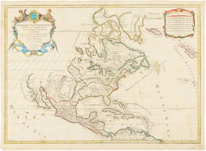
Sold2016Hubert Jaillot. Amerique Septentrionale diviséeHubert Jaillot. Amerique Septentrionale divisée en ses principales parties<See Sold Price
Sold2017Jaillot: Antique Map of North America, 1696Map: 1696 Jaillot Map of North America (California as an Island) -- Amerique Septentrionale Divisee en ses Principales Parties Date Printed: 1696 Amsterdam Cartographer: H. Jaillot Size: 19.3 x 23 in.See Sold Price
Sold2020A LOUIS XIV MAP, "L'Amerique Septentrionale," HUBERTA LOUIS XIV MAP, "L'Amerique Septentrionale," HUBERT JAILLOT, PARIS, 1696, hand colored engraving on paper, "Divisée en ses principals parties, ou sont distingués les uns des autres Les Estats suivaSee Sold Price
Sold2015Map of North America 1719Heading: (North America) Author: Sanson, Nicolas/ Hubert Jaillot Title: Amerique Septentrionale divisée en ses Principales Parties, ou sont distingués les uns des autres les Estats suivant quils appSee Sold Price
Sold20191792 Elwe Map of North America -- AmeriqueTitle/Content of Map: 1792 Elwe Map of North America -- Amerique Septentrionale Divisee en Ses Principales Parties Cartographer: J ElweDate: 1792, Amsterdam Size: 18.3 X 23.1 in. This is an outstandinSee Sold Price
Sold2023Jean Janvier - 18th Century Map of the AmericasJean Janvier (fl. 1746-1776), L'Amerique Septentrionale divisee en ses principaux Etats…, Paris, 1762, engraving on laid paper with hand colored highlights, sight 14-1/8 x 19-3/4 in.; wood framSee Sold Price
Sold2023JEAN DENIS JANVIER (FRENCH, FL, 1746-1779) MAP OF NORTH AMERICAJEAN DENIS JANVIER (FRENCH, FL, 1746-1779) MAP OF NORTH AMERICA, hand-colored copper-plate engraving, titled L'Amerique Septentrionale divisee en ses principaux Etats, Paris, 1See Sold Price
Sold20241782 Janvier/Lattre French Map of North America1782 Janvier/Lattre, L'Amerique Septentrionale Divisee en ses Principaux map of North America including the present day United States, Canada, Mexico, Central America, the Caribbean, Cuba, Florida, thSee Sold Price
Sold2022South America.- Jaillot (Alexis-Hubert) Amerique Meridionale Divisee en ses Principales Parties ouSouth America.- Jaillot (Alexis-Hubert) Amerique Meridionale Divisee en ses Principales Parties ou sont Distingues les uns des Autres les Estats Suivant Quils Appartiennent Presentement aux Francois,See Sold Price
Sold2016Hand Colored Engraved Map,Hubert JaillotAfter Hubert Jaillot (1632-1712) "Amerique Septentrionale divisee on ses principales parties". Hand colored engraved map of North American under the French power of Louis XIV. [Sight: 22 1/2" H x 35"See Sold Price
Sold2020Hubert Jaillot Map South America 1719Hubert Jaillot (1632-1712), "Amerique Meridionale divisee en ses pricipales Parties ou sont distingues les uns des autres les Estats suivant qu'ils appartiennent presentement aux Francois, Castillans,See Sold Price
Sold2017Jaillot Map of South America, 1690Title: 1690 Jaillot Map of South America Cartographer: AH Jaillot Published: 1690 c. Paris Measurements: 22 x 35 in. Amerique Meridionale divisee en ses Principales Parties ou sont distingues les unsSee Sold Price
Sold2018Nolin: Map of the Americas with New Discoveries InsetTitle/Content of Map: Carte d'Amerique divisee en ses principaux etats. Cartographer: J. B. Nolin Place & Date: Paris / 1818 Size: 28 1/2" x 20 1/4" Condition: Wash color; overall age toning; some papSee Sold Price
Sold2017Janvier Map L'AmeriqueL'Amerique divisée en ses principaux Etats...Janvier Sr. (18th. century). Engraved map with original hand color in full. Paris, 1760. 22 x 28 1/2 inches sheet.See Sold Price
Sold2022A large hand colored map of the Western hemisphere by Jean-Baptiste Louis ClouetA large hand colored map of the Western hemisphere by Jean-Baptiste Louis Clouet, printed on heavy laid paper and titled Carte D'Amerique divisee en ses principaux Pays, Dressee sur les Memoires les pSee Sold Price
Sold2018Delamarche: Antique Map of the Americas, 1818Title/Content of Map: Carte Generale De L'amerique Divisee En Ses Principaux Etats Date Printed: 1818 Cartographer: DELAMARCHE, FELIX apres Robert de Vaugondy Size: 21X23.3 Period map with areas of noSee Sold Price
Sold20191792 Elwe Map of South America -- L'AmeriqueTitle/Content of Map: 1792 Elwe Map of South America -- L'Amerique Meridionale Divisee en ses Principales Parties Date: 1792, AmsterdamCartographer: J Elwe Size: 18.2 X 23.7 in. This is an outstandingSee Sold Price
Sold2024Janvier map of North AmericaHeading: (North America) Author: Janvier, Jean Title: L'Amerique septentrionale divisée en ses principaux etats Place Published: Paris Publisher:Chez Lattré Date Published: 1762 DescrSee Sold Price
Sold20171685 map of South America: L'Amerique Meridionale.[Sanson/South America] L’AMERIQUE MERIDIONALE DIVISEE EN SES PRINCIPALES PARTIES SCAVOIR LA TERRE FERME, LE PEROU, LE CHILI, LE BRESIL, LE PARAGUAY… 1685. (Title from upper margin.) South AmericaSee Sold Price
Sold2015North America with infant United States 1783Heading: Author: Delamarche, Charles François Title: Amérique Septentrionale divesée en ses principaux Etats Place Published: Paris Publisher: Date Published: 1783 Description:See Sold Price
Sold2018(2pc) ANTIQUE MAPS OF SOUTH AMERICAincluding Amerique Meridionale Divisee en ses Grandes Regions et Possessions... by Jean-Baptiste Nolin (1657?-1708), to serve the Introduction of l'Histoire Universelle du Baron de Puffendorf, coloredSee Sold Price
Sold2019Nicolas Sanson (1600-1667), "Amerique MeridionaleNicolas Sanson (1600-1667), "Amerique Meridionale divisee en ses Principales Parties au sont, Les Estats, Francois Castillans Portugais, Hollandois," 1691, hand colored, H.- 25 in., W.- 37 in.See Sold Price
Sold2020Grp: 5 Maps of Sicily Italy 18th/19th c. JaillotGroup of five 18th and 19th century maps of Sicily. Includes Hubert Jaillot , "La Sicile divisee en ses trois Provinces ou Valees, scavoir Valle Demona, Valle Di Noto, et Valle Di Mazara;" and GuillauSee Sold Price
Sold2022A.H. Jaillot - Monumental Map of AfricaAfrique Divisee en ses Principales Parties et ses Isles 49"x51" Paris, 1782, Framed 58x55x3.5See Sold Price
10 hrs LeftJasper52Carte L’Asie. Asia. Mughal Empire. Oirat Kingdom. Tartary. VAUGONDY 1750 map$300
23 hrs LeftLeland LittleRobert de Vaugondy's 18th-Century French Map of North America's Eastern Seaboard$50
10 hrs LeftJasper52Empire du Japon divisée en sept principales parties. Japan. DE VAUGONDY 1750 map$260
23 hrs LeftBADO e MART AUCTIONSUnited States. DE TOCQUEVILLE. De la Démocratie en Amérique.€2,000
23 hrs LeftBADO e MART AUCTIONSOptics. CHÉRUBIN d’ORLÉANS. La Dioptrique oculaire.€3,000
7 days LeftPiasaJames Pradier (1790-1852) Le Duc d'Orléans en uniforme de général de division,€300
2 hrs LeftPiguet Hôtel des VentesEnki Bilal (1951), Bateau , 13.12.1991, technique mixte sur papier, signée, dédicacée et datée,CHF 15,000
3 days LeftLouiza Auktion & AssociatesJulian SCHNABEL (Né en 1951) The Fall Of Tyll" , 2020€2,000
1 day LeftFreeman's | HindmanJoan Miró (Spanish, 1893-1983) Defilé de Mannequins en Laponie, 1969$3,000(1 bid)
19 hrs LeftForum AuctionsNapoleon family copy.- Mémoires pour servir a l'Histoire de France en 1815, first edition, from the£650
2 hrs LeftLOS ANGELES ESTATE AUCTIONJohannes Hermanus Barend Koekkoek - Strandgezicht met ruiters en bomschuit Oil on Board$100


![1685 map of South America: L'Amerique Meridionale.: [Sanson/South America] L’AMERIQUE MERIDIONALE DIVISEE EN SES PRINCIPALES PARTIES SCAVOIR LA TERRE FERME, LE PEROU, LE CHILI, LE BRESIL, LE PARAGUAY… 1685. (Title from upper margin.) South America](https://p1.liveauctioneers.com/179/104231/53361924_1_x.jpg?height=310&quality=70&version=1495213319)


