Sold2017Kaart Van Het Onderkoningschap Van Peru 1765 MapKaart Van Het Onderkoningschap Van Peru 1765 Map. Title/content of Map: 'kaart Van Het Onderkoningschap Van Peru, Zig Uitstrekkende Over Chili, Paraguay, En Andere Spaansche Landen: Als Ook Van BrazilSee Sold Price
Sold2018Bachiene/Schalekamp: Cuba, 1785Reserve Reduced! Title of Map: Kaart van het Eiland Cuba. Cartographer: Bachiene / Schalekamp Place/Date: Amsterdam / 1785 Size: 12 1/4" x 8 1/2" Condition: Outline color; overall age toning; some staSee Sold Price
Sold2019Attributed to Isaak Tirion (1705-1765), "Kaart Van HetAttributed to Isaak Tirion (1705-1765), "Kaart Van Het Eiland Terre-Nueve, Van Nieuw Schotland/Kanada," c. 1740, engraving on laid paper, H. - 9 in., W. - 13.5 in.See Sold Price
Sold2017Tirion: Antique Map of the Western Hemisphere, 1754Map: Nieuwe Kaart van het Westelykste Deel der Wereeld Cartographer: Isaac Tirion Place & Date: Amsterdam / 1754 Size: 14 1/4" x 13 1/4" Condition: wash color; light overall age toning; backed to reinSee Sold Price
Sold2023Antique Map of The Holy Land, Dated 1792"Generaale Kaart Van Het Beloofde Land" colored map of The Holy Land, covering present-day Israel and Palestine, bordered by Egypt and Syria. Dated 1792, unframed. [22 x 26 inches]. Dry, losses, creasSee Sold Price
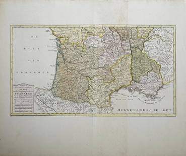
Sold2019Isaak Tirion (1705-1765, Amsterdam), "Nieuwe Kaart vanIsaak Tirion (1705-1765, Amsterdam), "Nieuwe Kaart van het Zuidelykste Gedeltevan Frankryk," 1757, hand colored, H. - 16 7/8 in., W. - 20 7/8 in.See Sold Price
Sold20191766 Beautiful Handcolored Map Cayenne1766 hand colored engraved map and plan “Land-Kaart van het Eiland en de Volkplanting van Cayenne aus de Kust van Zuid-Amerika”, by Isaak Tirion,. Fine, close right margin. Measures 18 x 16”, foSee Sold Price
Sold2017Bellin: Antique Map of The Mexican Heartland, 1754Map: Carte du Mexique/Kaart van het Mexico Cartographer: Bellin / van der Schley Place & Date: Amsterdam / 1754/1771 Size: 12" x 8 1/2" Condition: wash color; a beautifully colored and preserved exempSee Sold Price
Sold2017An antique map of Poland by Izaak Tirion, circa 1740An antique map of Poland by Izaak Tirion, circa 1740 Title: [Old Antique map of Poland / Lithuania] Nieuwe Kaart van het Koninkryk Poolen. Author: Tirion, Izaak , Amsterdam, c. 1740. DescriSee Sold Price
Sold2016Map, Isaak Tirion, Nieuwe Kaart Van EuropaIsaak Tirion (Dutch, 1705-1765), "Nieuwe Kaart Van Europa," hand-colored copper engraving, overall (with frame): 19"h x 21"wSee Sold Price
Sold2019Map of England & Wales 1760Heading: (Maps) Author: Tirion, Isaac Title: Nieuwe Kaart van 't Zuider Gedeelte van Groot Britannie behelzende Het Koningryk Engeland… Place Published: Amsterdam Publisher: Date Published: 1See Sold Price
Sold2017MAP, C. 1750, INDIA & SOUTHEAST ASIA, ISAAK TIRIONFramed map of India an nearby countries, "Nieuwe Kaart van India over de Ganges of van Malakka, Siam, Cambodia, Chiampa, Kochinchina, Laos, Pegu, Ava" c. 1750 by Issak Tirion (Dutch, 1705-1765), handSee Sold Price
Sold2024James Cook - Antique map Australia titled 'Gezigt van het Eil. Suffren'. Antique map of SuffrenAntique map Australia titled 'Gezigt van het Eil. Suffren'. Antique map of Suffren Island. Originates from 'Reizen Rondom de Waereld door James Cook (..)'. Artists and Engravers: Translated by J.D. PaSee Sold Price
Sold2023Van Keulen map of the Chesapeake Bay AreaVAN KEULEN, Johannes (1654-1715). Pas Kaart van de Zee Kuysten van Virginia. Engraved map with original hand color in part. Amsterdam, circa 1695. 20 3/4” x 24” sheet, 25” x 28 1/2&rSee Sold Price
Sold20241780 Gravitus Map of North America -- Kaartje van het Noorder-Deel van AmericaTitle: 1780 Gravitus Map of North America -- Kaartje van het Noorder-Deel van America Cartographer: N Gravitus Year / Place: 1780, Amstre Map Dimension (in.): 6.8 X 9.1 in. This is an unusual and rareSee Sold Price
Sold2018Early Map HET BELEG VAN HAARLEMEarly Map HET BELEG VAN HAARLEM; Size: image 11 in. x 13.5 in. ; full sheet 15.5 in. x 16.5 in.See Sold Price
Sold2019India.- Tirion (Isaac) Nieuwe Kaart van t Keyzer RykIndia.- Tirion (Isaac) Nieuwe Kaart van t Keyzer Ryk van den Grooten Mogol, map of The Mughal Empire, which included India, Sri Lanka, Pakistan and Bangladesh, engraved map with hand-colouring on laidSee Sold Price
Sold2017Kitchin: Antique Map Gulf of Mexico / West Indies, 1778Map: Kaart van de Golf van Mexico, de Eilanden en de Aangrenzende Landschappen Cartographer: Thomas Kitchin Place & Date: Amsterdam / 1778 Size: 19 1/8" x 12 1/4" Condition: b&w; a beautifully preservSee Sold Price
Sold2017Tirion: Antique Map of Isthmus of Panama, 1750Map: Kaart van de Landengte van Panama (Isthmus of Panama) Cartographer: Tirion Place & Date: Amsterdam / 1750 Size: 11 7/8" x 10 5/8" Condition: wash color; light overall age toning A beautifully desSee Sold Price
Sold2017Tirion: Antique Map of Panama, 1750Map: Kaart van de Landengte van Panama Cartographer: Tirion Place & Date: Amsterdam / 1750 Size: 11 7/8" x 10 5/8" Condition: b&w; overall age toning and minor spotting A beautifully designed and highSee Sold Price
Sold2023AFTER NICOLAS SANSON (FRENCH, 1600-1667) MAP OF FLORIDAAFTER NICOLAS SANSON (FRENCH, 1600-1667) MAP OF FLORIDA, hand-colored engraving on laid paper, titled "FLORIDA / zoo als het van de / SPAANSCHEN en FRANSCHEN / wordt bezeten. / door N. Sanson. /See Sold Price
Sold2019Isaak Tirion (1705-1765), "Kaart van hel WestelykIsaak Tirion (1705-1765), "Kaart van hel Westelyk Gedeelte van Nieuw Mexico en van California," 1765, hand colored, H.- 15 in., W.- 19 in.See Sold Price
Sold20201684 Pas kaart Van de Caribes Tusschen I. Barbados en IThis is an authentic antique map of the Lesser Antilles by Johannes Van Keulen. The map was published in Amsterdam in the year 1684. This is an impressive hand colored example of Van Keulen’s nSee Sold Price
Sold2022KEULEN, JOHANNES VAN Pas kaart Van de Boght van Florida Met de Canaal Tusschen Florida en Cuba Door.KEULEN, JOHANNES VAN Pas kaart Van de Boght van Florida Met de Canaal Tusschen Florida en Cuba Door. Amsterdam: Gerard Van Keulen, [1734]. Fifth state. Engraved map, hand colored, framed; sheet measurSee Sold Price
2 days LeftBucklinCoppens,Martien; Monsters van de Peel [RARE 1958 1ST EDITION -- NEAR FINE COPY]$100
2 days LeftTrillium Antique Prints & Rare BooksDe Jode, Rare, pub. 1593 - Map of Part of Germany (Sveviae Utriusq cum Germicae tum Rheticae$100


![Antique Map of The Holy Land, Dated 1792: "Generaale Kaart Van Het Beloofde Land" colored map of The Holy Land, covering present-day Israel and Palestine, bordered by Egypt and Syria. Dated 1792, unframed. [22 x 26 inches]. Dry, losses, creas](https://p1.liveauctioneers.com/1221/303742/163342134_1_x.jpg?height=310&quality=70&version=1697564518)


![An antique map of Poland by Izaak Tirion, circa 1740: An antique map of Poland by Izaak Tirion, circa 1740 Title: [Old Antique map of Poland / Lithuania] Nieuwe Kaart van het Koninkryk Poolen. Author: Tirion, Izaak , Amsterdam, c. 1740. Descri](https://p1.liveauctioneers.com/6018/113868/58519818_1_x.jpg?height=310&quality=70&version=1513369839)


![KEULEN, JOHANNES VAN Pas kaart Van de Boght van Florida Met de Canaal Tusschen Florida en Cuba Door.: KEULEN, JOHANNES VAN Pas kaart Van de Boght van Florida Met de Canaal Tusschen Florida en Cuba Door. Amsterdam: Gerard Van Keulen, [1734]. Fifth state. Engraved map, hand colored, framed; sheet measur](https://p1.liveauctioneers.com/292/250642/130213613_1_x.jpg?height=310&quality=70&version=1654271664)


![Coppens,Martien; Monsters van de Peel [RARE 1958 1ST EDITION -- NEAR FINE COPY] (1 of 4)](https://p1.liveauctioneers.com/8658/325945/175541633_1_x.jpg?height=282&quality=70&version=1712964944)


