Sold2016[Manuscript map] PLAN OF BRADFORD. 1844.[New Hampshire/Manuscript Map] PLAN OF BRADFORD. Manuscript plat map showing the various plots of land in Bradford, a post-township in Hillsborough Co., New Hampshire. Each plot is labeled with the naSee Sold Price
Sold20181844 Plans/Maps of the Ohio River at Louisville --Reserve Reduced! Title/Content of Map: 1844 Plans/Maps of the Ohio River at Louisville -- Report of the Secretary of War… A copy of the report of Captain T. J. Cram, on the best mode of improving thSee Sold Price
Sold2022[MANUSCRIPT MAP-MAINE] CHADWICK, JOSEPH. Plan of part of the lands belonging to the Heirs of Brigd.r[MANUSCRIPT MAP-MAINE] CHADWICK, JOSEPH. Plan of part of the lands belonging to the Heirs of Brigd.r Waldo ... measured by Joseph Chadwick Nov.r 1765. [New England]: November, 1765. Manuscript surveySee Sold Price
Sold2022KENT – LYDD – MANUSCRIPT ESTATE MAP 'A Map of a Farm lying in the Parish of Lydd in ...KENT – MANUSCRIPT ESTATE PLAN 'A Map of a Farm lying in the Parish of Lydd in the County of Kent Belonging to the Reverd. Mr Richard Monins 1774.', manuscript map by Henry Maxted & Isaac Terry,See Sold Price
Sold2022FOUR REFERENCE BOOKS ON MAPS, CHINA AND TAIWAN. Comprising The Authentic Story of Taiwan, AnFOUR REFERENCE BOOKS ON MAPS, CHINA AND TAIWAN. Comprising The Authentic Story of Taiwan, An Illustrated Hardback of History, based on Ancient Maps, Manuscripts and Plans; China in European Maps by HoSee Sold Price
Sold2020Bradford Map of New York City 1/170Heading: (New York) Author: Andrews, William Loring Title: James Lyne's Survey Or, as It is More Commonly Known the Bradford Map: a Plan of the City of New York at the Time of the Granting of the MontSee Sold Price
Sold2023Manuscript Map of Givet, France on the Belgian Border[Givet, France]. "Charlemont les deux Givets et la Couronne d'Haurs Pour servir au Projet de mil Sept cent trente sept" Fine manuscript plan in ink and colours on paper (no visible watermark), scale aSee Sold Price
Sold2022(MANUSCRIPT MAP -- SICILY.) Carta Topografica della Citta d'Agosta Co'suoi Contorni.(MANUSCRIPT MAP -- SICILY.) Carta Topografica della Citta d'Agosta Co'suoi Contorni. Pen, ink, and wash-colored plan of the ports and town of ancient Augusta on the Ionian coast of Sicily. Heavy laidSee Sold Price
Sold2020India.- Royal Bengal Engineers.- Sketch Plan of theIndia.- Royal Bengal Engineers.- Sketch Plan of the City of Lucknow, large manuscript map of the capital of the state of Uttar Pradesh, pen and inks, watercolour wash, traces of pencil, on wove paper,See Sold Price
Sold20201844 Boynton Map of Boston -- Plan of the City ofTitle/Content of Map: 1844 Boynton Map of Boston -- Plan of the City of Boston… Cartographer: G Boynton Year/Place: 1844, Boston Size: 9.6 X 11.2 in. This is an impressive striking plan of Boston feSee Sold Price
Sold202418th c. Siege Map/PlanAn attractive hand-colored manuscript plan of siege by the King of Sardinia. Ca. 18th century. On laid sheet with watermark, 14.75" x 10.5".See Sold Price
Sold2022[MANUSCRIPT MAP-FLORIDA & MISSISSIPPI RIVER] Map Showing Raiford's Proposed Artificial River and[MANUSCRIPT MAP-FLORIDA & MISSISSIPPI RIVER] Map Showing Raiford's Proposed Artificial River and Plan to Continue the Western and Southern Inland System of Navigation to Harbors in the Atlantic. [FernSee Sold Price
Sold2022Plan of St. Andrews Links Booklet with MapEarly booklet with folding map Plan of Golf Courses, showing Old, New and Jubilee Courses. Robert Forgan & Son, Scotland ad inside front cover. Early manuscript note verso. Rare book pocket map cartogSee Sold Price
Sold202019th C. Plan of the city of New York from an actual19th C. - A plan of the city of New York from an actual survey Known as the Bradford Plan. By James Lyne and Publisher:New-York : Pubed. by G. Hayward. Notes: Facsimile of an original map [New York :See Sold Price
Sold2021Scarce 1850 reissue of 1729 Jas. Lyne mapTitle: Scarce 1850 reissue of 1729 Jas. Lyne map Description: “Plan of New York in 1729 surveyed by James Lyne,” reissued for Valentine’s Manual of 1850. Most likely a copy of “The Bradford MaSee Sold Price
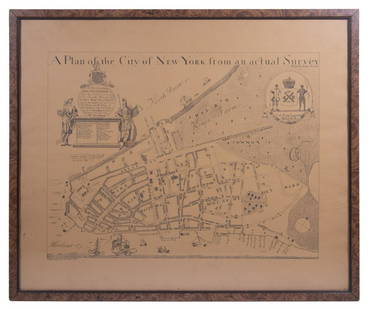
Sold2023REPLICA OF LAING'S MAP OF MANHATTAN"A Plan of the City of New York from an actual Survey" for His Excellency John Montgomerie, by William Bradford, printed on tan paper, in a faux tortoiseshell frame, under glass, 23" x 26", good condiSee Sold Price
Sold2021Manuscript Map of the Holy Land, early 18th Century[Manuscript map of the Holy Land] Pencil, ink, and watercolor on faux vellum with horizontal and vertical folding creases (8 segments) and no mounting guard; pencil grid visible in upper left and righSee Sold Price
Sold2022(MANUSCRIPT MAP -- CAPE TOWN.) Vue de Cap de Bonne Esperence.(MANUSCRIPT MAP -- CAPE TOWN.) Vue de Cap de Bonne Esperence. Pen and ink and watercolor wash on laid paper. 12¾x22¾ inches sheet size, ample margins; stain at right edge, backed with thin tSee Sold Price
Sold2022(KOREA.) Large manuscript map of the Kingdom of Joseon.(KOREA.) Large manuscript map of the Kingdom of Joseon. Ink and watercolor on thin paper. 24x26¼ inches overall; archivally lined on verso. Np, early 19th centurySee Sold Price
Sold2022(MANUSCRIPT MAP.) A. Rogers. A Chart of the World According to Mercator's Projections.(MANUSCRIPT MAP.) A. Rogers. A Chart of the World According to Mercator's Projections. Ink and watercolor on four joined sheets of "Potts & Reynolds" watermarked laid paper. 25x31½ inches overallSee Sold Price
Sold2024China.- Chinese School (19th century) Manuscript plan view of a section of the Great Wall andChina.- Chinese School (19th century) Manuscript plan view of a section of the Great Wall and surrounding hill-top fortifications, the text appraently includes a reference to the year 1479, within theSee Sold Price
Sold2017Harrison: Antique Map Plan of London, 1776Title/Content of Map: 'A new and complete plan of London, Westminster and Southwark, with the additional buildings to the year 1777' Date Printed: 1776 Image Size: Approx 29.5 x 51.0cm, 11.5 x 20 inchSee Sold Price
Sold2020[AUSTRIA]. Manuscript Map. 18th Century[Unknown Artist] "Geographischemappa des untern Kreis in Hertzzogthum Carnthen". Manuscript. Ink and watercolour on paper, dissected and mounted to cloth. Mid 18th century. 100cm x 67cm.See Sold Price
Sold2017Munster: Antique Map Plan of Cusco, 1550Map: Die Statt Cusco Cartographer: Sebastian Munster Place & Date: Basle / 1550 Size: 14 3/4" x 10 5/8" Condition: B&W; overall age toning; some browning along centerfold and outer edges of margins; aSee Sold Price
21 hrs LeftDoyle New YorkThe top sheet of the famous Ratzer Map - with additions relating to an 1810 real estate dispute$7,500
21 hrs LeftDoyle New YorkGoerck's 1785 working survey of the Common Lands that became Fifth Avenue$1,000
May 16Zikorn Arts & History ObjectsWest Indies Pt. Manzanilla to San Juan 1844 British Admiralty Map$100


![[Manuscript map] PLAN OF BRADFORD. 1844.: [New Hampshire/Manuscript Map] PLAN OF BRADFORD. Manuscript plat map showing the various plots of land in Bradford, a post-township in Hillsborough Co., New Hampshire. Each plot is labeled with the na](https://p1.liveauctioneers.com/179/93063/47518624_1_x.jpg?height=310&quality=70&version=1472482862)
![[Manuscript map] PLAN OF BRADFORD. 1844. First Image](https://p1.liveauctioneers.com/179/93063/47518624_1_x.jpg?height=300&quality=1&version=1472482862&width=300)
![[Manuscript map] PLAN OF BRADFORD. 1844. First Image](https://p1.liveauctioneers.com/179/93063/47518624_1_x.jpg?height=300&quality=95&version=1472482862&width=300)

![[MANUSCRIPT MAP-MAINE] CHADWICK, JOSEPH. Plan of part of the lands belonging to the Heirs of Brigd.r: [MANUSCRIPT MAP-MAINE] CHADWICK, JOSEPH. Plan of part of the lands belonging to the Heirs of Brigd.r Waldo ... measured by Joseph Chadwick Nov.r 1765. [New England]: November, 1765. Manuscript survey](https://p1.liveauctioneers.com/292/250642/130213647_1_x.jpg?height=310&quality=70&version=1654271664)


![Manuscript Map of Givet, France on the Belgian Border: [Givet, France]. "Charlemont les deux Givets et la Couronne d'Haurs Pour servir au Projet de mil Sept cent trente sept" Fine manuscript plan in ink and colours on paper (no visible watermark), scale a](https://p1.liveauctioneers.com/1968/273926/143704769_1_x.jpg?height=310&quality=70&version=1672435208)


![[MANUSCRIPT MAP-FLORIDA & MISSISSIPPI RIVER] Map Showing Raiford's Proposed Artificial River and: [MANUSCRIPT MAP-FLORIDA & MISSISSIPPI RIVER] Map Showing Raiford's Proposed Artificial River and Plan to Continue the Western and Southern Inland System of Navigation to Harbors in the Atlantic. [Fern](https://p1.liveauctioneers.com/292/250642/130213644_1_x.jpg?height=310&quality=70&version=1654271664)


![Manuscript Map of the Holy Land, early 18th Century: [Manuscript map of the Holy Land] Pencil, ink, and watercolor on faux vellum with horizontal and vertical folding creases (8 segments) and no mounting guard; pencil grid visible in upper left and righ](https://p1.liveauctioneers.com/1968/225974/116712048_1_x.jpg?height=310&quality=70&version=1636655147)


![[AUSTRIA]. Manuscript Map. 18th Century: [Unknown Artist] "Geographischemappa des untern Kreis in Hertzzogthum Carnthen". Manuscript. Ink and watercolour on paper, dissected and mounted to cloth. Mid 18th century. 100cm x 67cm.](https://p1.liveauctioneers.com/1124/187577/94368842_1_x.jpg?height=310&quality=70&version=1607095126)


