Sold2017Bradford: Map of Turkey, 18351835 Bradford map of Turkey. 7.75 x 10. This unusual map by Thomas Gamaliel Bradford depicts the Asian portions of Turkey, the Black Sea, the Caucuses (Georgia, Azerbaijan, and Armenia), and what is tSee Sold Price
Sold2017Bradford: Antique Map of Massachusetts, 18351835 Bradford map of Massachusetts. Nice early map of the state of Massachusetts by Thomas Gamaliel Bradford. Original hand coloring. Clean with good margins. 7.5 x 10 inches. Thomas G. Bradford was tSee Sold Price
Sold2017Bradford: Jerusalem, Athens, Rome & Mount Sinai, 1835Map Title: Jerusalem, Athens, Rome & Mount Sinai Original engraving from Atlas Illustrations by Bradford Published in Boston Publishing Date: 1835 Dimensions: 15 1/2 x 13 1/4 inches Thomas Gamaliel BrSee Sold Price
2021Bradford's Map of Texas 1835/36"Bradford's Map of Texas, 1st Separate Map of Texas to Appear in an Atlas" by Thomas G. Bradford, copper engraving with hand-colored outlines, published Boston, 1835/1836, together with accompanying aSee Sold Price
Sold2017Bradford: Antique Map of Texas, 1841Item: Map of Texas Maker: Thomas J. Bradford Date: 1841 Matted Size: With matte measures 18 1/2" x 15 3/4" Please note that this lot has a confidential reserve. When you leave a bid in advance of theSee Sold Price
Sold2016American Atlas TG Bradford 1842Heading: Author: Bradford, Thomas Gamaliel and Samuel Griswold Goodrich Title: A Universal, Illustrated Atlas, exhibiting a Geographical, Statistical and Historical View of the World Place Published:See Sold Price
Sold2019Persia, Arabia, Tartary, AfghanistanTitle: Persia, Arabia, Tartary, Afghanistan Date: 1835 Cartographer: BRADFORD, THOMAS GAMALIEL Size: 10Height - 7.75Width Provenance: Margin waterstains Reserve: $40.00 Shipping: Domestic: Flat-ratSee Sold Price
Sold2020Indiana & OhioTitle/Content of Map: Indiana & Ohio Cartographer: Bradford, Thomas Gamaliel Date: 1835 Publisher: William D. Ticknor / Wiley & Long Size: 17.8Height - 10.1Width Regional map from T.G. Bradford's "A CSee Sold Price
Sold20211838 Thomas Bradford Atlas Map of MichiganAtlas map of Michigan showing then current counties, towns, etc. Hand colored borders. Along the bottom margin: “Entered according to Act of Congress in the year 1838 by T.G. Bradford in the ClerksSee Sold Price
Sold2018Pacific OceanReserve Reduced! Title/Content of Map: Pacific OceanDate: 1835 Cartographer: BRADFORD, THOMAS GAMALIEL Material/Medium: AMERICAN STATIONERS COMPANY Size: 7.75 x 10 inches Australia called New Holland.See Sold Price
Sold2022TRANSACTIONS OF AMERICAN PHILOSOPHICAL SOCIETY1771 PRINTED BY WILLIAM AND THOMAS BRADFORD W/ MAPS & PULLOUTSSee Sold Price
Sold20174 TN Maps, Bradford, 1835, 1838, & 18411st item: "Tennessee" Map, by Thomas G. Bradford, engraved by George W. Boynton, published by William D. Ticknor, Boston, 1835. From "A Comprehensive Atlas, Geographical, Historical & Commercial" by TSee Sold Price
Sold2017Bradford: Antique Map of the West Indies, 1838Title/Content of Map: Bradford's West Indes Date Printed: 1838/1841 Cartographer: Thomas G. Bradford Material/Medium: Paper Size: 16 3/4" x 13 1/4" Hand colored. A General Atlas of the World with a SeSee Sold Price
Sold20163 19th cent. Maps, 1 of TN and KY, 2 of TN1st item: "Tennessee & Kentucky" Map, drawn by Thomas G. Bradford, engraved by George W. Boynton, published by William D. Ticknor, Boston, 1835. From "A Comprehensive Atlas. Geographical, Historical,See Sold Price
Sold2017Bradford: Antique Map of Louisiana, 1838Title/Content of Map: Louisiana by Bradford Date Printed: 1838/1841 Cartographer: Thomas G. Bradford Material/Medium: Paper Size: 16 1/2" x 13" Hand colored. A General Atlas of the World with a SeparaSee Sold Price
Sold2020World, As Known to The Ancients.Title/Content of Map: World, As Known to The Ancients. Publication Date: 1835 Cartographer: BRADFORD, THOMAS GAMALIEL Publisher: T.G. BRADFORD Description: "This map contains all the parts of which itSee Sold Price
Sold2017Bradford: Antique Map of Kentucky, 1838Title/Content of Map: Kentucky by Bradford Date Printed: 1838/1841 Cartographer: Thomas G. Bradford Material/Medium: Paper Size: 16 1/2" x 13" Hand colored. A General Atlas of the World with a SeparatSee Sold Price
Sold2017Bradford: Antique Map of Pennsylvania, 1838Title/Content of Map: Pennsylvania by Bradford Date Printed: 1838/1841 Cartographer: Thomas G. Bradford Material/Medium: Paper Size: 16 1/2" x 13" Hand colored. A General Atlas of the World with a SepSee Sold Price
Sold2017Bradford: Antique Map of Massachusets, 1838Title/Content of Map: Massachusets by Bradford Date Printed: 1838/1841 Cartographer: Thomas G. Bradford Material/Medium: Paper Size: 13" x 16 1/2" Hand colored. A General Atlas of the World with a SepSee Sold Price
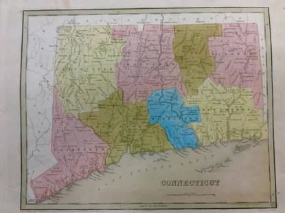
2017Bradford: Antique Map of Conneticut, 1838Title/Content of Map: Conneticut by Bradford Date Printed: 1838/1841 Cartographer: Thomas G. Bradford Material/Medium: Paper Size: 13" x 16 1/2" Hand colored. A General Atlas of the World with a SeparSee Sold Price
Sold2020Countries of The Ancient WorldTitle/Content of Map: Countries of The Ancient World Publication Date: 1835 Cartographer: BRADFORD, THOMAS GAMALIEL Publisher: T.G. BRADFORD Description: "exhibiting the probable settlement of the DesSee Sold Price
Sold2017Bradford: Antique Map of New Hampshire, 1838Title/Content of Map: New Hampshire by Bradford Date Printed: 1838/1841 Cartographer: Thomas G. Bradford Material/Medium: Paper Size: 13" x 16 1/2" Hand colored. A General Atlas of the World with a SeSee Sold Price
Sold2017Bradford: Map of Florida, 1835Map: Florida Cartographer: Thomas G. Bradford Illustrator: Thomas G. Bradford Edition: First Edition Publisher: Thomas G. Bradford Date: 1835 Size: 7.75 x 10.25 inches Beautiful, hand colored first edSee Sold Price
Sold2021Texas. A very important and rare first state firstTitle: Texas. A very important and rare first state first edition map. 1850 by Thomas. Date/Period: c1850 Size: 16 1/2 x 13 1/2 inches. Material: Hand colored steel engraved Description: A very importSee Sold Price
May 18Blackstone Valley Auctions & Estates LLCRevolutionary Era War Map of the Attack on Ft. Moultrie.$120(2 bids)
4 days LeftHunt and Peck Estate Services, Inc.1794 Laurie & Whittle after Thomas Jefferys Map Of The United States Of America$360(2 bids)
May 16Potter & Potter AuctionsSTORM, Mark. Official Texas Brags Map of North America. 194...$200(1 bid)
4 days LeftHunt and Peck Estate Services, Inc.1813 "A Concise History of the United States of America from the Discovery of America till 1813"$100(1 bid)
2 days LeftJasper521775-1780 Southwest (Arizona, New Mexico, Texas, with most of Mexico) by Bonne & Raynal$160(1 bid)
Jun 02Schilb Antiquarian Rare Books1871 Alfred the Great King of England MAP Battle of Ashdown Vikings Thom Hughes$1


![[Map]. Bradford, T[homas] G[amaliel]. Texas First Image](https://p1.liveauctioneers.com/514/11740/3078814_1_x.jpg?height=300&quality=1&version=1171465640&width=300)
![[Map]. Bradford, T[homas] G[amaliel]. Texas First Image](https://p1.liveauctioneers.com/514/11740/3078814_1_x.jpg?height=300&quality=95&version=1171465640&width=300)


![[SLAVERY] 1854 Texas Slave Hire Document (1 of 1)](https://p1.liveauctioneers.com/7226/322253/173251505_1_x.jpg?height=282&quality=70&version=1710004847)


