Sold2023Map of Coeur D'alene Indian Reservation - Idaho TerritoryPublication Date: 1888-02-06 Title: Map of Coeur D'alene Indian Reservation - Idaho Territory Cartographer: BRODIE, PAUL Publisher: HOUSE OF REPRESENTATIVES Height: 13.5 Width: 9.5 "copied in the OffiSee Sold Price
Sold2023Coeur D'alene Indian Reservation Area 598,499.85 Acres.Publication Date: 1887-10-20 Title: Coeur D'alene Indian Reservation Area 598,499.85 Acres. Cartographer: BAKER, DARIUS F./BRODIE, PAUL Publisher: HOUSE OF REPRESENTATIVES Height: 15.3 Width: 11.25 "cSee Sold Price
Sold2023Untitled. [Coeur D'alene Indian Reservation and Environs]Publication Date: 1888-02-07 Title: Untitled. [Coeur D'alene Indian Reservation and Environs] Cartographer: LAZELLE, HENRY MARTYN (1833-1917)/PAUL BRODIE Publisher: HOUSE OF REPRESENTATIVES Height: 12See Sold Price
Sold20221885 Map of US Indian Reservations"Map Showing the Location of the Indian Reservations within the limits of the United States and Territories". Published by United States Office of Indian Affairs, John D. C. Atkins, Commissioner of InSee Sold Price
Sold2021Coeur d'Alene Child & Dog & Chief PhotographsOffered in this lot are two vintage photograph portraits of Native American Indians from The Coeur d'Alene Idaho Tribe. The first is a hand colored photograph portrait of "An Indian Baby On The NortheSee Sold Price
Sold20191886 County & Township map of Arizona & N. Mexico byA fine example of William M. Bradley's 1886 map of Arizona and New Mexico. Shows just ten counties in Arizona Territory and thirteen in New Mexico Territory (plus Indian Reservation in upper left of sSee Sold Price
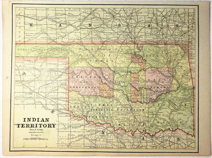
Sold2017Cram: Map of Indian Territory, 1889An original map published in 1889 depicting the Indian Reservations in what is now the state of Oklahoma. 9.5 x 12" Please note that this lot has a reserve. When you leave a bid in advance of the auctSee Sold Price
Sold2018Map: Territory of Arizona, 1899Territory of Arizona, 1899, Shows 9 Indian Reservations, Military, much more, good condition & contentSee Sold Price
Sold2018Handcolor map of Indian Territory - 1886Reserve Reduced! Finely engraved map that does not include the Public Lands of the panhandle. Filled with details of watershed, towns and villages, railroads, forts, military reservations, etc. DelineSee Sold Price
Sold2018Map of Railroad and County “Indian Territory"Map of Railroad and County “Indian Territory" 22" x 28" Map of Railroad and County “Indian Territory" (Rare!) shows Indian occupied Lands – Reservation in color, not dated but 1880’s likelySee Sold Price
Sold20167 folding maps: Indian Reservations (1892)-1920.[Native Americans/Indian Reservation Maps] 7 large folding maps showing locations of Indian reservations. ++ MAP SHOWING THE INDIAN RESERVATIONS WITHIN THE LIMITS OF THE UNITED STATES UNDER THE DIRECTSee Sold Price
Sold2024Civil War era map of N. America with unsettled state bordersOne of the key maps in the 1860s Johnson series of North America. In this map Idaho Territory encompasses what would eventually become Idaho, Montana and Wyoming. Dakota Territory has yet to split intSee Sold Price
Sold2022Civil War era map of N. America with unsettled state bordersOne of the key maps in the 1860s Johnson series of North America. In this map Idaho Territory encompasses what would eventually become Idaho, Montana and Wyoming. Dakota Territory has yet to split intSee Sold Price
Sold2020Indian Territory 1891Title/Content of Map: Indian Territory 1891 Date Printed: 1891 Material/Medium: Paper Size: approx 10.5x14.5 inches Additional Info: Cram's Atlas of the World. Geo. F. Cram, Chicago Reserve: $20.00 SSee Sold Price
Sold2020Indian Territory 1897Title/Content of Map: Indian Territory 1897 Date Printed: 1897 Material/Medium: paper Size: approx. 11x 13.5 inches Additional Info: Cram's Universal Atlas Reserve: $30.00 Shipping: Domestic: Flat-ratSee Sold Price
Sold2021Government map of Indian TerritoriesHeading: (Indian Territory) Author: Dinsmore, A. F., Lowe, R.P., Naylor, William, Cartographers Title: Indian Territory. Department of The Interior General Land Office. Hon. Thomas H. Carter, CommissiSee Sold Price
Sold20181890 Census Office Map of Indian Territory and OklahomaTitle/Content of Map: 1890 Census Office Map of Indian Territory and Oklahoma -- Map of Indian Territory and Oklahoma Date: 1890, Washington Cartographer: General Land Office / Census Office Size: 22.See Sold Price
Sold202119th C. Map of Indian Territory & 20th C. Kachina**Originally Listed At $300** Map: "Map of Indian Territory Drawn and Engraved on Copper Plate Expressly for Johnson's Cyclopedia" - Volume IV New York - A.J. Johnson Company, ca. 1880 to 1894. FigureSee Sold Price
Sold2021Scarce map of Indian Territory, 1886Most likely the final map of Indian Territory produced by the Colton firm. Map is colored by Indian Nations, and shows a massive Cheyennes and Arapahoes Nation at the top. Over two dozen Native AmericSee Sold Price
Sold2020Map of Indian TerritoryTitle/Content of Map: Map of Indian Territory Date: 1899 Cartographer: U.S. GEOLOGICAL SURVEY Publisher: U.S.G.S. Size: 32.5Height - 29.5Width showing distribution of woodland. Compiled under the direSee Sold Price
Sold2021Map of Indian Territory & KansasMap of Indian Territory Combined with Map of Kansas on Verso Color Map Dated: 19th century Dimensions: 10 x 6 1/2" Condition Report Good. TextSee Sold Price
Sold2016Map of Indian Territory and Oklahoma, J. Bein 1890Title: Map of Indian Territory and Oklahoma Subject: Oklahoma Maker: J. Bein Date: 1890, New York Size: 22.5 x 29.5 inches Map of the Indian Territory showing areas ceded to various tribes, each withSee Sold Price
Sold20181883 General Land Office Map of Indian TerritoryTitle/Content of Map: 1883 General Land Office Map of Indian Territory -- Indian Territory Date Printed: 1883, Washington Cartographer: General Land Office Size: 12 x 16 in. This is a highly detailedSee Sold Price
Sold2018Asher & Adams: Antique Map of Indian Territory, 1874Title/Content of Map: 1874 Asher & Adams Indian Territory Map -- Asher & Adams Indian Territory and Texas North West Portion Date Printed: 1874, New York Cartographer: Asher & Adams Size: 16.3 x 23.2See Sold Price
Jun 02Schilb Antiquarian Rare Books1886 INDIANS 1ed Sa-Go-Ye-Wat-Ha Red Jacket Seneca Revolutionary War Hubbard$1
3 days LeftJasper521764 Bowen Map of West India to Iran -- India As Described By All Authors Before The Fifth Century$80
May 12Schilb Antiquarian Rare Books1830 INDIANS 21st US Congress Acts LAW Sioux America Military Andrew Jackson$11(2 bids)


![Untitled. [Coeur D'alene Indian Reservation and Environs]: Publication Date: 1888-02-07 Title: Untitled. [Coeur D'alene Indian Reservation and Environs] Cartographer: LAZELLE, HENRY MARTYN (1833-1917)/PAUL BRODIE Publisher: HOUSE OF REPRESENTATIVES Height: 12](https://p1.liveauctioneers.com/5584/279712/147260338_1_x.jpg?height=310&quality=70&version=1677623547)


![7 folding maps: Indian Reservations (1892)-1920.: [Native Americans/Indian Reservation Maps] 7 large folding maps showing locations of Indian reservations. ++ MAP SHOWING THE INDIAN RESERVATIONS WITHIN THE LIMITS OF THE UNITED STATES UNDER THE DIRECT](https://p1.liveauctioneers.com/179/93063/47518619_1_x.jpg?height=310&quality=70&version=1472482862)


![(2) Comanche Portraits by Lenny & Sawyers [Cabinet Card] (1 of 2)](https://p1.liveauctioneers.com/7226/322253/173251539_1_x.jpg?height=282&quality=70&version=1710004847)


