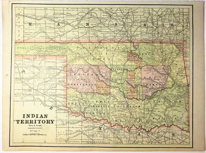
Sold2018Handcolor map of Indian Territory - 1886Reserve Reduced! Finely engraved map that does not include the Public Lands of the panhandle. Filled with details of watershed, towns and villages, railroads, forts, military reservations, etc. DelineSee Sold Price
Sold2021Scarce map of Indian Territory, 1886Most likely the final map of Indian Territory produced by the Colton firm. Map is colored by Indian Nations, and shows a massive Cheyennes and Arapahoes Nation at the top. Over two dozen Native AmericSee Sold Price
Sold20201886 Map of Oklahoma and the Indian TerritoryAuthor: Watson Title: 1886 Map of Oklahoma and the Indian Territory Medium: Ink on paper Dimensions: 14.5"X11" Map of Oklahoma and the Indian territory dated 1886. Part of Watson Universal Atlas publiSee Sold Price
Sold20191886 Cram Map of Texas [verso] Indian Territory [verso]Title/Content of Map: 1886 Cram Map of Texas [verso] Indian Territory [verso] Arkansas -- Texas [verso] Indian Ty. [verso] Arkansas Date: 1882, Chicago Cartographer: G CramSize: 12 X 17 in. This is aSee Sold Price
Sold20201886 Cram Map of Texas [verso] Indian Territory [verso]Title/Content of Map: 1886 Cram Map of Texas [verso] Indian Territory [verso] Arkansas -- Texas [verso] Indian Ty. [verso] Arkansas Cartographer: G Cram /People's Publishing Co. Year/Place: 1886, ChicSee Sold Price
Sold20201886 Cram Map of Texas [verso] Indian Territory [verso]Title/Content of Map: 1886 Cram Map of Texas [verso] Indian Territory [verso] Arkansas -- Texas [verso] Indian Ty. [verso] Arkansas Date: 1886, Chicago Cartographer: G Cram Size: 12 X 17 in. This is aSee Sold Price
Sold20221886 Cram Map of Texas [verso] Indian Territory [verso] Arkansas -- Texas [verso] Indian Ty. [verso]Title: 1886 Cram Map of Texas [verso] Indian Territory [verso] Arkansas -- Texas [verso] Indian Ty. [verso] Arkansas Cartographer: G Cram Year / Place: 1886, Chicago Map Dimension (in.): 11.8 X 17 in.See Sold Price
Sold20181886 Cram Map of Texas [verso] Indian Territory [and]Reserve Reduced! Title/Content of Map: 1886 Cram Map of Texas [verso] Indian Territory [and] Arkansas -- Texas [verso] Indian Ty. [and] Arkansas Date: 1886, Chicago Cartographer: G Cram Size: 11.8 x 1See Sold Price
Sold20191886 Cram Map of Texas [verso] Indian Territory [verso]Title/Content of Map: 1886 Cram Map of Texas [verso] Indian Territory [verso] Arkansas -- Texas [verso] Indian Ty. [verso] Arkansas Date: 1882, Chicago Cartographer: G Cram Size: 12 X 17 in. This is aSee Sold Price
Sold2018Cram: Antique Map of Texas, 1886Title/Content of Map: 1886 Cram Map of Texas / Arkansas and Indian Territory on Verso -- Texas; Arkansas; Indian Ty. Date Printed: 1886, Chicago Cartographer: G Cram Size: 11.8 x 17 in. Handsomely detSee Sold Price
Sold2020County Map of the State of Texas, 1886Excellent and detailed map of Texas colored by county and showing most of Indian Territory and New Mexico. In this map the Texas counties are still incomplete in the West. Features a large inset planSee Sold Price
Sold20191886 County & Township map of Arizona & N. Mexico byA fine example of William M. Bradley's 1886 map of Arizona and New Mexico. Shows just ten counties in Arizona Territory and thirteen in New Mexico Territory (plus Indian Reservation in upper left of sSee Sold Price
Sold2020Indian Territory 1891Title/Content of Map: Indian Territory 1891 Date Printed: 1891 Material/Medium: Paper Size: approx 10.5x14.5 inches Additional Info: Cram's Atlas of the World. Geo. F. Cram, Chicago Reserve: $20.00 SSee Sold Price
Sold2020Indian Territory 1897Title/Content of Map: Indian Territory 1897 Date Printed: 1897 Material/Medium: paper Size: approx. 11x 13.5 inches Additional Info: Cram's Universal Atlas Reserve: $30.00 Shipping: Domestic: Flat-ratSee Sold Price
Sold2021Government map of Indian TerritoriesHeading: (Indian Territory) Author: Dinsmore, A. F., Lowe, R.P., Naylor, William, Cartographers Title: Indian Territory. Department of The Interior General Land Office. Hon. Thomas H. Carter, CommissiSee Sold Price
Sold20181890 Census Office Map of Indian Territory and OklahomaTitle/Content of Map: 1890 Census Office Map of Indian Territory and Oklahoma -- Map of Indian Territory and Oklahoma Date: 1890, Washington Cartographer: General Land Office / Census Office Size: 22.See Sold Price
Sold202119th C. Map of Indian Territory & 20th C. Kachina**Originally Listed At $300** Map: "Map of Indian Territory Drawn and Engraved on Copper Plate Expressly for Johnson's Cyclopedia" - Volume IV New York - A.J. Johnson Company, ca. 1880 to 1894. FigureSee Sold Price
Sold2020Map of Indian TerritoryTitle/Content of Map: Map of Indian Territory Date: 1899 Cartographer: U.S. GEOLOGICAL SURVEY Publisher: U.S.G.S. Size: 32.5Height - 29.5Width showing distribution of woodland. Compiled under the direSee Sold Price
Sold2021Map of Indian Territory & KansasMap of Indian Territory Combined with Map of Kansas on Verso Color Map Dated: 19th century Dimensions: 10 x 6 1/2" Condition Report Good. TextSee Sold Price
Sold2016Map of Indian Territory and Oklahoma, J. Bein 1890Title: Map of Indian Territory and Oklahoma Subject: Oklahoma Maker: J. Bein Date: 1890, New York Size: 22.5 x 29.5 inches Map of the Indian Territory showing areas ceded to various tribes, each withSee Sold Price
Sold20181883 General Land Office Map of Indian TerritoryTitle/Content of Map: 1883 General Land Office Map of Indian Territory -- Indian Territory Date Printed: 1883, Washington Cartographer: General Land Office Size: 12 x 16 in. This is a highly detailedSee Sold Price
Sold2018Asher & Adams: Antique Map of Indian Territory, 1874Title/Content of Map: 1874 Asher & Adams Indian Territory Map -- Asher & Adams Indian Territory and Texas North West Portion Date Printed: 1874, New York Cartographer: Asher & Adams Size: 16.3 x 23.2See Sold Price
Sold2017Asher & Adams: Map of Indian Territory, 1874Map: Hand Colored Map of Indian Terratory Maker: Asher & Adams Date: 1874 Size: Approx. 16x22 inches First edition of this large format railroad map of IndianTerritory, from Asher & Adams' Atlas of thSee Sold Price
Jun 02Schilb Antiquarian Rare Books1886 INDIANS 1ed Sa-Go-Ye-Wat-Ha Red Jacket Seneca Revolutionary War Hubbard$1
5 days LeftJasper52COLONIAL CARIBBEAN. West Indies. Danish Virgin Islands.Telegraph cables 1886 map$40
5 days LeftJasper52Puerto Rico & Virgin Islands. Haiti, Hispaniola or St. Domingo. THOMSON 1817 map$130
4 days LeftJasper521764 Bowen Map of West India to Iran -- India As Described By All Authors Before The Fifth Century$80
5 days LeftJasper52Grand Bahama & Great Abaco Islands. Bahamas. ADMIRALTY sea chart 1886 (1968) map$140


![1886 Cram Map of Texas [verso] Indian Territory [verso]: Title/Content of Map: 1886 Cram Map of Texas [verso] Indian Territory [verso] Arkansas -- Texas [verso] Indian Ty. [verso] Arkansas Date: 1882, Chicago Cartographer: G CramSize: 12 X 17 in. This is a](https://p1.liveauctioneers.com/5584/137769/69881200_1_x.jpg?height=310&quality=70&version=1552435690)
![1886 Cram Map of Texas [verso] Indian Territory [verso]: Title/Content of Map: 1886 Cram Map of Texas [verso] Indian Territory [verso] Arkansas -- Texas [verso] Indian Ty. [verso] Arkansas Cartographer: G Cram /People's Publishing Co. Year/Place: 1886, Chic](https://p1.liveauctioneers.com/5584/175972/88577718_1_x.jpg?height=310&quality=70&version=1597183226)
![1886 Cram Map of Texas [verso] Indian Territory [verso]: Title/Content of Map: 1886 Cram Map of Texas [verso] Indian Territory [verso] Arkansas -- Texas [verso] Indian Ty. [verso] Arkansas Date: 1886, Chicago Cartographer: G Cram Size: 12 X 17 in. This is a](https://p1.liveauctioneers.com/5584/161241/81395745_1_x.jpg?height=310&quality=70&version=1581460166)
![1886 Cram Map of Texas [verso] Indian Territory [verso] Arkansas -- Texas [verso] Indian Ty. [verso]: Title: 1886 Cram Map of Texas [verso] Indian Territory [verso] Arkansas -- Texas [verso] Indian Ty. [verso] Arkansas Cartographer: G Cram Year / Place: 1886, Chicago Map Dimension (in.): 11.8 X 17 in.](https://p1.liveauctioneers.com/5584/270923/141842451_1_x.jpg?height=310&quality=70&version=1670433092)
![1886 Cram Map of Texas [verso] Indian Territory [and]: Reserve Reduced! Title/Content of Map: 1886 Cram Map of Texas [verso] Indian Territory [and] Arkansas -- Texas [verso] Indian Ty. [and] Arkansas Date: 1886, Chicago Cartographer: G Cram Size: 11.8 x 1](https://p1.liveauctioneers.com/5584/128997/65616692_1_x.jpg?height=310&quality=70&version=1539125359)
![1886 Cram Map of Texas [verso] Indian Territory [verso]: Title/Content of Map: 1886 Cram Map of Texas [verso] Indian Territory [verso] Arkansas -- Texas [verso] Indian Ty. [verso] Arkansas Date: 1882, Chicago Cartographer: G Cram Size: 12 X 17 in. This is a](https://p1.liveauctioneers.com/5584/144578/73088219_1_x.jpg?height=310&quality=70&version=1561513819)


![(2) Comanche Portraits by Lenny & Sawyers [Cabinet Card] (1 of 2)](https://p1.liveauctioneers.com/7226/322253/173251539_1_x.jpg?height=282&quality=70&version=1710004847)


