Sold2024Map of Dakota - Southern Portion.Publication Date: 1885 Title: Map of Dakota - Southern Portion. Cartographer: RAND, MCNALLY & CO. Publisher: H.H. HARDESTY & CO. Height: 13 Width: 19.3 Ornamental border. 194-195. From scarce HardestySee Sold Price
Sold2017Hardesty: Antique Map of Dakota-Southern Portion, 1883Title: Map of Dakota-Southern Portion by Hardesty Date: 1883 Medium: Wax Engraving Dimensions (in): 21 x 14.5 Condition: Excellent Condition No Reserve: This lot starts at $1 and has no reserve as a cSee Sold Price
Sold2023Chile, Argentina, Paraguay and Uruguay. South America. RAND MCNALLY 1906 mapTitle: Chile, Argentina, Paraguay and Uruguay. South America. RAND MCNALLY 1906 map Description: Argentine republic, Paraguay, Uruguay and chile, inside map southern portion of Chile and Argentine RepSee Sold Price
Sold20201792 Elwe Map of Southern Portion of Africa -- Carte deTitle/Content of Map: 1792 Elwe Map of Southern Portion of Africa -- Carte de l'Afrique Meridionale ou Pays entre la Ligne & le Cap de Bonne Esperance, et l'Isle de Madagascar Cartographer: J Elwe YeaSee Sold Price
Sold20191703 Delisle Map of Southern Portions of South AmericaTitle/Content of Map: 1703 Delisle Map of Southern Portions of South America -- Carte du Paraguay du Chili du Detroit de Magellan &c. Dressee sur les Descriptions des PP. Alfonse d'Ovalle, et NicolasSee Sold Price
Sold20211895 Rand McNally Map of New York City [verso] BrooklynTitle: 1895 Rand McNally Map of New York City [verso] Brooklyn -- Map of the Southern Portion of New York City [verso] Brooklyn Cartographer: Rand McNally Year / Place: 1895, Chicago Map Dimension (inSee Sold Price
Sold20181838 SDUK Map of Southern Ireland -- IrelandTitle/Content of Map: 1838 SDUK Map of Southern Ireland -- Ireland Date: 1838, London Cartographer: SDUK Size: 12.3 X 18.3 in. This map is the southern portion of Ireland, Dublin and south. This is aSee Sold Price
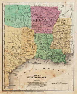
Sold20191872 Warner Beers Map Western Portion of SouthernReserve Reduced! Title/Content of Map: 1872 Warner Beers Map Western Portion of Southern States -- County Map of Tennessee, Kentucky, Alabama. Mississippi, Arkansas and Louisiana Date: 1872, Chicago CSee Sold Price
Sold20171861 Map of Kansas, Nebraska & Colorado, Mitchell, Jr1861 Map of Kansas, Nebraska and Colorado, showing also the southern portion of Dacotah. S Augustus Mitchell, Jr. 11.5 x 14.5 inches. A beautiful example of S. A. Mitchell Junior's 1866 map of KanSee Sold Price
Sold2019Map of Kansas, Nebraska and Colorado. Showing Also theTitle: Map of Kansas, Nebraska and Colorado. Showing Also the Southern Portion of Dakota Publication Date: ©1867 Cartographer: GAMBLE, W.H. Publisher: S. Augustus Mitchell, Jr. Size: 11.5Height - 14WSee Sold Price
Sold2023Scarce and fine 1894 hand-colored RR map of FloridaScarce, distinctive double-page map of Florida from likely the last American atlas to feature hand-color on its maps. Good representation of the swampy areas in the southern portion of the state. InseSee Sold Price
Sold2017Mitchell: Antique Map of Kansas Nebraska Colorado, 1870Map: Map of Kansas, Nebraska and Colorado, Showing the Southern Portion of Dakotah Cartographer: S. A. Mitchell Place & Date: Philadelphia / 1870 Size: 11 1/2" x 14" Condition: full color; light overaSee Sold Price
Sold2021Kansas/Nebraska/Colorado/Dacotah, 1861Mitchell “Map of Kansas, Nebraska, Colorado Showing also the Southern Portion of Dacotah.” The earlier 1860s versions of this map are getting difficult to find. This one came from Mitchell’s 186See Sold Price
Sold2021Scarce h/c map of Idaho, Cram 1882Early and scarce county map of Southern Idaho Territory showing limited railroads only in eastern portion of the state. One of them leads to and ends at Hailey, site of early silver mining (the map inSee Sold Price
Sold2020Johnson’s Minnesota & Dakota, 1863Clean and beautifully centered, this map of Minnesota and the eastern portion of Dakota territory comes from an early 1863 edition of Johnson’s Family Atlas. Later 1863 editions of the map feature aSee Sold Price
Sold20211847 map showing east Texas/Indian TerritoryInteresting map of the southern U. S. in 1847. Map by Cady & Burgess from Roswell SmithÂ’s 1847 Quarto Atlas. Eastern portion of Texas shown along with most of Indian Territory. Also includes ArkanSee Sold Price
Sold2021Scarce SDUK map of New York City, 1840Elusive vintage 1840 Society for the Diffusion of Useful Knowledge (S.D.U.K.) city map or plan of New York City. Shows southern Manhattan from the Battery northwards to 42nd Street and portions of adjSee Sold Price
Sold2021[Vandermaelen, Phillipe M.G.] Montana, Wyoming Map[Vandermaelen, Phillipe M.G.] map of portions of present day Montana, Wyoming, North & South Dakota. Measures 21.75-in. x 29.25-in. sheet size. [Brussells: c.1827]. G/G-VG condition. If lot is absentSee Sold Price
Sold2023MAP, Southern USA, CareySouthern United States. Mathew Carey, Georgia, from the Latest Authorities, from Carey's American Atlas of Guthrie's Geography, 1795 (published). Black & White. This scarce and significant map coversSee Sold Price
Sold2019MAP - Southern US. Van der AaColonial Southern United States. Pieter van der Aa, La Floride, Suivant les Nouvelles Observations de Messrs. de l'Academie Royale des Sciences, Etc., 1713 (circa). Black & White. This handsome map ofSee Sold Price
Sold2023MAP, Southern USA, BellinColonial Southern United States. Jacques Nicolas Bellin, Partie de la Coste de la Louisiane et de la Floride Depuis le Mississipi Jusqua St. Marc d'Apalache Dressee sur les Manuscrits du Depost des PlSee Sold Price
Sold2023MAP, Southern US, ZattaColonial Southern United States. Antonio Zatta, Luigiana Inglese, Colla Parte Occidentale della Florida, della Giorgia, e Carolina Meridonale, from Atlante Novissimo, 1780 (circa). Hand Color. This maSee Sold Price
Sold2016[Map] Southern States of America1795; by Russel, colored, framed 26 in. L., 21 in. H.See Sold Price
Sold2019MAP - Southern US & Mexico. D'AnvilleSouthern United States, Mexico & Central America. D'Anville/Santini, Carte du Mexique, et de la Nouvelle Espagne, Contenant la Partie Australe de l'Amerique Septentle., 1779 (dated). Hand Color. A lovSee Sold Price
2 days LeftJasper52Bahamas harbours Pelican Abaco Berry I Jumentos ADMIRALTY chart 1899 (1920) map$140
22 hrs LeftJasper521792 Elwe Map of Southern Netherlands to Belgium to Northern France -- Carte Nouvelle des Pais Bas$80
May 17Albion AuctionsNat. Encyclo. 1890's Pair of Celestial Maps. Northern & Southern Constellations$10(2 bids)
3 days LeftHunt and Peck Estate Services, Inc.P. Cosmografo Coronelli Map Of Constantinople Canal$500
22 hrs LeftJasper521579 Ortelius Map of Parts of Belgium and Holland -- Brabantiae, Germaniae Inferioris Nobilissimae$160
4 days LeftRail & Road AuctionsMixed Group of Twelve Airline Timetables - Frontier, Eastern, Southern, Texas International, and$20
22 hrs LeftJasper521894 Johnson Map of New England States -- Johnson's Section Map and Index of the New England States$80
2 days LeftJasper52Amér Sep Grandes Antilles 73 Jamaica Pedro Bank San Andrés VANDERMAELEN 1827 map$45
May 16Potter & Potter AuctionsSTORM, Mark. Official Texas Brags Map of North America. 194...$200(1 bid)
22 hrs LeftJasper521764 Bowen Map of West India to Iran -- India As Described By All Authors Before The Fifth Century$80


![1895 Rand McNally Map of New York City [verso] Brooklyn: Title: 1895 Rand McNally Map of New York City [verso] Brooklyn -- Map of the Southern Portion of New York City [verso] Brooklyn Cartographer: Rand McNally Year / Place: 1895, Chicago Map Dimension (in](https://p1.liveauctioneers.com/5584/208108/105911435_1_x.jpg?height=310&quality=70&version=1624395684)


![[Vandermaelen, Phillipe M.G.] Montana, Wyoming Map: [Vandermaelen, Phillipe M.G.] map of portions of present day Montana, Wyoming, North & South Dakota. Measures 21.75-in. x 29.25-in. sheet size. [Brussells: c.1827]. G/G-VG condition. If lot is absent](https://p1.liveauctioneers.com/5755/206309/104802119_1_x.jpg?height=310&quality=70&version=1622662726)


![[Map] Southern States of America: 1795; by Russel, colored, framed 26 in. L., 21 in. H.](https://p1.liveauctioneers.com/523/84219/43476536_1_x.jpg?height=310&quality=70&version=1453240168)


