Sold2022[Baum, L. Frank]27. [Baum, L. Frank]. Map of the Marvelous Land of Oz. Drawn by Prof. Wogglebug. 9 x 13 inches; creased at folds, lake identification typed in upper right margin, generally sound. [Chicago], circa 192See Sold Price
Sold2022Haff, James E.; & Dick Martin94. Haff, James E.; & Dick Martin. The Magical Countries Surrounding Oz * The Marvelous Land of Oz. Together 2 color maps. 11 x 17 inches; folded. [Chicago], 1970s [75/100]See Sold Price
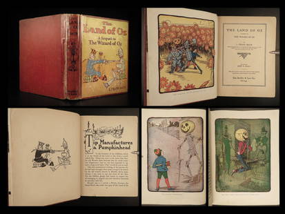
Sold2017Marvelous Land of Oz First EditionHeading: Author: Baum, L. Frank Title: The Marvelous Land of Oz Place Published: Chicago Publisher:Reilly & Britton Date Published: 1904 Description: 287 pp. Illustrated wiSee Sold Price
Sold20241904 The Marvelous Land of Oz L Frank BaumAppears to be First Edition The further adventures of the Scarecrow and Tin Woodman -A Sequel to the Wizard of OzSee Sold Price
Sold2018L. Frank Baum. "The Marvelous Land of Oz"(1904) The Reilly & Britton Co., Chicago, Illustrated by John R. Neill; Private collector, Philadelphia, PASee Sold Price
Sold2022MARVEL COMICS TREASURY HE MARVELOUS LAND OF OZMARVEL COMICS TREASURY HE MARVELOUS LAND OF OZSee Sold Price
Sold20231904 1ed The Land of OZ Frank Baum Wizard of Oz Illustrated Fiction Fantasy1904 1ed The Land of OZ Frank Baum Wizard of Oz Illustrated Fiction Fantasy Were off to see the wizard, the wonderful Wizard of Oz!” The Marvelous Land of Oz was the sequel to the Wizard of Oz,See Sold Price
Sold2018A Collection of Five Easton Press Books by L. FrankA Collection of Five Easton Press Books by L. Frank Baum, 20th Century, Including the titles: 'The Wonderful Wizard of Oz', 'The Marvelous Land of Oz', 'Ozma of Oz', 'The Road to Oz' and 'The EmeraldSee Sold Price
Sold20231904 Land of Oz Sequel to Wizard of Oz L. Frank Baum Marvelous Illustrated1904 Land of Oz Sequel to Wizard of Oz L. Frank Baum Marvelous Illustrated “The Marvelous Land of Oz” or simply, “The Land of Oz” by L. Frank Baum is the sequel to the belovedSee Sold Price
Sold2023Wright, Paul 1782 Folio Holy Land Map. Jerusalem City"A Correct Map of the Antient City of Jersusalem and Parts Adjacent" Folio Copper Engraved Map Published 1782, London for "The Complete British Family Bible…" by Paul Wright. Drawn and Engraved by TSee Sold Price
Sold2023Wright, Paul 1782 Folio Holy Land Map. Canaan & Journeys of the Israelites"A Map of the Land of Canaan according to Sacred History" Folio Copper Engraved Map Published 1782, London for "The Complete British Family Bible…" by Paul Wright. Drawn and Engraved by Thomas CondeSee Sold Price
Sold20201869 Map of the Sacred LandAuthor: Brehier Title: 1869 Map of the Sacred Land Medium: Ink on Paper Dimensions: 18.5"X13" Description: Map of the Sacred Land dated 1869. Double folio map drawn by Brehier. Published by Belin in PSee Sold Price
Sold2016Map of Holy Lands. 1854.Print of hand colored steel engraving .Drawn by L. Dussieux. Engraved by unknown.From „Atlas General De Geographie physique, politique et historique par L. Dussieux. Atlas de Geographie ancienne, duSee Sold Price
Sold2021Findlay, Alex C1835 Antique Map. Tasmania Australia"Van Diemens Land" Steel Engraved Map Published C1835 by Thomas Kelly, London for "A New and Universal English Dictionary" by the Rev. James Barclay. Maps Drawn & Engraved by Alexander Findlay. PaperSee Sold Price
Sold2016Album of the Lands of the Bible - Map of Eretz IsraelAlbum of the lands of the Bible, 50 original views of important places mentioned in scripture, drawn from nature by Johann Martin Bernatz. Stuttgart-Leipzig: J.L. Steinkopf, 1858. English, German andSee Sold Price
Sold20221760 PHILADELPHIA, PA DRAWN PROPERTY SURVEY MAPLAND SURVEYED 1760. SIGNED CHRIS LEHMAN. PROPERTY BELONGING TO THOMAS LIVEZEY. APPROX. 8 1/2" X 12 1/2".See Sold Price
Sold20221785 PA HAND DRAWN SURVEYOR DRAFT MAPDRAFT OF 10 ACRES & 17 PERCHES OF LAND WITHIN THE BLACK LINE WITH THOMAS LIVEZEY BOUGHT FROM PETER HIFELER & BARRET GETZSee Sold Price
Sold20221752 PHILADELPHIA, PA DRAWN PROPERTY SURVEY MAPLAND SURVEYED 1752. SIGNED CHRIS LEHMAN. PROPERTY BELONGING TO THOMAS LIVEZEY.See Sold Price
Sold20171815 South Carolina Land Survey & 1829 DeedPen & ink, hand drawn survey map with coloring, dated July 28, 1815 describing 211 acres on Tiger River in Union District belonging to William Linam, William Lucas and heirs of Jeremiah Hamilton, Esq.See Sold Price
Sold202218th C. WAYNE COUNTY PA DRAWN PROPERTY DRAFT MAPLAND SURVEYED DECEMBER OF 1784, SIGNED BY GEORGE PALMER OF NORTHAMPTON COUNTY, MOUNTED ON CANVASSee Sold Price
Sold2020Williams & Rapkin 1857 Map of British IndiaSteel Engraved Map Published 1857, London for "England's Battles by Sea and Land..." by Lieut-Colonel Williams. Centre fold as published. Drawn and Engraved by J. Rapkin. Paper Size: 13.75 x 10.5 inchSee Sold Price
Sold2020Williams & Rapkin 1857 Map of Northern IndiaSteel Engraved Map Published 1857, London for "England's Battles by Sea and Land..." by Lieut-Colonel Williams. Centre fold as published. Drawn and Engraved by J. Rapkin. Paper Size: 13.75 x 10.5 inchSee Sold Price
Sold2021Rapkin, John 1857 Map of The Crimea. Ukraine RussiaSteel Engraved Map Published 1857, London for "England's Battles by Sea and Land..." by Lieut-Colonel Williams. Centre fold as issued. Drawn & Engraved by John Rapkin. Paper Size: 14 x 10.5 inch (36 xSee Sold Price
Sold2021Rapkin, John 1857 Map of The Crimea. Ukraine RussiaSteel Engraved Map Published 1857, London for "England's Battles by Sea and Land..." by Lieut-Colonel Williams. Centre fold as issued. Drawn & Engraved by John Rapkin. Paper Size: 14 x 10.5 inch (36 xSee Sold Price
Freeman's | Hindman[MAPS & ATLASES]. Manuscript survey report and map of a Virginia estate, August 1872.$150
2 days LeftSchilb Antiquarian Rare Books1790 Life of Jesus Christ Fleetwood Bible ART Miracles Jerusalem MAP Holy Land$185(8 bids)
Freeman's | Hindman[MAPS]. A group of 8, incl. 5 maps of North America, one of the western hemisphere, & 2 engravings.$150
5 days LeftForum AuctionsHanway (Jonas) The Seaman's Christian Friend, Dodsley, 1779 & others, 18th century theology (c.30)£150
Jun 29Trillium Antique Prints & Rare BooksDe Jode, Rare, pub. 1593 - Map of Asia (Tertiae Partis Asiae)$100
Featured4 days LeftJasper52VERY RARE Map of Washington D.C & Georgetown Land Reclamation, From a Supreme Court Exhibit$320
7 hrs LeftTrillium Antique Prints & Rare BooksValentijn - Early Views and Map of Tasmania, Australia; Anthony van Diemen's Land$100
6 days LeftRail & Road AuctionsDiverse Group of Railroad Paper and Photos - Early 1900s N&W Telegrams, W&LE Photos and Yard Maps,$30
1 day LeftCharleston Estate Services Ltd.RARE VINTAGE GREEN GLAZED POTTERY HORSE DRAWN CARRIAGE PLANTER$5(1 bid)
5 days LeftWestmore Galleries and AuctionsNorth America 1771 Colonial Map - 13 Colonies - 20x24$700(2 bids)
6 days LeftLeland LittleHondius and Janssonius's Map of North America, with California as an Island$275(4 bids)
Featured4 days LeftJasper521587 Ortelius Map of Holland -- Hollandiae Antiquorum Catthorum sedis Nova Descriptio, Auctore$440


![[Baum, L. Frank]: 27. [Baum, L. Frank]. Map of the Marvelous Land of Oz. Drawn by Prof. Wogglebug. 9 x 13 inches; creased at folds, lake identification typed in upper right margin, generally sound. [Chicago], circa 192](https://p1.liveauctioneers.com/1352/247108/128155729_1_x.jpg?height=310&quality=70&version=1651853981)


![Haff, James E.; & Dick Martin: 94. Haff, James E.; & Dick Martin. The Magical Countries Surrounding Oz * The Marvelous Land of Oz. Together 2 color maps. 11 x 17 inches; folded. [Chicago], 1970s [75/100]](https://p1.liveauctioneers.com/1352/247108/128155796_1_x.jpg?height=310&quality=70&version=1651853981)


![[MAPS & ATLASES]. Manuscript survey report and map of a Virginia estate, August 1872. (1 of 0)](https://p1.liveauctioneers.com/dist/images/placeholder.jpg?height=282&quality=70)


