Sold20191876 Mitchell Map of Michigan and Wisconsin [verso]Title/Content of Map: 1876 Mitchell Map of Michigan and Wisconsin [verso] Detroit and Milwaukee -- County and Township Map of the States of Michigan and Wisconsin [verso] Plan of Milwaukee [verso] PlaSee Sold Price
Sold20201858 Mitchell Map of Michigan and Wisconsin -- No. 15Title/Content of Map: 1858 Mitchell Map of Michigan and Wisconsin -- No. 15 Map of the States of Michigan & Wisconsin Cartographer: S Mitchell Year/Place: 1858, Philadelphia Size: 10.4 x 16.8 in. A niSee Sold Price
Sold2018Mitchell: Antique Map of Michigan and Wisconsin, 1852Title/Content of Map: 1852 Mitchell Map of Michigan and Wisconsin -- Map of the States of Michigan and Wisconsin Date Printed: 1852, Philadelphia Cartographer: S Mitchell Size: 8.2 x 10.8 in. A very nSee Sold Price
Sold2018Mitchell: Antique Map of Michigan and Wisconsin, 1852Title/Content of Map: 1852 Mitchell Map of Michigan and Wisconsin -- No. 15 Map of the States of Michigan & Wisconsin Date Printed: 1852 Philadelphia Cartographer: S Mitchell / Cowperthwait & Co. SizeSee Sold Price
Sold2018Mitchell: Antique Map of Michigan & Wisconsin, 1870Title/Content of Map: County Map of Michigan and Wisconsin Cartographer: S. A. Mitchell Place & Date: Philadelphia / 1870 Size: 13 3/4" x 11 78" Condition: full color; light overall age toning The beaSee Sold Price
Sold20211858 OLD TINTED MAP, MICHIGAN & WISCONSIN, MITCHELL1858 OLD TINTED MAP, MICHIGAN & WISCONSIN, MITCHELL SCHOOL & FAMILY GEOGRAPHY 1858 OLD TINTED MAP, MICHIGAN & WISCONSIN, MITCHELL SCHOOL & FAMILY GEOGRAPHY Description 1858 Antique Map by S. AugustusSee Sold Price
Sold2019Samuel Augustus Mitchell (1790-1868), "County Map ofSamuel Augustus Mitchell (1790-1868), "County Map of Michigan and Wisconsin," 1866, H. - 12 3/8 in., W. - 15 1/4 in.See Sold Price
Sold20161837 Mitchell Map of Ohio, Indiana, & IllinoisDESCRIPTION: 1837 S. Augustus Mitchell hancolored fold out pocket map of the states of Ohio, Indiana, and Illinois with the settled parts of Michigan. Attached to original portfolio. MEASUREMENTS: 17-See Sold Price
Sold20161846 Mitchell Map of Ohio, Indiana, & IllinoisDESCRIPTION: 1846 S. Augustus Mitchell handcolored fold out pocket map of the states of Ohio, Indiana, and Illinois with the settled parts of Michigan and Wisconsin. Includes original portfolio. MEASUSee Sold Price
Sold20231869 Mitchell Map of US Midwest -- XIV Ohio, Kentucky, Indiana, Illinois, Iowa and Missouri [verso]Title: 1869 Mitchell Map of US Midwest -- XIV Ohio, Kentucky, Indiana, Illinois, Iowa and Missouri [verso] XV Michigan and Wisconsin Cartographer: S Mithchell Year / Place: 1869, Philadelphia Map DimeSee Sold Price
Sold2015Plan of Milwaukee & Lake Michigan by Mitchell, 1881Original steel engraving by Augustus Mitchell, 1881. Map features city streets & railroads. Dimensions: 15” x 12”See Sold Price
Sold20201852 Map of Michigan and WisconsinAuthor: Mitchell Title: 1852 Map of Michigan and Wisconsin Medium: Ink on Paper Dimensions: 11.5"X9.5" Description: Map of Michigan and Wisconsin dated 1852. Engaved by Augustus Mitchell. Part of MitcSee Sold Price
Sold2024Title: County and Township Map of the States of Michigan and Wisconsin Publication Date: c1874Title: County and Township Map of the States of Michigan and Wisconsin Publication Date: c1874 Cartographer: GAMBLE, W. H. Publisher: S. Augustus Mitchell, Jr. Height: 14.5 Width: 20.75 Railroads showSee Sold Price
Sold2020Mitchell Map of Western U.S.*** START PRICE IS THE RESERVE *** [America] MITCHELL, Samuel Augustus (1792-1868). A New Map of Texas, Oregon and California with the Regions Adjoining. Engraving with original hand color, with origiSee Sold Price
Sold2022Mitchell "Map of Texas, Oregon and California, 1846"Mitchell "Map of Texas, Oregon and California with the Regions Adjoining compiled from the most recent authorities Philadelphia, published by S. Augustus Mitchell, Northeast Corner of Market and SevenSee Sold Price
Sold2023Scarce 1845 Mitchell map of Texas with Tanner bordersExtremely scarce 1845 C. S. Williams map of the Republic of Texas from a true first edition of Mitchell's 1846 New Universal Atlas, showing the Carey & Hart decorative borders, which are not found inSee Sold Price
Sold20211832 Mitchell Map of the United States -- Mitchell'sTitle: 1832 Mitchell Map of the United States -- Mitchell's Travellers Guide Through the United States. A Map of the Roads, Distances, Steam Boat & Canal Routes & c. by J.H. Young Cartographer: S MitcSee Sold Price
Sold20171852 S.A. MITCHELL MAP OF THE STATE OF TEXASFramed "Map of the State of Texas, Engraved to Illustrate Mitchell's School and Family Geography", 1852 by S.A. Mitchell (Samuel Augustus Mitchell, Philadelphia, 1790-1868), engraved by J.H. Young, haSee Sold Price
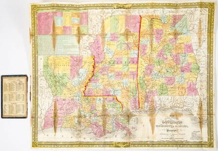
Sold20241835 Mitchell Map Louisiana, Mississippi, Alabama1835 Mitchell Map of Louisiana, Mississippi and Alabama -- Map of the States of Louisiana, Mississippi & Alabama. Cartographer: S Mitchell, 1835, Philadelphia. Map Dimension (in.): 18.25 x 22.625 inchSee Sold Price
Sold20181839 Mitchell Map of the United StatesTitle/Content of Map: 1839 Mitchell Map of the United States -- No. 5 Map of the United States Date Printed: 1839, Philadelphia Cartographer: S Mitchell Size: 10.2 x 16.7 in. This early US map has terSee Sold Price
Sold20231835 Mitchell Map of Louisiana, Mississippi and Alabama -- Map of the States of Louisiana,Title: 1835 Mitchell Map of Louisiana, Mississippi and Alabama -- Map of the States of Louisiana, Mississippi & Alabama Cartographer: S Mitchell Year / Place: 1835, Philadelphia Map Dimension (in.): 1See Sold Price
Sold2024Scarce 1st ed./1st printing of Mitchell map of Mexico/W. IndiesAuthentic first edition/first printing of Samuel A. Mitchell Jr’s Map of Mexico, Central America and the West Indies, with plate number just above title, indicating the rare first state of this map.See Sold Price
Sold20201846 Mitchell Map of Texas -- No. 13 Map of the StateTitle/Content of Map: 1846 Mitchell Map of Texas -- No. 13 Map of the State of Texas Cartographer: S Mitchell Year/Place: 1846, Philadelphia Size: 10.3 X 8 in. This is an excellent map of Texas featurSee Sold Price
Sold20171846 S.A. MITCHELL MAP OF THE STATE OF TEXASFramed "Map of the State of Texas, Engraved to Illustrate Mitchell's School and Family Geography", 1846 by S. Augustus Mitchell (Samuel Augustus Mitchell, Philadelphia, 1790-1868), with notations in aSee Sold Price
1 day LeftJasper521874 Mitchell Map of Texas, Louisiana and Arkansas -- Map of Louisiana, Texas, Arkansas$65
1 day LeftJasper521874 Mitchell Map of Mississippi, Louisiana and Arkansas -- County Map of the States of Arkansas$40
5 days LeftBrunk AuctionsJohn Mitchell - A Map of the British and French Dominions in North America, 1755-1757$24,000
Featured1 day LeftJasper52No. 13 Map of the State of Texas Engraved to Illustrate Mitchell's School and Family Geography$55
3 days LeftSwann Auction GalleriesVARIOUS CARTOGRAPHERS Group of 5 nineteenth-to-twentieth-century maps. 1835-1939.$450
5 days LeftTrillium Antique Prints & Rare BooksLewis - A View of the Butte des Morts Treaty Ground with the arrival of the Commissioners Gov. Lewis$100(1 bid)
5 days LeftTrillium Antique Prints & Rare BooksLewis - Mish-Sha-Quat or the Clear Sky, A Chippeway Chief$100
5 days LeftFontaine's Auction GalleryOriel Cabinet Co. "Norman Suite" Dining Room Set, Grand Rapids, Michigan$18,000
5 days LeftBrunk AuctionsExceptionally Rare Price-Strother Survey of North Carolina Map, c. 1808$60,000
3 days LeftSwann Auction GalleriesHENRY F. WALLING (1825-1889) Map of the City of New York and Its Vicinity. 1866.$1,900


![1876 Mitchell Map of Michigan and Wisconsin [verso]: Title/Content of Map: 1876 Mitchell Map of Michigan and Wisconsin [verso] Detroit and Milwaukee -- County and Township Map of the States of Michigan and Wisconsin [verso] Plan of Milwaukee [verso] Pla](https://p1.liveauctioneers.com/5584/137769/69881333_1_x.jpg?height=310&quality=70&version=1552435690)


![1869 Mitchell Map of US Midwest -- XIV Ohio, Kentucky, Indiana, Illinois, Iowa and Missouri [verso]: Title: 1869 Mitchell Map of US Midwest -- XIV Ohio, Kentucky, Indiana, Illinois, Iowa and Missouri [verso] XV Michigan and Wisconsin Cartographer: S Mithchell Year / Place: 1869, Philadelphia Map Dime](https://p1.liveauctioneers.com/5584/305309/163064973_1_x.jpg?height=310&quality=70&version=1697577828)


![Mitchell Map of Western U.S.: *** START PRICE IS THE RESERVE *** [America] MITCHELL, Samuel Augustus (1792-1868). A New Map of Texas, Oregon and California with the Regions Adjoining. Engraving with original hand color, with origi](https://p1.liveauctioneers.com/1968/163248/82424595_1_x.jpg?height=310&quality=70&version=1583340284)