Sold2022Northern Pacific Land Grant Montana Map c. 1890Featured in this lot is this Northern Pacific land grant Montana Map circa 1890. The map features the plot map of part of Montana and reads as follows: Map Showing Northern Pacific Land Grant in partSee Sold Price
Sold2023Northern Pacific & Great Northern Railway Ephemera Group [168094]Northern Pacific and Great Northern Railway ephemera, into and from Montana, about 20 items. c. 1890-1901. Expense bills, way bills, letterheads, receipts, bill of lading etc.Date: Country (if not USASee Sold Price
Sold2023Northern Pacific Railroad Freight Tariff Ephemera [168149]3 Northern Pacific Railroad Joint Freight Tariff pamphlets. c. 1890, 2x1891. 2 tariff associated agent bulletins c. 1891.Date: Country (if not USA): State: City: Provenance:See Sold Price
Sold2022C. 1890 Helena, Montana Perspective MapFeatured in this lot is this Perspective Map of the City of Helena, Mont. circa 1890. This is a wonderfully and professionally crafted perspective map of the city of Helena, Mont. that shows the citySee Sold Price
Sold2021Blackfoot Fully Beaded Cape Breast Plate c. 1890This is an excellent fully beaded on both sides cape/vest or breast plate attributed to the Blackfoot Native American Indians of Northern Montana, dating to circa 1890. The piece shows a trade tent caSee Sold Price
Sold2023Northern Pacific No. 77470 Freight Car 9-16-55Northern Pacific No. 77470 Freight Car 9-16-55. Provenance: Missoula, Montana Private Collection. Untested, from a lifelong collector who serviced and repaired trains requiring any attention. If lot iSee Sold Price
Sold2021[Vandermaelen, Phillipe M.G.] Montana, Wyoming Map[Vandermaelen, Phillipe M.G.] map of portions of present day Montana, Wyoming, North & South Dakota. Measures 21.75-in. x 29.25-in. sheet size. [Brussells: c.1827]. G/G-VG condition. If lot is absentSee Sold Price
Sold202018th C. Engraved / Colored Map of Central AmericaNorthern Europe, United Kingdom or colonies, ca. 18th to early 19th century CE. An engraved page from a book showing a color map of "Mexico or New Spain" clearly labeled in English. "The Pacific or SoSee Sold Price
Sold2020Nantucket Map, c. 1890Two U.S. geological survey topographical chart maps framed and matted together, showing Nantucket Tuckernuck and Muskeget,c.1890, Overall, 35” x 45”See Sold Price
Sold2024Yellowstone Park Northern Pacific Railroad PosterVery nice original Montana Northern Pacific Railroad Yellowstone National Park Line travel poster. 35" by 45" framed.See Sold Price
Sold2019American Oak Map Case on WheelsAmerican Oak Map Case on Wheels c.1890 twelve drawer case, each having a page from Rand McNally's New Commercial Atlas of America pasted inside; Midwestern states maps showing railroads and steamshipSee Sold Price
Sold2022(RAILROADS.) Jay Cooke & Company (financiers); and The National Railway Publication Company. Map of(RAILROADS.) Jay Cooke & Company (financiers); and The National Railway Publication Company. Map of the Northern Pacific Railroad and Tributary Country. Hand-colored lithographed map of the upper UnitSee Sold Price
Sold2019LOT OF (13) 19TH C. PRESIDENTIAL AUTOGRAPHS & 1771JAMES MADISON Feb 15, 1809 military appointment of Lt Col Electus Backus of the Light Dragoons; JAMES MONROE Nov 8, 1800 land grant to Jules Davenport; JAMES MONROE franked cover to Calender Irvine, CSee Sold Price
Sold2022[WEST FLORIDA] CHESTER, PETER. Three crudely printed land grants for West Florida, each engrossed in[WEST FLORIDA] CHESTER, PETER. Three crudely printed land grants for West Florida, each engrossed in manuscript, with an attached manuscript survey map. Pensacola, Florida, 1st September, 1777; 24 NovSee Sold Price
Sold2022[WEST FLORIDA] CHESTER, PETER. Three crudely printed land grants for West Florida, engrossed in[WEST FLORIDA] CHESTER, PETER. Three crudely printed land grants for West Florida, engrossed in manuscript, each with an attached manuscript survey map. Pensacola, Florida: 11 January, 14 November andSee Sold Price
Sold202119th C. Hawaiian Kou Wood Calabash Bowl**First Time At Auction** North Pacific, Hawaii, ca. 1880 to 1890 CE. A gorgeous calabash bowl, hand-carved from Kou wood to display a round base and thin walls that slant gently inwards to a circularSee Sold Price
Sold2020Ides Travels to China 1706 map & with platesHeading: Author: Ides, Evert Ysbrants Title: Three Years Travels from Moscow Over-land to China: Thro' Great Ustiga, Siriana, Permia, Sibiria, Daour, Great Tartary, &c. to Peking... Place Published:See Sold Price
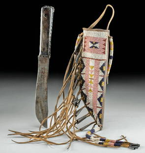
Sold202319th C. Native American Sioux Knife w/ Beaded SheathNative American, North America, Montana, Sioux, ca. 1890 to 1920 CE. A hand-built buffalo leather knife sheath and a forged-steel knife. The singled-edged knife blade features a shallow drop point neaSee Sold Price
Sold2021L.M. Ericsson Skeleton Telephone No. 370/AC100, c. 1890L.M. Ericsson Skeleton Telephone No. 370/AC100, c. 1890 Marked on the transfer-decorated base: "L.M. Ericsson & Co., Stockholm", swiveling microphone support, carbon-pencil transmitter, Bell-type earpSee Sold Price
Sold2016Attributed to Luigi Querena (Italian, 1820 - C. 1890)Attributed to Luigi Querena (Italian, 1820 - C. 1890) Piazza San Marco. Oil on canvas. Unsigned Canvas: 18.5" x 25"See Sold Price
Sold2022Rare Victorian Iron Fence, c. 1890. Approx. 260 feet of fence including gates.Rare Victorian Iron Fence and gates.c. 1890. Approx. 260 ft. includes 30 fence sections, 8 corner posts, 25 connecting posts, 4 gates. Post height 51". Fence height mounted on post 43". Full list andSee Sold Price
Sold20231656 ANNE & HANNAH BRADSTREET LAND GRANT DOCUMENTAnne Bradstreet (née Dudley; March 8, 1612 – September 16, 1672) was the most prominent of early English poets of North America and first writer in England's North American colonies to be pSee Sold Price
Sold2023Tiffany Studios American, Late 19th Century 'Musician in the Cove' Window, c. 1890Tiffany Studios American, Late 19th Century 'Musician in the Cove' Window, c. 1890 stained leaded glass H 73 1/2 x W 44 inches. Property from a Private Collection Provenance: Architectural Archives, ASee Sold Price
2022Blaeu, Johannes (Netherlands, 1596-1673) "The New World Map" Double Hemisphere World Map C. 1664Nova et Accuratissima Totius Terrarum Orbis Tabula Translated "The New World Map", Hand Colored w/ Elaborately Decorated Spandrels.   Sight View 16" x 21-1/2", Overall View 21" x 25-1/2"See Sold Price
2 days LeftLunds Auctioneers & Appraisers Ltd.Northern Plains Beaded Pipe Bag, 21" L, C.1890.CA$400(1 bid)
May 15University ArchivesAndrew Jackson Signs Land Grant for Quarter Section in Southern Illinois$240(1 bid)
2 days LeftJasper521598 Munster Map of Northern Adriatic Coastal Areas -- Sclavonia oder Windisch Marck Bossen Crabaten$140
2 days LeftJasper521877 Adams Chart of Human History -- Adams' Syn Chronical Chart or Map of History$400
May 09Hunt and Peck Estate Services, Inc.1867 United States General Land Office "Rapport af Chefen fur Land-Kontoret i Furenta Saterna."$200
May 16Potter & Potter AuctionsTUNIS, Edward (1897 – 1973). From Chesapeake Bay / Land of ...$250
2 days LeftJasper521886 Adams Chronological Chart of Civilizations -- A Chronological Chart of Ancient, Modern and$550
May 09Hunt and Peck Estate Services, Inc.1784 Captain James Cook "A Voyage to the Pacific Ocean" 2 of 3 volumes$200(1 bid)
2 days LeftJasper52VERY RARE. Washington D.C & Georgetown Land Reclamation. From a Supreme Court Exhibit 1879-1899$480


![Northern Pacific & Great Northern Railway Ephemera Group [168094]: Northern Pacific and Great Northern Railway ephemera, into and from Montana, about 20 items. c. 1890-1901. Expense bills, way bills, letterheads, receipts, bill of lading etc.Date: Country (if not USA](https://p1.liveauctioneers.com/2699/291513/154445715_1_x.jpg?height=310&quality=70&version=1686016442)
![Northern Pacific Railroad Freight Tariff Ephemera [168149]: 3 Northern Pacific Railroad Joint Freight Tariff pamphlets. c. 1890, 2x1891. 2 tariff associated agent bulletins c. 1891.Date: Country (if not USA): State: City: Provenance:](https://p1.liveauctioneers.com/2699/291513/154445712_1_x.jpg?height=310&quality=70&version=1685892308)


![[Vandermaelen, Phillipe M.G.] Montana, Wyoming Map: [Vandermaelen, Phillipe M.G.] map of portions of present day Montana, Wyoming, North & South Dakota. Measures 21.75-in. x 29.25-in. sheet size. [Brussells: c.1827]. G/G-VG condition. If lot is absent](https://p1.liveauctioneers.com/5755/206309/104802119_1_x.jpg?height=310&quality=70&version=1622662726)


![[WEST FLORIDA] CHESTER, PETER. Three crudely printed land grants for West Florida, each engrossed in: [WEST FLORIDA] CHESTER, PETER. Three crudely printed land grants for West Florida, each engrossed in manuscript, with an attached manuscript survey map. Pensacola, Florida, 1st September, 1777; 24 Nov](https://p1.liveauctioneers.com/292/250642/130213766_1_x.jpg?height=310&quality=70&version=1654271664)
![[WEST FLORIDA] CHESTER, PETER. Three crudely printed land grants for West Florida, engrossed in: [WEST FLORIDA] CHESTER, PETER. Three crudely printed land grants for West Florida, engrossed in manuscript, each with an attached manuscript survey map. Pensacola, Florida: 11 January, 14 November and](https://p1.liveauctioneers.com/292/250642/130213768_1_x.jpg?height=310&quality=70&version=1654271664)