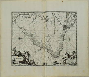
Sold20231671 Ogilby Map of Brazil -- BrasiliaTitle: 1671 Ogilby Map of Brazil -- Brasilia Cartographer: J Ogilby Year / Place: 1671, London Map Dimension (in.): 11.3 X 13.8 in. This is an excellent map of the eastern part of Brazil. There is anSee Sold Price
Sold20231671 Ogilby Map of Panama and Northern South America -- Terra Firma et Novum Regnum Granatense etDescriptionTitle: 1671 Ogilby Map of Panama and Northern South America -- Terra Firma et Novum Regnum Granatense et PopayanCartographer: J OgilbyYear / Place: 1671, LondonMap Dimension (in.): 11.3 X 1See Sold Price
Sold2017H. Moll: Rare Antique Map of Carolina, 1746Title/Content of Map: Carolina's Rare & important Map Date Printed: 1746 Cartographer: Thomas Salmon & Herman Moll Material/Medium: Paper Size: 14 1/2" x 8 1/2" Copperplate engraved. Published in LondSee Sold Price
Sold20201671 Montanus/Ogilby Map of Chile -- ChiliTitle/Content of Map: 1671 Montanus/Ogilby Map of Chile -- Chili Cartographer: Montanus/Ogilby Year/Place: 1671, London Size: 11.2 X 14.2 in. This is a very attractive map covering the coastal regionSee Sold Price
Sold2023Ogilby / Montanus Map of the AmericasOGILBY, John (1600-1676) / MONTANUS, Arnoldus (c. 1625–1683). Insulae Americanae in Oceano Septentrionali cum Terris adiacentibus. Engraved map. London, 1671 (Second state). 16" x 20 1/2" sheet, 33"See Sold Price
Sold2022British road maps.- Ogilby (John) The Roads fromNO RESERVE British road maps.- Ogilby (John) The Roads from Chelmsford in Essex to St. Edmonds-Bury in Suffolk & Saffron-Walden in Essex, strip road map, engraving with hand-colouring, on thin laid paSee Sold Price
Sold2023Scarce 1817 Edgefield Dist., S. Carolina map - 1897Scarce 1897 reprint of the extremely rare 1817 Thos. Anderson map. From the 1897 book by John Abney Chapman which is usually found without the map. The 1817 map is the genesis for the 1825 map found iSee Sold Price
Sold20221675 Ogilby Road Map from London to Flambourough HeadTitle: 1675 Ogilby Road Map from London to Flambourough Head -- The Road from London to Flambourough Head in Com Ebor… Cartographer: J Ogilby Year / Place: 1675, London Map Dimension (in.): 13.4 X 1See Sold Price
Sold20231832 HINTON SIMPKIN & MARSHALL N&S CAROLINA MAP1832 HINTON SIMPKIN & MARSHALL N&S CAROLINA MAP Map of North and South Carolina engraved and printed by Ferrier Sears & Co., published by J.T. Hinton, Simpkin & Marshall in London, dated 1832.See Sold Price
Sold2017Bellin: Antique Map of Carolina & Georgia, 1757Map: Carte de la Caroline et Georgie Cartographer: Bellin Place & Date: Paris / 1757 Size: 11 1/8" x 7 3/8" Condition: b&w Bellin's highly detailed map of Georgia and the Carolinas with an elegant titSee Sold Price
Sold2017Moxon: Geo-religious Map of the Ancient World, 1671Map: Totius Orbis Terrarum Tabula, Eiusque Post Diluvium Divisio Inter Filios Noachi Cartographer: J. Moxon Place & Date: London / 1671 Size: 13" x 8" Condition: outline color; overall age toning A faSee Sold Price
Sold20191867 NORTH + SOUTH CAROLINA MAPOriginal antique map of North and South Carolina published by S. Augustus Mitchell, Jr. Includes inset maps of Charleston Harbor in the bottom left and a Plan of Charleston in the bottom right. It feaSee Sold Price
Sold2021Charleston South Carolina mapCharleston South Carolina map surveyed by Charles Vignoles & Henry Ravenel 1820 I proved for mills atlas 38 inches x 35 inchesSee Sold Price
Sold2018Pre Civil War South Carolina Map Charleston 1847Original hand colored map in overall good condition. Not a repro or restrike. Recently matted and framed using conservation materials. Framed dimensions 23 x 19 inches.See Sold Price
Sold2017Montanus / Ogilby: Antique Map of Central America, 1671Map: Yucatan . . . et Guatimala Cartographer: Montanus / Ogilby Place & Date: Amsterdam / 1671 Size: 14 1/4" x 11 1/4" Condition: b&w; overall age toning and some spotting The detailed map of southeasSee Sold Price
Sold2021Soil Map. South Carolina Darlington SheetPublication Date: 1902 Title: Soil Map. South Carolina Darlington Sheet Cartographer: RICE, T. D. / F. W. TAYLOR Publisher: U.S. DEPARTMENT OF AGRICULTURE. (BUREAU OF SOILS) Height: 30.6 Width: 34 ColSee Sold Price
Sold2019Montanus / Ogilby: Antique Map of Central America, 1671The detailed map of southeastern Mexico and Central America from Ogilby's English edition of Montanus' influential history of America. The map encompasses the Mexican heartland, the Yucatan peninsula,See Sold Price
Sold2022Antique South Carolina Map with Plan of CharlestonMid to late 19th century (1850-1890). Perhaps a little older. Matted size is 21 x 14 inches.See Sold Price
Sold20211895 North Carolina MapAuthor: Cram Title: 1895 North Carolina Map Medium: Ink on Paper Dimensions: 22.5"X14.5" Description: Map of North Carolina dated 1895. Printed by George Cram for Walker's International Atlas. PublishSee Sold Price
Sold20231891 Mitchell Map of Maryland, Virginia, North Carolina and South Carolina -- Map of Maryland,Title: 1891 Mitchell Map of Maryland, Virginia, North Carolina and South Carolina -- Map of Maryland, Virginia, North Carolina and South Carolina Cartographer: S Mitchell Year/Place: 1891, PhiladelphiSee Sold Price
Sold2017Colton: Antique Pre Civil War Map South Carolina, 1861Title/Content of Map: Pre Civil War South Carolina by Colton Date Printed: 1861 Cartographer: J.H. Colton Material/Medium: Paper Size: 17 1/2" x 14" Hand colored steel engraved Map from 'Colton's GeneSee Sold Price
Sold20211886 North Carolina MapAuthor: Cram Title: 1886 North Carolina Map Medium: Ink on Paper Dimenions: 13.5"X11" Description: Map of North Carolina dated 1886. Printed and published by George Cram in Chicago. Key lower left. WiSee Sold Price
Sold20211885 North Carolina MapAuthor: Watson Title: 1885 North Carolina Map Medium: Ink on Paper Dimensions: 13.5"X11" Map of North Carolina dated 1885. Printed and published by Watson in Chicago. Part of his World Atlas. Key loweSee Sold Price
Sold2021Pender County North Carolina mapPender County North Carolina state highway commission map, US Department of commerce Bureau of public roads state wide highway planning survey from January 1, 1961, size is 19“ x 31“ in very goodSee Sold Price
7 days LeftBlackstone Valley Auctions & Estates LLCRevolutionary Era War Map of the Attack on Ft. Moultrie.$200(2 bids)
3 days LeftJasper521671 MAP VENEZUELA CUM PARTE AUSTRALI NOUAE ANDALUSIAE antique 15x18" 17th CENT.$200
6 days LeftTrillium Antique Prints & Rare BooksCatesby, Folio - Brown Moth with Maho (Cork Tree). 2-90$200
6 days LeftTrillium Antique Prints & Rare BooksCatesby, Folio - Mangrove Grape Tree with Goldenrod Moth. 2-96$200
6 days LeftTrillium Antique Prints & Rare BooksCatesby, Folio - Horned Caterpillar with Pigeon Plum. 2-94$200
6 days LeftTrillium Antique Prints & Rare BooksCatesby, Folio - Rattlesnake (Canebrake Rattlesnake). 2-41$200
3 days LeftFleischer's Auctions[Confederate] Sword & Effects of North Carolina Officer $2,700(11 bids)
2 days LeftFleischer's Auctions1755 Map Partie de l'Amerique Septentrionale, qui comprend Le Cours de L'Ohio...$200(3 bids)
15 hrs LeftSchilb Antiquarian Rare Books1977 JRR Tolkien 1st ed 1st Printing Silmarillion Lord of the Rings + MAP + DJ$210(6 bids)
15 hrs LeftSchilb Antiquarian Rare Books1883 FLORIDA for Tourists & Settlers Illustrated Fort Barrancas MAP Fine BINDING$90(5 bids)
15 hrs LeftSchilb Antiquarian Rare Books1859 AFRICA VOYAGES Barth Timbuktu Tripoli SLAVES Illustrated Slavery MAP African$105(5 bids)


![[Confederate] Sword & Effects of North Carolina Officer (1 of 16)](https://p1.liveauctioneers.com/7226/325455/175169159_1_x.jpg?height=282&quality=70&version=1712370394)

![[Confederate] Portrait of North Carolina Officer (1 of 2)](https://p1.liveauctioneers.com/7226/325455/175169161_1_x.jpg?height=282&quality=70&version=1712370394)


![[Gettysburg POW] 57th North Carolina Portrait (1 of 2)](https://p1.liveauctioneers.com/7226/325455/175169163_1_x.jpg?height=282&quality=70&version=1712370394)


![[CIVIL WAR] Libby POW & Carolina Campaign Diary (15th CT) (1 of 4)](https://p1.liveauctioneers.com/7226/325455/175169052_1_x.jpg?height=282&quality=70&version=1712370394)


