Sold2020Pre-Civil War Map of Texas, J. H. Young 1858Map of Texas by J. H. Young issued in a Mitchell school atlas not long after Texas assumed its current boundaries. Most of the towns were still in the east but there were some western settlements. TheSee Sold Price
Sold2017Colton: Antique Pre Civil War Map South Carolina, 1861Title/Content of Map: Pre Civil War South Carolina by Colton Date Printed: 1861 Cartographer: J.H. Colton Material/Medium: Paper Size: 17 1/2" x 14" Hand colored steel engraved Map from 'Colton's GeneSee Sold Price
Sold20191858 Mitchell Map of Texas -- No. 13 Map of the StateTitle/Content of Map: 1858 Mitchell Map of Texas -- No. 13 Map of the State of Texas Date: 1858, PhiladelphiaCartographer: S Mitchell Size: 8 x 10.4 in. A nice pre-Civil War map of Texas. Great deal oSee Sold Price
Sold2017Young: Antique Pre Civil War Map of Virginia, 1851Title/Content of Map: Pre Civil War rare Tourist Map of Virginia Date Printed: 1851-1859 Cartographer: J. Young Material/Medium: Paper Size: 16" x 13 1/2" Condition: Excellent Hand colored. A rare PocSee Sold Price
Sold2020Scarce Cowperthwait, Desilver, Butler map of TexasScarce map of Texas by J.H. Young. “Map of the State of Texas from the Latest Authorities by J. H. Young.” 1850 map from an early 1855 edition of the Cowperthwait, Desilver & Butler New UniverSee Sold Price
Sold20182 Colton Civil War Maps, Military Stations & Forts, 3Two (2) Colton Civil War maps, 3 items total. 1st item: J.H. Colton, Civil War era map of the United States showing Military Stations and Forts, prepared for The Rebellion Record, New York: G.P. PutnaSee Sold Price
Sold20191858 Mitchell Map of United States -- No. 5 Map of theTitle/Content of Map: 1858 Mitchell Map of United States -- No. 5 Map of the United States Date: 1858, PhiladelphiaCartographer: S Mitchell Size: 10.6 X 17 in. A nice double page pre-Civil War map ofSee Sold Price
Sold20191858 Mitchell Map of North America -- No 4 Map of NorthTitle/Content of Map: 1858 Mitchell Map of North America -- No 4 Map of North America Date: 1858, PhiladelphiaCartographer: S Mitchell Size: 10.4 X 8.2 in. A nice pre-Civil War map of North America, fSee Sold Price
Sold20191858 Mitchell Map of New England -- No. 8 Map of theTitle/Content of Map: 1858 Mitchell Map of New England -- No. 8 Map of the New England or Eastern States Date: 1858, PhiladelphiaCartographer: S Mitchell Size: 17 x 10.6 in. A nice pre-Civil War map oSee Sold Price
Sold2022Civil War CDV of Soldier With Flintlock MusketCarte de visite photograph of a full standing view of Civil War soldier wearing 4-button jacket, kepi and holding flintlock musket. Image presents backmark of J.H. Young, Baltimore St., Baltimore. CarSee Sold Price
Sold2022(CIVIL WAR--TEXAS.) A wounded Confederate's request for light duty, bounced up for the signatures of(CIVIL WAR--TEXAS.) A wounded Confederate's request for light duty, bounced up for the signatures of two Major Generals. Autograph Letter Signed by Captain J.H. Rambo to Colonel S.S. Anderson, and addSee Sold Price
Sold20231842 MATHER & SMITH WALL MAP OF LONG ISLAND, NYHand-colored lithograph. "A Geological Map of Long & Staten Islands with the Environs of New York"; William W. Mather, geologist and J. Calvin Smith, surveyor. This landmark pre-Civil War map is the eSee Sold Price
Sold2024Great vintage RR map of N. Carolina from scarce Colton atlasExcellent map of North Carolina just one year after being readmitted to the Union following the Civil War. The map was originally created in 1855 by J. H. Colton from a larger wall map, then updated aSee Sold Price
Sold2022Early Nineteenth Century Map of Texas.Early 19th century hand colored map of Texas published by C.S. Williams, NE Corner of Market and 7th St., Philadelphia, 1845. Map engraved by J.H. Young exhibits previous folds and has been laid down.See Sold Price
Sold2021J. H. Young map of Virginia by CowperthwaitAttractive and desirable map of Virginia eight years before West Virginia broke off and became its own state. These pre-West Virginia maps of Virginia are fascinating and are sought after by collectorSee Sold Price
Sold20171852 S.A. MITCHELL MAP OF THE STATE OF TEXASFramed "Map of the State of Texas, Engraved to Illustrate Mitchell's School and Family Geography", 1852 by S.A. Mitchell (Samuel Augustus Mitchell, Philadelphia, 1790-1868), engraved by J.H. Young, haSee Sold Price
Sold2020CSA Gen. Benjamin J. Hill Buys a Negro Slave Boy!Black History Confederate States Brigadier General Benjamin Jefferson Hill of Tennessee Buys a Negro Slave Boy Named "Henry"! December 15, 1858-Dated Pre Civil War, Manuscript Slave Bill of Sale DocumSee Sold Price
Sold2018Signed: Young. Confederate Wizards Of The Saddle[Civil War] Bennett H. Young. Confederate Wizards Of The Saddle. Signed and inscribed by the author on title page. Bos: Chapple Publishing, 1914. Many portraits, maps, other illustrations. 8vo. Red clSee Sold Price
20231859 Map of Florida by ColtonTitle: 1859 Map of Florida by Colton Date/Period: 1859 Materials: Steel engraved Size: 17 1/2 x 14 1/2” Florida with Florida keys in the insert. From before the civil war. By J. H. Colton & G. WSee Sold Price
Sold20231859 Map of Florida by ColtonTitle: 1859 Map of Florida by Colton1859 Materials: Steel engraved Size: 17 1/2 x 14 1/2” Florida with Florida keys in the insert. From before the civil war. By J. H. Colton & G. W. Colton. From "GeSee Sold Price
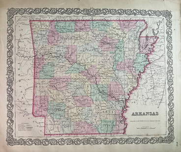
Sold20231859 Map of Arkansas by ColtonTitle: 1859 Map of Arkansas by Colton Date/Period: 1859 Materials: Steel engravedSize: 17 1/2 x 14 1/2” Arkansas. From before the civil war. By J. H. Colton & G. W. Colton. From "General Atlas".See Sold Price
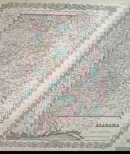
Sold20231859 Map of Alabama by ColtonTitle: 1859 Map of Alabama by Colton Date/Period: 1859 Materials: Steel engravedSize: 17 1/2 x 14 1/2” Alabama. From before the civil war. By J. H. Colton & G. W. Colton. From "General Atlas". PSee Sold Price
Sold20181 Gallon Ovoid Crockca 1840, impressed mark J. Miller Wheeling, VA. Very minor glaze wear, otherwise excellent condition. Only a few pots are known for this pre Civil War West Virginia potter. 8 1/2" h x 6" at widest poiSee Sold Price
Sold2020Johnson’s 1862 map of TexasA. J. Johnson's highly desirable map of Texas. Large and detailed map based on J. de Cordova's map of 1849, by way of Colton's map of 1855, Produced at the height of the American Civil War, this beautSee Sold Price
May 15University ArchivesLincoln Brady Photo Study for Carpenter's "First Reading of the Emancipation Proclamation," Meserve $100(1 bid)
May 14Fleischer's AuctionsLincoln's Funeral Cortège Book by Custodian of Lincoln's Tomb$150(2 bids)
Jun 02Schilb Antiquarian Rare Books1866 Women of the Civil War 1ed Americana Gettysburg Military Robert E Lee Moore$1(1 bid)
May 09Weatherham Estate TreasuresAbraham Lincoln Bronze Bust Sculpture On Marble Base - Signed Original - 10lbs$400
Jun 02Schilb Antiquarian Rare Books1874 Confederate 1ed General Joseph E Johnston Civil War Narrative CSA Military$1
May 14Fleischer's Auctions[LINCOLN] 1864 California National Union Ticket "Rally Round the Boys!"$225(2 bids)
May 15University Archives"For President Jefferson Davis" Possibly Unique Ballot Totals from Georgia$750
3 days LeftThe Written Word AutographsGardner,Alexander Civil War Photographer Very RARE Signed Check$1,500


![Signed: Young. Confederate Wizards Of The Saddle: [Civil War] Bennett H. Young. Confederate Wizards Of The Saddle. Signed and inscribed by the author on title page. Bos: Chapple Publishing, 1914. Many portraits, maps, other illustrations. 8vo. Red cl](https://p1.liveauctioneers.com/179/122672/62427998_1_x.jpg?height=310&quality=70&version=1527272450)


![[BUTTRE, J. C. (1821-1893), engraver]. Abraham Lincoln. [Ne... (1 of 1)](https://p1.liveauctioneers.com/928/328184/176813626_1_x.jpg?height=282&quality=70&version=1714496988)


![[LINCOLN] 1864 California National Union Ticket "Rally Round the Boys!" (1 of 1)](https://p1.liveauctioneers.com/7226/322253/173251604_1_x.jpg?height=282&quality=70&version=1710004847)
![[RE LEE] Signed Photograph & Letter To Namesake (1 of 3)](https://p1.liveauctioneers.com/7226/325455/175169169_1_x.jpg?height=282&quality=70&version=1712370394)


![[Gettysburg POW] 57th North Carolina Portrait (1 of 2)](https://p1.liveauctioneers.com/7226/325455/175169163_1_x.jpg?height=282&quality=70&version=1712370394)


