Sold2020Rollin, Charles 1780 Map of The Black Sea/Mediterranean"The Retreat of the Ten Thousand" Copper Engraved Map Published 1780, London for "The Ancient History..." by Charles Rollin. Folds as issued. Paper Size: 12.5 x 10 inch (32 x 26cm) Minor offsetting anSee Sold Price
Sold2020Rollin, Charles 1780 Map of Arabia, Armenia, Black Sea"Alexander's Expedition" Copper Engraved Map Published 1780, London for "The Ancient History..." by Charles Rollin. Folds as issued. Paper Size: 17.5 x 10.5 inch (25 x 22cm) Minor offsetting and toninSee Sold Price
Sold2020Rollin, Charles 1780 Map of Old FranceCopper Engraved Map Published 1780, London for "The Ancient History..." by Charles Rollin. Folds as issued. Paper Size: 8.5 x 6 inch (22 x 16cm)See Sold Price
Sold2020Rollin, Charles 1780 Map of Armenia, Holy Land, Caspian"History of the Assyrians, Babylonians, Medes and Persians" Copper Engraved Map Published 1780, London for "The Ancient History..." by Charles Rollin. Folds as issued. Paper Size: 17.5 x 10.5 inch (25See Sold Price
Sold2020Rollin, Charles 1780 Map of Syracuse, Sicily ItalyCopper Engraved Map Published 1780, London for "The Ancient History..." by Charles Rollin. Fold as issued. Paper Size: 8.5 x 6 inch (22 x 16cm)See Sold Price
Sold2020Rollin, Charles 1780 Map of The Holy Land"Chart of the Expedition of Cyrus..." Copper Engraved Map Published 1780, London for "The Ancient History..." by Charles Rollin. Folds as issued. Paper Size: 15 x 9.5 inch (38 x 24cm) Several closed tSee Sold Price
Sold2020Rollin, Charles 1780 Map of North Africa"The Carthaginian Empire in Africa" Copper Engraved Map Published 1780, London for "The Ancient History..." by Charles Rollin. Folds as issued. Paper Size: 19 x 9.5 inch (48 x 24cm) Very minor toning.See Sold Price
Sold2020Rollin, Charles 1780 Map of Italy"Expedition of Hannibal wherein his Passage into Italy" Copper Engraved Map Published 1780, London for "The Ancient History..." by Charles Rollin. Folds as issued. Paper Size: 20 x 12 inch (50 x 30cm)See Sold Price
Sold2023Rollin & d'Anville 1780 Map. Alexander's ExpeditionCopper Engraved Map Published 1780, London for "The Ancient History..." by Charles Rollin.Folds as issued. Paper Size: 17.5 x 11.5 inch (43 x 29cm) Heavy toning/offsetting present.See Sold Price
Sold2023Rollin, d'Anville & Kitchen 1780 Map. Greece with the Northern ProvincesCopper Engraved Map Published 1780, London for "The Ancient History..." by Charles Rollin.Folds as issued. Paper Size: 11 x 9 inch (28 x 23cm) Minor toning/offsetting present, otherwise fineSee Sold Price
Sold2023Rollin & d'Anville 1780 Map of the Retreat of the Ten ThousandCopper Engraved Map Published 1780, London for "The Ancient History..." by Charles Rollin.Folds as issued. Paper Size: 13 x 10.5 inch (33 x 27cm) Heavy toning/offsetting present.See Sold Price
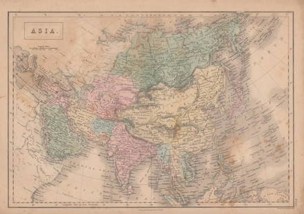
Sold2017Adam & Charles Black: Map of Asia, 1854Map of Asia. Adam and Charles Black 1854, 17.25 x 12.5 inches Please note that this lot has a confidential reserve. When you leave a bid in advance of the auction, submit your maximum. Jasper52 will bSee Sold Price
Sold2017Adam & Charles Black: Map of Canada, New Brunswick 1854Map of Canada, New Brunswick &c. Adam and Charles Black 1854, 17.25 x 12.5 inches Please note that this lot has a confidential reserve. When you leave a bid in advance of the auction, submit your maxiSee Sold Price
Sold2022Rollin & d'Anville 1744 Map of ItalyCopper Engraved Map Published 1739-44, London for "TheRoman History From The Foundation of Rome to The Battle of Actium that is to the end of The Commonwealth" by Charles Rollin. Maps Engraved by R. WSee Sold Price
Sold2022Rollin & d'Anville 1744 Map of Numidia, N. AfricaCopper Engraved Map Published 1739-44, London for "TheRoman History From The Foundation of Rome to The Battle of Actium that is to the end of The Commonwealth" by Charles Rollin. Maps Engraved by R. WSee Sold Price
Sold2022Rollin & d'Anville 1744 Map of Syracuse, Sicily ItalyCopper Engraved Map Published 1739-44, London for "TheRoman History From The Foundation of Rome to The Battle of Actium that is to the end of The Commonwealth" by Charles Rollin. Maps Engraved by R. WSee Sold Price
Sold2022Rollin & d'Anville 1744 Map of Numidia, N. AfricaCopper Engraved Map Published 1739-44, London for "TheRoman History From The Foundation of Rome to The Battle of Actium that is to the end of The Commonwealth" by Charles Rollin. Maps Engraved by R. WSee Sold Price
Sold2022Rollin & d'Anville 1744 Map of Gaul, FranceCopper Engraved Map Published 1739-44, London for "TheRoman History From The Foundation of Rome to The Battle of Actium that is to the end of The Commonwealth" by Charles Rollin. Maps Engraved by R. WSee Sold Price
Sold20232 Antique Framed Black & White Block Maps Dated 1780 & 17842 Antique Framed Black & White Block Maps Dated 1780 & 1784. 17 1/4" X 12 3/4" ALL DESCRIPTIONS AND ANY CONDITION STATEMENT GIVEN BY LANGSTON AUCTION GALLERY ARE STRICTLY OPINIONS AND LANGSTON'S SHALLSee Sold Price
Sold2017The Solar System, Theory of the Seaons Map, 1885The Solar System, Theory of the Seaons Map. Adam and Charles Black, 1885, 18 x 13 inches No Reserve: This lot starts at $1 and has no reserve as a courtesy so that collectors can determine the true maSee Sold Price
Sold2017The Solar System, Theory of the Seaons Map, 1854The Solar System, Theory of the Seaons Map. Adam and Charles Black, 1854, 18 x 13 inches No Reserve: This lot starts at $1 and has no reserve as a courtesy so that collectors can determine the true maSee Sold Price
Sold2017Sweden & Norway MapSweden & Norway Map. Adam and Charles Black, 1854, 13 x 18 inches No Reserve: This lot starts at $1 and has no reserve as a courtesy so that collectors can determine the true market value on this authSee Sold Price
Sold2022A Plan of Charles Town the Capital of South Carolina… Charleston. LODGE 1780 mapTITLE/CONTENT OF MAP: 'A Plan of Charles Town the Capital of South Carolina, with the Harbour, Islands and Forts; the Attack on Fort Sulivan, by His Majesty's Ships under Sir Peter Parker, in 1776; thSee Sold Price
Sold2017Black: Map of Persia, Afghanistan & Beloochistan, 1885Map: Persia, Afghanistan & Beloochistan Maker: Adam and Charles Black Date: 1885 From Black's "General Atlas of the World" Size: 17.75 x 13 inches Please note that this lot has a confidential reserve.See Sold Price
May 23Christie'sA LOUIS XVI ORMOLU-MOUNTED AND BRASS-INLAID AMARANTH AND EBONY COMMODE A VANTAUXPreview Only
May 25Cain Modern AuctionsSet of 4 Serving Trays in Lucite & Nickel by Charles Hollis Jones, USA 1968$1,600