Sold20231881 Map of Utah & Nevada by Mitchell1881 Map of Utah & Nevada by Mitchell. Overall size 22 1/2"h x 29 1/2"wSee Sold Price
Sold20201892 Cowles Civil War Map of Utah, Nevada and Most ofTitle: 1892 Cowles Civil War Map of Utah, Nevada and Most of California plus March Route of the Army of Tennessee -- Territory and Military Department of Utah…1860 [and] March Routes of Army of TennSee Sold Price
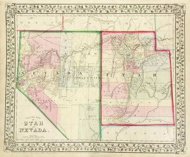
Sold2017Mitchell: Antique County Map of Utah & Nevada, 1870[Utah, Nevada]. N. p: S. Augustus Mitchell, 1870s. The map was drawn and engraved by W. H. Gamble of Philadelphia. Coloured map. Approximately 11-3/4 x 14-/4 inches image area, one sheet, matted. FineSee Sold Price
Sold2019Mitchell: County Map of Utah & NevadaMap Title: County Map of Utah and NevadaCartographer: S. A. Mitchell Place/Date: Philadelphia / 1870 Size: 14" x 11 5/8" Condition: full color; light overall age toning The beautifully detailed and coSee Sold Price
Sold2020USA 1903 Lot of 6 State Maps. California, Utah, NevadaPlus Washington, Colorada and Arizona/New Mexico. Lithograph Maps Published 1903 by Adam & Charles Black, Edinburgh & London for "Encyclopaedia Brittannica" Tenth Edition. Centre fold as published. PaSee Sold Price
Sold2022Nevada & Utah 1880Title/Content of Map: Nevada & Utah 1880 Date Printed: 1880 Material/Medium: paper Size: folio, 23x 15 inches Additional Info: Hand colored county & township map of Utah & Nevada by Mitchell. Map measSee Sold Price
Sold20231877 Mitchell Map of Utah and Nevada [verso] Arizona and New Mexico -- County Map of of Utah andTitle: 1877 Mitchell Map of Utah and Nevada [verso] Arizona and New Mexico -- County Map of of Utah and Nevada [verso] County Map Arizona and New Mexico Cartographer: S Mitchell Year / Place: 1877 PhiSee Sold Price
Sold20191876 Mitchell Map of Utah and Nevada [verso] ArizonaTitle/Content of Map: 1876 Mitchell Map of Utah and Nevada [verso] Arizona and New Mexico -- County Map of of Utah and Nevada [verso] County Map Arizona and New Mexico Date: 1876 Philadelphia CartograSee Sold Price
Sold2023Scarce Johnson map of the Great Western states, 1864Authentic vintage map of California, Utah, Nevada, Colorado, New Mexico, and Arizona. Created during a great time of expansion and change in the western United States while the Civil War was still ragSee Sold Price
Sold2019California Southwest Antique MapEarly map: California, also Utah, Nevada, Colorado, New Mexico and Arizona. Map by A.J. Johnson, New York, c. 1870. 18" x 26 1/2".See Sold Price
Sold2018Mitchell: Antique Map of Utah and Nevada,1870Title/Content of Map: 1870 Mitchell Map of Utah and Nevada -- County Map of Utah and Nevada Date Printed: 1870 Philadelphia Cartographer: S Mitchell Size: 10.6 X 13.5 in. Handsome county map of Utah aSee Sold Price
Sold2020Map of California, Oregon Utah Nevada +Map of California, Oregon, Idaho, Utah, Nevada, Arizona and Washington PLUS Mexico and Central America on verso Two maps on one sheet. (back to back). Hand colored.See Sold Price
Sold2023Scarce Wm. Bradley RR map of the U. S. circa 1894Significant map of the network of railroad lines in the United States from possibly the last American atlas to feature hand-coloring on its maps. Solid red lines represent railroads with dashed linesSee Sold Price
Sold20231855 Beckwith Map of Northern Utah and Nevada -- Map No. 2 From Great Salt Lake to the HumboldtTitle: 1855 Beckwith Map of Northern Utah and Nevada -- Map No. 2 From Great Salt Lake to the Humboldt Mountains from Explorations and Surveys Made Under the Direction of Hon. Jefferson Davis, Sec. ofSee Sold Price
Sold20221855 Beckwith Map of Northern Utah and Nevada -- MapTitle: 1855 Beckwith Map of Northern Utah and Nevada -- Map No. 2 From Great Salt Lake to the Humboldt Mountains from Explorations and Surveys Made Under the Direction of Hon. Jefferson Davis, Sec. ofSee Sold Price
Sold2020LouisianaTitle/Content of Map: Louisiana Cartographer: BRADLEY, WM. M. Date: 1888 Publisher: WM. M. BRADLEY & CO. Size: 22.75Height - 17.1Width Railroads boldly shown. Margin repair. Handsom large scale map ofSee Sold Price
Sold2021Johnson's California Map w/ Territories - Utah,Johnson's California Map w/ Territories - Utah, Colorado, Nevada, etc....21" x 27 1/2"See Sold Price
Sold2017Bradley: Map of Europe, 1888Map of Europe. WM. M. Bradley & Co., 1888. Extremely detailed. Double page. Upper left corner damaged. Folio – 17.60 H x 23.00 W Inches Please note that this lot has a confidential reserve. When youSee Sold Price
Sold2017VINTAGE MAPS AND MOREVINTAGE MAPS - UTAH OIL REFINING COMPANY - WESTERN STATES - SHELL - MAP OF NEVADA/UTAH AND ARIZONA/NEW MEXICO - RPM MOTOR OIL MAP - CALIFORNIA POINTS OF INTEREST AND TOURING MAP - AND MANY MORE - ALLSee Sold Price
Sold2017Colton: Map of California Nevada Utah Colorado ArizonaColton's Map of California, Nevada, Utah, Colorado, Arizona & New Mexico, 1865/1869. Early edition of Colton's map of the Southwestern United States. Unlike in the prior edition, Nevada is no longer tSee Sold Price
Sold2021Bancroft's California, Nevada, etc. 1864Heading: Author: Bancroft, Hubert Howe Title: Bancroft's Map of California, Nevada, Utah and Arizona Place Published: San Francisco Publisher:H.H. Bancroft & Company Date Published: 1864See Sold Price
Sold2021Bancroft's Map of California, Nevada, 1873Heading: Author: Bancroft, Albert Little Title: Bancroft's Map of California, Nevada, Utah and Arizona, Published by A. L. Bancroft & Compy. Booksellers & Stationers San Francisco Cal. 1873 Place PubSee Sold Price
Sold2022Scarce Johnson map of the Great Western states, 1864Antique map of California, Nevada, Utah, Colorado, New Mexico, and Arizona. Published during a great time of expansion and change in the U.S. West, as well as during the Civil War. Here Utah displaysSee Sold Price
Sold2018CubaReserve Reduced! Title/Content of Map: CubaDate: 1888 Cartographer: BRADLEY, WM. M. Material/Medium: WM. M. BRADLEY & BROS. Size: 11 x 14.5 inches Detailed map showing districts, towns, bays, roads, rSee Sold Price
Jun 23Schilb Antiquarian Rare Books1877 Geology Geography Surveys 1ed Nevada Wyoming Utah George Wheeler US West 2v$1
Jun 06Akiba GalleriesAntique Mast, Crowell, & Kirkpatrick Map Of Texas, California, & Nevada$25(1 bid)
2 days LeftJasper521854 EXPLORATION of VALLEY of AMAZON by NAVY DEPARTMENT antique 3 VOLUMES w/MAPS$220
Jun 04The Scanlan CollectionPicturesque California, by John Muir, Volume 3, Imperial Japan Edition$1,000
2 days LeftCedarburg Auction & Appraisals LLCSet of Four 17th Century Maps Showing All of Spain and Portugal$450(2 bids)
2 days LeftCedarburg Auction & Appraisals LLCRare 1877 Double sided map of Milwaukee and Wisconsin$80(6 bids)
Jun 07Freeman's | Hindman[MAP]. TODESCHI, Pietro. [Nova et Acurata Totius Americae Tabula auct. G.I. Blaeu] America quarta$5,000
15 hrs LeftDonny Malone AuctionsWm Gilbert Circa 1910 Mission Oak Arts & Crafts Mantle Clock with Original Key & Pendulum$20(2 bids)
6 days LeftBilly The Kid Auction HouseVintage Navajo Nevada Turquoise Squash Blossom Necklace$300(3 bids)
Jun 08Early American History Auctions1720 Colonial Northumberland County Virginia Manuscript Deed and Map Plot$400


![1892 Cowles Civil War Map of Utah, Nevada and Most of: Title: 1892 Cowles Civil War Map of Utah, Nevada and Most of California plus March Route of the Army of Tennessee -- Territory and Military Department of Utah…1860 [and] March Routes of Army of Tenn](https://p1.liveauctioneers.com/5584/162681/82155385_1_x.jpg?height=310&quality=70&version=1583273475)
![Mitchell: Antique County Map of Utah & Nevada, 1870: [Utah, Nevada]. N. p: S. Augustus Mitchell, 1870s. The map was drawn and engraved by W. H. Gamble of Philadelphia. Coloured map. Approximately 11-3/4 x 14-/4 inches image area, one sheet, matted. Fine](https://p1.liveauctioneers.com/5584/107399/55057774_1_x.jpg?height=310&quality=70&version=1501794677)


![1877 Mitchell Map of Utah and Nevada [verso] Arizona and New Mexico -- County Map of of Utah and: Title: 1877 Mitchell Map of Utah and Nevada [verso] Arizona and New Mexico -- County Map of of Utah and Nevada [verso] County Map Arizona and New Mexico Cartographer: S Mitchell Year / Place: 1877 Phi](https://p1.liveauctioneers.com/5584/293457/155766077_1_x.jpg?height=310&quality=70&version=1687903812)
![1876 Mitchell Map of Utah and Nevada [verso] Arizona: Title/Content of Map: 1876 Mitchell Map of Utah and Nevada [verso] Arizona and New Mexico -- County Map of of Utah and Nevada [verso] County Map Arizona and New Mexico Date: 1876 Philadelphia Cartogra](https://p1.liveauctioneers.com/5584/137769/69881187_1_x.jpg?height=310&quality=70&version=1552435690)


![[BOOKS] COLORADO / ARIZONA. LOT OF 3 VOLUMES (1 of 4)](https://p1.liveauctioneers.com/8124/329546/177689837_1_x.jpg?height=282&quality=70&version=1715469494)


![[MAP]. TODESCHI, Pietro. [Nova et Acurata Totius Americae Tabula auct. G.I. Blaeu] America quarta (1 of 1)](https://p1.liveauctioneers.com/197/329395/177650542_1_x.jpg?height=282&quality=70&version=1715364962)


