Sold2023The World including the late discoveries by Captn Cook… by Thomas BOWEN 1789 mapTITLE/CONTENT OF MAP: 'The World including the late discoveries, by Captn Cook and other circumnavigators carefully laid down to the present time by Thos Bowen' DATE PRINTED: 1789 IMAGE SIZE: Approx 2See Sold Price
Sold2023Three Engraved Maps, including Thomas BowenTHREE ENGRAVED MAPS, including THOMAS BOWEN (Welsh, died 1790), "The World, including the late Discoveries, by Capt. Cook and other Circumnavigators," handcolored engraving on laid paper, plate: 11 1/See Sold Price
Sold2019World map showing latest discoveries, 1778Heading: Author: Bowen, Thomas Title: The World including the late Discoveries by Captn. Cook and other Circum Navigators... Place Published: London Publisher: Date Published: [1778] DSee Sold Price
Sold2020Bowen, Thomas 1789 Map of North America. USA Canada"A New & Accurate Map of North America including Nootka Sound, with the new discovered Islands on the North East Coast of Asia" Copper Engraved Map Published 1789-91 by C. Cooke, London for "The New RSee Sold Price
Sold20231758 Map Chart of World TradewindsAn Accurate Chart of the World with the New Discoveries....Tradewinds.., by Thomas Kitchin, 1758. Large folding map, measures 17 x 13", Condition issues including creasing and repaired breaks at foldsSee Sold Price
SoldPEARY'S COPY OF AN EARLY NORTH AMERICAN MAP. PEARY, ROBERT E. 1856-1920.] DOBBS, ARTHUR. 1689-17...PEARY'S COPY OF AN EARLY NORTH AMERICAN MAP. PEARY, ROBERT E. 1856-1920.] DOBBS, ARTHUR. 1689-1765. A Map of Part of North America From the Latitude of 40 to 68 Degrees, Including the late discoveriesSee Sold Price
Sold202418th CENTURY NEW ENGLAND COASTAL MAPCirca 1763, A New & Accurate Map of North America, including the British Acquisitions gain'd by the late war, in a wood frame h. 7-3/4 w. 9-1/2 in. (sight) overall: 9-3/4 x 11-3/8 in. (frame)ProvenancSee Sold Price
Sold2016T-O World Map.- Lucanus (Marcus Annaeus) Pharsalia,Lucanus (Marcus Annaeus) Pharsalia, manuscript on paper, [Northern Italy (possibly Padua), first half of the fifteenth century]. 294 x 217mm., I + 149 + I leaves (including defective leaves and 3 blanSee Sold Price
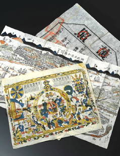
Sold2019China Missions, late 19th century, a small box ofChina Missions, late 19th century, a small box of various China Missionary items and ephemera, including a tissue paper map, passport to Rev. A W Nightingale expiring 1880, signed 'Bullock', printed sSee Sold Price
Sold2022World.- Speed (John) A New and Accurat Map of the World Drawne according to ye truest DescriptionsWorld.- Speed (John) A New and Accurat Map of the World Drawne according to ye truest Descriptions latest Discoveries & best observations yt have beene made by English or Strangers, double-hemisphereSee Sold Price
Sold2024Petrus Plancius, Engraved World MapOrbis Terrarum Typus de Integro Multis in Locis Emendatus. Petrus Plancius (1552-1622). Copper-plate engraving with original hand color in full. Amsterdam, 1594. Some stains, creases, folds. Sight sizSee Sold Price
2022Blaeu, Johannes (Netherlands, 1596-1673) "The New World Map" Double Hemisphere World Map C. 1664Nova et Accuratissima Totius Terrarum Orbis Tabula Translated "The New World Map", Hand Colored w/ Elaborately Decorated Spandrels.   Sight View 16" x 21-1/2", Overall View 21" x 25-1/2"See Sold Price
Sold2018Ortelius' 1570 world mapHeading: Author: Ortelius, Abraham Title: Typus Orbis Terrarum Place Published: Antwerp Publisher: Date Published: 1570-[1584?] Description: Copper-engraved map, hand-colorSee Sold Price
Sold2019WorldTitle/Content of Map: World Date: 1493 Cartographer: Schedel Material/Medium: Woodblock engraving Size: 18x25” The oldest decorative world map that’s obtainable. Map shows 12 wind heads, shows theSee Sold Price
Sold2022Thomas Jefferson Document Signed as Secretary of StateDS, signed "Th: Jefferson," one page, 8 x 13, December 16, 1791. An Act of the Second Congress, in part: "An Act for the relief of David Cook and Thomas Campbell. Be it enacted by the Senate and HouseSee Sold Price
Sold2020Thomas Moran Seascape Painting American 1837-1926Thomas Moran Watercolor signed, dated and titled "OFF THE COAST OF MAINE". Measures 9" x 29" not including the frame. Thomas Moran (1837 - 1926)Thomas Moran was active/lived in Pennsylvania, CaliforniSee Sold Price
Sold2016Leica M3 black paint outfitExtremely rare first owner outfit including a beautiful late production black paint M3 body no.1134105 (B+ condition, in perfect original and good working order, clean finder, perfect vulcanite, 'L' sSee Sold Price
Sold2024Ohio copy of Mathew Carey’s 1796 GENERAL ATLASCarey, Mathew (publisher). CAREY’S GENERAL ATLAS. Philadelphia: Printed by Mathew Carey, May 1, 1796. FOLIO (14.75 x 9.5 inches), COMPLETE AS PUBLISHED (including a Rare Map of The United States bySee Sold Price
Sold2022World: Coin AssortmentWorld: Coin Assortment Including Birth of the Republic of China commemorative coin; 1934 China 'Junk Dollar'; 1933 'Sun Yat Sen' head; as well as the Philippines, Great Britain, France, Australia, SyrSee Sold Price
Sold2023Rare Etruscan Bronze Helmet Montefortino TypeClassical World, Etruria, ca. late 4th to 3rd century CE. A single-cast bronze Montefortino helmet of a domed bowl form with layers of deep, glossy patina and a top knob incised with a layered, scale-See Sold Price
Sold2023A Pair of George III Giltwood and Polychrome Inlaid Marble-Top Pier TablesA Pair of George III Giltwood and Polychrome Inlaid Marble-Top Pier Tables Manner of Thomas Chippendale, Late 18th Century Height 34 x width 35 1/4 x depth 15 3/8 inches. This lot is located in ChicagSee Sold Price
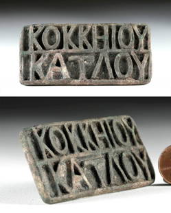
Sold2023Roman Republic Bronze Bread Stamp, Greek LettersClassical World, Greco-Roman, Late Republic Period, ca. 1st century BCE. A cast-bronze bread stamp of a rectangular form with a suspension ring on the verso. The recessed stamp face bears 14 raised GrSee Sold Price
Sold2016JOHN SPEED (BRITISH, 1552-1629) MAP OF THE WORLDJOHN SPEED (BRITISH, 1552-1629) MAP OF THE WORLD, (UPDATED 6/14/16) hand-colored engraving on laid paper, titled "A New and Accurat Map of the World Drawne according to ye truest Descriptions latest DSee Sold Price
Sold2024ASIAN: Four pieces of Chinese porcelain, late Qing Dynasty, including a powder blue baluster formASIAN: Four pieces of Chinese porcelain, late Qing Dynasty, including a powder blue baluster form vase with gilt tracery decoration, a small blue and white crackle ginger jar decorated with boys, andSee Sold Price
5 days LeftJasper52The World including the late discoveries by Captn Cook… by Thomas BOWEN 1789 map$500
Aug 04Schilb Antiquarian Rare Books1977 JRR Tolkien 1st ed 1st Print Silmarillion Lord of Rings Middle Earth + MAP$245(6 bids)
218 Lots AwayKey Date CoinsLot of 5 Japanese WWII Invasion Money "JIM" Notes, Various Countries & Denominations Grades$50
Aug 04Schilb Antiquarian Rare Books1887 History of Minnesota Dakota INDIANS Little Crow Lewis Cass Expedition MAP$56(7 bids)
Aug 03The RSL Auction CompanyRare & Important Pop-Up Panorama Souvenir from the Columbian Exposition$150(1 bid)
10 hrs LeftTrillium Antique Prints & Rare BooksCaptain Cook - Hawaii: An Inland View, in Atooi. 35$75(1 bid)


![World map showing latest discoveries, 1778: Heading: Author: Bowen, Thomas Title: The World including the late Discoveries by Captn. Cook and other Circum Navigators... Place Published: London Publisher: Date Published: [1778] D](https://p1.liveauctioneers.com/642/151690/76551227_1_x.jpg?height=310&quality=70&version=1570486555)


![PEARY'S COPY OF AN EARLY NORTH AMERICAN MAP. PEARY, ROBERT E. 1856-1920.] DOBBS, ARTHUR. 1689-17...: PEARY'S COPY OF AN EARLY NORTH AMERICAN MAP. PEARY, ROBERT E. 1856-1920.] DOBBS, ARTHUR. 1689-1765. A Map of Part of North America From the Latitude of 40 to 68 Degrees, Including the late discoveries](https://p1.liveauctioneers.com/1043/333441/180036747_1_x.jpg?height=310&quality=70&version=1719180533)

![T-O World Map.- Lucanus (Marcus Annaeus) Pharsalia,: Lucanus (Marcus Annaeus) Pharsalia, manuscript on paper, [Northern Italy (possibly Padua), first half of the fifteenth century]. 294 x 217mm., I + 149 + I leaves (including defective leaves and 3 blan](https://p1.liveauctioneers.com/5458/94966/48431616_1_x.jpg?height=310&quality=70&version=1476369049)


![Ortelius' 1570 world map: Heading: Author: Ortelius, Abraham Title: Typus Orbis Terrarum Place Published: Antwerp Publisher: Date Published: 1570-[1584?] Description: Copper-engraved map, hand-color](https://p1.liveauctioneers.com/642/127929/65081054_1_x.jpg?height=310&quality=70&version=1537227236)


![[Thomas Anburey]. Travels Through America (1 of 17)](https://p1.liveauctioneers.com/5755/336176/181789466_1_x.jpg?height=282&quality=70&version=1720647667)


