Sold20181859 Clark & Tackabury Antique Connecticut Wall MapTitle/Content of Map: 1859 Clark & Tackabury Connecticut Wall Map -- Clark & Tackabury's New Topographical Map of the State of Connecticut Date Printed: 1859 Philadelphia Cartographer: Clark and TackaSee Sold Price
Sold20241859 Clark & Tackaburys' Wall Map of ConnecticutAntique 1859 Clark & Tackabury Topographical Wall Map of Connecticut, Coated Paper with Original Rollers. Measures 55 inches x 71 inches. Please note condition issues noted in photography including teSee Sold Price
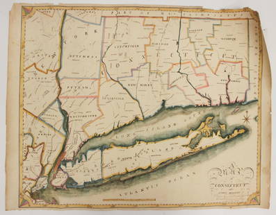
Sold2021Connecticut44. Connecticut.Clark & Tackabury's New Topographical Map of the State of Connecticut. Fine hand-colored map in 24 sections. 56-1/2 x 72 inches, linen-backed, gilt-lettered cloth portfolio with stringSee Sold Price
Sold2018Antique Clark & Tackabury Connecticut Map,1859Antique Clark & Tackabury's, 1859, "New Topographical Map of the State of Connecticut", attached to wooden rod with acorn finials. Note: Complete and very informative colored wall map of Connecticut,See Sold Price
Sold20231845 School Map of the Eastern United States1860 School Map of Connecticut.Clark & Tackaburys' Topographical Map of Connecticut..Map is 69 1/2" x 54 1/2"Condition, rolls up, creases, stains, overall wear, tears, some missing pieces to bottom boSee Sold Price
Sold20231860 School Map of Connecticut1860 School Map of Connecticut. Clark & Tackaburys' Topographical Map of Connecticut.. Map is 69 1/2" x 54 1/2" Condition, rolls up, creases, stains, overallSee Sold Price
Sold20241859 Clark & Hopkins Wall Map Litchfield County CTAntique 1859 Clark & Hopkins Topographical Wall Map of Litchfield County Connecticut, Coated Fabric Backed Paper with Original Rollers. Measures 55 inches x 51 inches. Please note condition issues notSee Sold Price
Sold2022Map of the Town of Cornwall, Connecticut, Circa 1854Map of the Town of Cornwall, Connecticutcirca 1854marked "Map of the Town of Cornwall, Litchfield County, Connecticut, Surveyed & Drawn by L. Fagan, Published by Richard Clark, 42, Moyamensing RoSee Sold Price
Sold2023MAP, Connecticut, ReidConnecticut. John Reid, Connecticut from the Best Authorities, from Winterbotham's History of America, 1796 (circa). Black & White. This early and uncommon map of Connecticut was engraved by BenjaminSee Sold Price
Sold2017Bradford: Antique Map Connecticut & Rhode Island, 1835Title/Content of Map: Connecticut & Rhode Island Date Printed: 1835 Cartographer: T. G. Bradford Material/Medium: Paper Size: 9 1/2" x13" A Comprehensive Atlas Geographical, Historical & Commercial. PSee Sold Price
Sold2020Schoolhouse Map Late 1920s Early 1930s Hearne BrothersSchoolhouse Map Late 1920s Early 1930s Hearne BrothersSee Sold Price
Sold2016RARE (19th c) MASONIC TEMPLE of SOLOMON"A Beautiful and Accurate Elevation of the Temple of Solomon taken from the Celebrated Model erected by Counsellor Schott of Hamburg". Printed and mounted to cloth schoolhouse map configuration. PrintSee Sold Price
Sold2018Bradford: Antique Map of Connecticut, 1838Title/Content of Map: Connecticut by Bradford Date Printed: 1838 Cartographer: Thomas G. Bradford Size: 14" x17" Material/Medium: Paper Provenance: New York A General Atlas of the World with a separatSee Sold Price
Sold2018Tanner: Antique Map of Connecticut, 1843Title/Content of Map: Connecticut by Tanner Date Printed: 1843 Cartographer: based on the work of H.C. Tanner Size: 17" x 14" Material/Medium: Paper Provenance: New York Hand colored engraved Map. FroSee Sold Price
Sold2021Connecticut, 1846, with Hartford & New Haven InsetsTitle/Content of Map: Connecticut, 1846, with Hartford & New Haven Insets Date Printed: 1846, Hildburghausen Cartographer: Joseph Meyer/Bibliographisches Instituts. Size: 14 1/2" 11 3/4" The beautifulSee Sold Price
Sold2018Colton: Antique Map of Connecticut, 1859Title/Content of Map: Connecticut by Colton Date Printed: 1859 Cartographer: H.J. Colton Material/Medium: Paper Size: 17 1/2" x 15" Hand colored,engraved. Published in New York in 'Colton's General AtSee Sold Price
Sold2017Colton: Antique Map of Connecticut, 1861Title/Content of Map: Connecticut by Colton Date Printed: 1861 Cartographer: J.H. Colton Material/Medium: Paper Size: 17 1/3" x 14" Hand colored steel engraved Map from 'Colton's General Atlas'. PubliSee Sold Price
Sold2016Rand, McNally & Co: Connecticut, Rhode Island, 1898Map: Connecticut, Rhode Island Size: 21 x 15 inchesMaker: Rand, McNally & Co Date: 1898From: New Standard Atlas of the World No Reserve: This lot starts at $1 and has no reserve as a courtesy so thatSee Sold Price
Sold2022Early American Map Lewis Clark Major Long US Missouri Arkansas TerritoryTitle: Early American Map Lewis Clark Major Long US Missouri Arkansas Territory Description:Early American Map Lewis Clark Major Long US Missouri Arkansas Territory With some hand coloring. Early GarlSee Sold Price
Sold2023EARLY CONNECTICUT MAPHand drawn and colored; "Connecticut and Parts Adjacent", "drawn by Miss. Elizabeth L. Tredwell" "Christ Church Academy 1820", several edge tears; 23" x 30", F-GSee Sold Price
Sold20221796 Reid Map of Connecticut -- Connecticut from the Best AuthoritiesTitle: 1796 Reid Map of Connecticut -- Connecticut from the Best Authorities Cartographer: J Reid Year/Place: 1796 Dimensions: 13.9 X 17.1 in. Description: This is an excellent, early and uncommon mapSee Sold Price
Sold2023VINTAGE SCHOOLHOUSE WORLD MAP CABINET WITH 18 MAPSLarge wood map case with a sailboat scene on the front door that opens up to hold 18 vintage maps. Each map is on a linen cloth and placed on rollers that display each map. The maps date from the 1930See Sold Price
Sold20161797 AMOS DOOLITTLE CORRECT MAP OF CONNECTICUTEngraved for Dr. Trumbull's History of Connecticut. 14 x 16 1/2 inches.See Sold Price
Sold2023Map of Connecticut And Rhode Island 1780This early map is titled 'A New and accurate Map of Connecticut and Rhode Island. from the best Authorities' published in the Universal Magazine in 1780. The map features Long Island Sound and NarragaSee Sold Price
7 days LeftJasper521864 Johnson Map of Massachusetts, Connecticut and Rhode Island -- Johnson's Massachusetts,$60
19 hrs LeftRapid Estate Liquidators and Auction GalleryUS Post Lewis And Clark First Day Stamp Sheet Bundle$50
May 22Thomaston Place Auction Galleries1857 KANSAS & NEBRASKA HANDBOOK BOUND WITH LIFE OF GEN JOSEPH WARREN$100
May 21Hess Fine Auctions1885 A Popular History Of The United States JC Ridpath Gilt Green Leather Book Illustrated$10