Sold2022Berkshire.- Speed (John) Barkshire Described, engraved map with hand-colouring, [c. 1614]Berkshire.- Speed (John) Barkshire Described, county map with large panorama of Windsor Castle, engraving with hand-colouring, sheet 410 x 535 mm (16 1/8 x 21 in), central vertical fold with minor splSee Sold Price
Sold2022Kent.- Blaeu (Johannes) Cantium Vernacule Kent, engraved map with hand-colouring, [c. 1660].NO RESERVE Kent.- Blaeu (Johannes) Cantium Vernacule Kent, county map, engraving with early hand-colouring, platemark 400 x 530 mm (15 3/4 x 20 3/4 in), sheet 520 x 630 mm (20 1/2 x 24 3/4 in), centraSee Sold Price
Sold201917th century Morden map engravingsTwo 17th century County map engravings by Robert Morden, Hampshire & Monmouth, 37 x 42 cm and 35 x 42 cm respectively, mounted, framed and glazedSee Sold Price
Sold2022Wales.- Speed (John) Glamorgan Shyre; The Countye ofNO RESERVE Wales.- Speed (John) Glamorgan Shyre; The Countye of Monmouth; Breknoke, three welsh county maps, engravings without hand-colouring, on laid papers with grapes watermark, each sheet approx.See Sold Price
Sold2021Antique 1858 Wall Map Berkshire County,MA MassachusettsAntique 1858 Wall Map Berkshire County,MA Massachusetts. This beautiful old map has lots of great details. The dimensions are 63in x 65in x 1.5in. It is in fair/as is condition with all corners worn,See Sold Price
Sold2021Westchester County East to Stateline MapEngravingWestchester County - Yonkers to Dobbs Ferry - East to Stateline Engraving, copyright to lower right reads ‘By Julius Bien & Co. 1890.’, subject a map of the lower half of Westchester County with HSee Sold Price
Sold2020TEXAS MAP ENGRAVING PANHANDLE COUNTIES INSETFramed Texas map, hand-colored engraving on paper, a page from an atlas, plate 68, published by William Bradley, c.1880, an inset with Panhandle counties, within a geometric border, sight: approx 17.5See Sold Price
Sold2023Samuel Augustus Mitchell 'County Map of...GA and AL'A Samuel Augustus Mitchell (American, 1792-1868) hand colored engraving titled 'County Map of the States of Georgia and Alabama' depicting the tri-state area of Georgia, Alabama and part of Florida anSee Sold Price
Sold2024William H. Gamble (American, B. 1863) Hand Colored Engraving, Ca. 1863, "County Map of Michigan AndWilliam H. Gamble (American, B. 1863) Hand Colored Engraving, Ca. 1863, "County Map of Michigan And Wisconsin", H 12" W 14" | Map shows counties, cities and towns in Minnesota and Michigan, mineral reSee Sold Price
Sold2024Vintage County Map Of NY State Plate EngravingMarked on lower left corner drawn and engraved by W.H. Gamble. Geographically map showing the state capitals, county towns, community towns, rail roads and canals in black and white. Framed in a tan tSee Sold Price
Sold2020Map of Berkshire County & Southern Mass.Map of Berkshire County & Southern Mass.See Sold Price
Sold2020Historisch-geographisch- und politische BeschreibungHistorisch-geographisch- und politische Beschreibung der Moldau, by Demetrii Kantemir, Frankfurt, 1771, German book about Moldau county, with engraving and map. Length: 19.5 cm. Good condition (stainsSee Sold Price
Sold2022Sussex.- Jansson (Jan) Suthsexia vernacule Sussex,NO RESERVE Sussex.- Jansson (Jan) Suthsexia vernacule Sussex, map of the county, engraving with later hand-colouring, platemark 385 x 515 mm (15 1/8 x 20 1/4 in), good margins, German text verso, centSee Sold Price
Sold2022English county maps.- Northern England.- Speed (John)NO RESERVE English county maps.- Northern England.- Speed (John) Anno Darbieshire described, county map, inset town plan of Derby and inset view of St Anne's well at Buxton, engraving, 385 x 510 mm (1See Sold Price
Sold2021Hastings Dobbs’ Ferry Irvington Map Engraving 1872Hastings, Dobbs’ Ferry, Irvington Engraving, 1872, no apparent signature, verso reads ‘(40) Original Map Westchester County Atlas, 1872’, subject maps of the towns of Hastings, Dobbs’ Ferry, aSee Sold Price
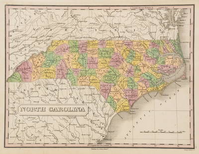
Sold2023Anthony Finley North Carolina Counties MapA Anthony Finley (American, 1784-1834) handcolored engraving depicting the counties within North Carolina and the surrounding areas. Stamped 'Published By A. Finley Phliad.' lower center. Presented inSee Sold Price
Sold2015Carroll & Frederick Counties Map published Atlas ofOriginal engraving published by Stedmann & Brown, 1873. Dimensions: 17" x 14 1/2"See Sold Price
Sold2022Gloucestershire.- Speed (John) Glocestershire contrivedGloucestershire.- Speed (John) Glocestershire contrived into thirty thre several hundreds, county map with inset plan of Bristol and Gloucester, engraving with full hand-colouring, sheet 415 x 525 mmSee Sold Price
Sold2019In Camp & Battle with Washington ArtilleryIn Camp and Battle with the Washington Artillery of New Orleans A narrative of events during the Late Civil War from Bull Run to Appomattox and Spanish Fort. IlSee Sold Price
Sold2017South Carolina County by County Slave CountA complete and authentic issue of Harper’s Weekly, November 23, 1861, 16pp., disbound, VG. From the interior, a 2/3 page engraving, “Map of South Carolina Showing the Proportion of Slaves in EachSee Sold Price
Sold2015Map of Minnesota by Johnson & Ward, 1865Original engraving by Johnson & Ward, 1865. Towns, railroads, topography and more are all clearly presented on this detailed map. Counties shown in contrasting pastel shades. Inset shows Lake SuperiorSee Sold Price
Sold2016United States Map, Density of Population, 1895Original engraving from Atlas of the World by Rand McNally, 1895. Map includes counties, geographical landmarks, streets and population data. Dimensions: 21 1/4" x 14" No Reserve Buyer pays shipping -See Sold Price
Sold2016Map of Maine, 1895Original engraving from Atlas of the World by Rand McNally, 1895. Map includes counties, geographical landmarks, streets and population data. Dimensions: 21 1/4" x 27 1/2" No ReserveSee Sold Price
Sold2016Map of Massachusetts (inset of Boston), Martha'sOriginal engraving from Atlas of the World by Rand McNally, 1895. Map includes counties, geographical landmarks, streets and population data. Dimensions: 21 1/4" x 27 1/2" No Reserve This item ships fSee Sold Price
Jun 30Antique FactoryJOHN SPEED (1552 - 1629), BUCKINGHAM 17th Century Copper Engraving Hand Colored Town Plan Map$200
970 Lots AwayBidhausHermes HERMES Calvi Verso Card Case Nata Vaux Swift Chevre Misor U Engraving Cream White Bicolor Sea$1


![Berkshire.- Speed (John) Barkshire Described, engraved map with hand-colouring, [c. 1614]: Berkshire.- Speed (John) Barkshire Described, county map with large panorama of Windsor Castle, engraving with hand-colouring, sheet 410 x 535 mm (16 1/8 x 21 in), central vertical fold with minor spl](https://p1.liveauctioneers.com/5458/260724/135800521_1_x.jpg?height=310&quality=70&version=1662479034)


![Kent.- Blaeu (Johannes) Cantium Vernacule Kent, engraved map with hand-colouring, [c. 1660].: NO RESERVE Kent.- Blaeu (Johannes) Cantium Vernacule Kent, county map, engraving with early hand-colouring, platemark 400 x 530 mm (15 3/4 x 20 3/4 in), sheet 520 x 630 mm (20 1/2 x 24 3/4 in), centra](https://p1.liveauctioneers.com/5458/260724/135800539_1_x.jpg?height=310&quality=70&version=1662479034)