Sold2020Map of Berkshire County & Southern Mass.Map of Berkshire County & Southern Mass.See Sold Price
Sold20221862 RR map of Mass., Conn., Rhode Island, MitchellDetailed map of Southern New England, colored by counties and showing towns, railroads, rivers and other details. Shows the railway system in this region in the early years of the Civil War. One of thSee Sold Price
Sold2023Charles Wilson Knapp, American, 1823-1900Woodland Creek Near Philadelphia, Per Paper Label Frame Verso. Oil On Canvas, Signed Lower Left. Title On Stretcher Verso Reads View Near Williamstown, Berkshire County, Mass. Sight 20 X 36 Inches, AnSee Sold Price
Sold2021Antique 1858 Wall Map Berkshire County,MA MassachusettsAntique 1858 Wall Map Berkshire County,MA Massachusetts. This beautiful old map has lots of great details. The dimensions are 63in x 65in x 1.5in. It is in fair/as is condition with all corners worn,See Sold Price
Sold2021Scarce h/c map of Idaho, Cram 1882Early and scarce county map of Southern Idaho Territory showing limited railroads only in eastern portion of the state. One of them leads to and ends at Hailey, site of early silver mining (the map inSee Sold Price
Sold20191872 Warner Beers Map Western Portion of SouthernReserve Reduced! Title/Content of Map: 1872 Warner Beers Map Western Portion of Southern States -- County Map of Tennessee, Kentucky, Alabama. Mississippi, Arkansas and Louisiana Date: 1872, Chicago CSee Sold Price
Sold2022Springfield, MA Directory and other Books3 Books: 1886 Central and Western Massachusetts Manufacturers & Merchants of Worcester, Hampden, Hampshire, Franklin Berkshire Counties City of Springfield (cover tears, overall good condition), 1906See Sold Price
Sold202119th c. Berkshire County Storage Box19th c. Berkshire County storage box. Wallpaper lined exterior. Interior lined with Otis Mass. Cattle Show and Fair broadsides (1866). 18 1/2" x 18" x 21 1/2".See Sold Price
Sold2018Mitchell: Southern New EnglandMap: County Map of Massachusetts, Connecticut, and Rhode Island. Cartographer: S. A. Mitchell Place & Date: Philadelphia / 1870 Size: 13 5/8" x 11 5/8" Condition: full color; light overall age toning;See Sold Price
Sold2021VTG MASSACHUSETTS VAUGHN GRAY MAP 30"VINTAGE STOCKBRIDGE BERKSHIRE COUNTY MASSACHUSETTS VAUGHN GRAY 1975 HISTORICAL MAP-25" X 30" APPROX TO FRAME-VERY GOOD CONDITION, WEAR CONSISTENT WITH AGE-DP62121See Sold Price
Sold20181900 Cram Map of Southern California -- Southern HalfTitle/Content of Map: 1900 Cram Map of Southern California -- Southern Half California Date: 1895, Chicago Cartographer: G Cram Size: 13.8 X 20 Very nice map of Southern California. Orange County is lSee Sold Price
Sold2017Thomas Kitchin, Maryland and Scotland maps(Scottish, 1718-1784)., "Map of Maryland with the Delaware counties and the southern part of New Jersey," hand colored map, circa 1750, 7 x 9 in. , framed and "Scotland," circa 1760, 7 1/2 x 9 in. , fSee Sold Price
Sold2022Scarce early Cram RR map of Southern states“New Railroad and County Map of Alabama, Georgia, South Carolina and North Carolina” from the extremely scarce 1882 edition of Cram’s Unrivaled Family Atlas of the World. This was tSee Sold Price
Sold2017Cowperthwait: Antique Map of Florida, 1853Lovely example of Thomas, Cowperthwait & Co.'s map of Florida with original hand-coloring by counties. Only seven southern counties are shown, Dade, Monroe, St. Lucie, Hillsboro, Bento, Marion and OraSee Sold Price
Sold2021Early 2-pg map of California w/Nevada, 1883Nice early double-page map of California from one of the earliest Cram atlases. Also shows most of Nevada. Shows only seven counties in southern part of the state below the 36th parallel (there are noSee Sold Price
Sold2020Weekly Dispatch C1860 Lot of 9 British County MapsIncl Herefordshire, Monmouthshire, Northamptonshire, Somersetshire, Worcestershire/Gloucestershire, Lancashire, and Northamptonshire Southern Division. Some only partial Maps. Lithograph Maps PublisheSee Sold Price
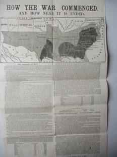
Sold20221864 - How The War Commenced BroadsideHow The War Commenced And How Near It Is Ended. Broadside Published by the National Union Executive Committee Astor House New York - Has Map of The Southern States and Who Commenced The War With A TimSee Sold Price
Sold20221898 Topographical Colored Maps of Worcester County,LJ Richards & Co. Pub. Plate #2 Worcester is missing Cover is detached 22" x 17" Please see photos and come to the 2 day preview for condition.See Sold Price
Sold2021Map of the Southern States - American Civil WarTitle: Map of the Southern States, Including Rail Roads, County Towns, State Capitals, County Roads, the Southern Coast from Delaware to Texas, Showing the Harbors, Inlets, Forts and Position of BlocSee Sold Price
Sold2023Harper & Brothers, Map of the Southern States, Including Rail Roads, County Towns, State Capitals,Title: Map of the Southern States, Including Rail Roads, County Towns, State Capitals, County Roads, the Southern Coast from Delaware to Texas, Showing the Harbors, Inlets, Forts and Position of BlocSee Sold Price
Sold2021Vintage Pull Down Map Hearne Brothers Official ChicagoVintage 1960s Retractible Pull Down Map Hearne Brothers Official Chicago and Southern Cook County . Measures approx 48" x 68" Condition: Map is partially disconnected from the bottom rod. PleSee Sold Price
Sold2015VTG MAPS & SO.PAC TIME TABLES, ETCVARIOUS VINTAGE EPHEMERA - NOVEMBER 1955 ORIGIN OF PLAYA STONE TRACKS, RACETRACK PLAYA, INYO COUNTY, CALIFORNIA - 1980 SOUTHERN PACIFIC WESTERN DIVISION TIMETABLE 16 - 5 SOUTHERN PACIFIC TIME TABLES -See Sold Price
Sold2023MAP, Wales, BlaeuSouthern Wales. Johannes Blaeu, Monumethensis Comitatus. Vernacule Monmouth Shire, 1660 (circa). Black & White. This fine and highly decorative map describes the county in the southeast of Wales, whicSee Sold Price
Jul 06Case Antiques, Inc. Auctions & Appraisals5 TVA Map Books incl. Tennessee & New York c. 1935-1950$250
23 hrs LeftJasper521865 Colton Map of US Southwest -- Colton's Map of California, Nevada, Utah, Colorado, Arizona & New$160
2 days LeftDOYLE Auctioneers & AppraisersOrtelius' historical map of antique "Magna Graecia," present-day Southern Italy$150
Featured23 hrs LeftJasper521659 Blaeu Map of Southern Norway -- Dioecesis Stavangriensis, & Partes Aliquot Vicinae, Opera L.$200
2 days LeftForum AuctionsJefferies (Richard) The Gamekeeper at Home, first edition, original pictorial cloth, gilt, 1878 &£100
3 days LeftRail & Road Auctions45 Peices of Western Railroad Paper Ephemera - Southern Pacific, Northern Pacific, Union Pacific,$30(1 bid)
2 days LeftDOYLE Auctioneers & AppraisersAn eighteenth-century map of Nîmes in Southern France, with views of its Roman monuments$100(1 bid)
3 days LeftRapid Estate Liquidators and Auction GalleryFramed Collection Engravings & A Map From The Excursions In The County Of Sussex Published In 1822$50
2 days LeftEldred'sMAP OF BROOKLINE, MASSACHUSETTS, BELIEVED TO BE THE FIRST PUBLISHED MAP OF THE TOWN, Circa 1844 22"$1,200
Featured2 days LeftJasper52Amér Sep Grandes Antilles 73 Jamaica Pedro Bank San Andrés VANDERMAELEN 1827 map$45