Sold20241831 Woodbridge Maps of Climate, Vegetation and Animals of the World -- Isothermal Chart or View ofTitle: 1831 Woodbridge Maps of Climate, Vegetation and Animals of the World -- Isothermal Chart or View of Climates & Productions… [verso] Chart of the Principal Animals of the World CartographeSee Sold Price
Sold20231831 Woodbridge Maps of Climate, Vegetation and Animals of the World -- Isothermal Chart or View ofTitle: 1831 Woodbridge Maps of Climate, Vegetation and Animals of the World -- Isothermal Chart or View of Climates & Productions… [verso] Chart of the Principal Animals of the World CartographeSee Sold Price
Sold20221823 Woodbridge Maps of Climate, Vegetation and AnimalsTitle: 1823 Woodbridge Maps of Climate, Vegetation and Animals of the World -- Isothermal Chart or View of Climates & Production… Cartographer: W. Woodbridge Year / Place: 1823, Hartford Map DimSee Sold Price
Sold20221831 Woodbridge Map of the United States -- Geographical & Statistical Map of the United States.Title: 1831 Woodbridge Map of the United States -- Geographical & Statistical Map of the United States. Adapted to Woodbridge's Geography Cartographer: W. Woodbridge Year / Place: 1831, Hartford Map DSee Sold Price
Sold20221831 Woodbridge Map of the United States -- Geographical & Statistical Map of the United States.Title: 1831 Woodbridge Map of the United States -- Geographical & Statistical Map of the United States. Adapted to Woodbridge's Geography Cartographer: W. Woodbridge Year / Place: 1831, Hartford Map DSee Sold Price
Sold20231831 Woodbridge Map of North America, Europe, Asia and on verso Map of Pacific Ocean -- PolarTitle: 1831 Woodbridge Map of North America, Europe, Asia and on verso Map of Pacific Ocean -- Polar Projection of North America and Asia [verso] Pacific Ocean with a View of Australia and Polynesia CSee Sold Price
Sold20221831 Woodbridge Map of North America, Europe, Asia andTitle: 1831 Woodbridge Map of North America, Europe, Asia and on verso Map of Pacific Ocean -- Polar Projection of North America and Asia [verso] Pacific Ocean with a View of Australia and Polynesia CSee Sold Price
Sold20221831 Woodbridge Map of South America and Africa -- Comparative, Geographical & Statistical Map ofTitle: 1831 Woodbridge Map of South America and Africa -- Comparative, Geographical & Statistical Map of South America & Africa Cartographer: W. Woodbridge Year/Place1831, Hartford Dimensions: 10.8 XSee Sold Price
Sold20241831 Woodbridge Map of South America and Africa -- Comparative, Geographical & Statistical Map ofTitle: 1831 Woodbridge Map of South America and Africa -- Comparative, Geographical & Statistical Map of South America & Africa Cartographer: W. Woodbridge Year / Place: 1831, Hartford Map Dimension (See Sold Price
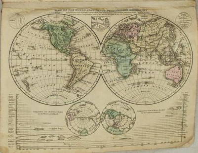
Sold20211831 Woodbridge World Map -- Map of the World AdaptedTitle: 1831 Woodbridge World Map -- Map of the World Adapted to Woodbridge's Geography Cartographer: W. Woodbridge Year / Place: 1831, Hartford Map Dimension (in.): 8.6 X 10.8 in. This is a very niceSee Sold Price
Sold2019Bartholomew, John 1922 Lot of 5 Maps of The WorldIncl Mapping of the World, World-Bathy-Orographical, World Climate, World-Vegetation & Ocean Currents, World-Population. Large Lithograph Maps Published 1922 by The Times, London for "The Times SurveySee Sold Price
Sold20231821 Woodbridge Thematic World Map -- Moral and Political Chart Of The Inhabited World ...Title: 1821 Woodbridge Thematic World Map -- Moral and Political Chart Of The Inhabited World ... Cartographer: W. Woodbridge Year / Place: 1831, Hartford Map Dimension (in.): 8.2 X 10.8 in. This is aSee Sold Price
Sold20211821 Woodbridge Thematic World Map -- Moral andTitle: 1821 Woodbridge Thematic World Map -- Moral and Political Chart Of The Inhabited World ... Cartographer: W. Woodbridge Year / Place: 1831, Hartford Map Dimension (in.): 8.2 X 10.8 in. This is aSee Sold Price
Sold2018William Channing Woodbridge MODERN ATLAS ON A NEW PLANWilliam Channing Woodbridge MODERN ATLAS ON A NEW PLAN TO ACCOMPANY THE SYSTEM OF UNIVERSAL GEOGRAPHY 1831 Hand-Colored Maps Tables Charts Political Physical Zoological Population Commerce United StatSee Sold Price
Sold2018A CHINOISERIE PARCEL GILT ENAMELED EMBOSSED LEATHERA CHINOISERIE PARCEL GILT ENAMELED EMBOSSED LEATHER FOUR PANEL SCREEN, LATE 19TH CENTURY, vegetation, animal and insects comprise a boarder of panels with the theme of the four seasons, centering a fiSee Sold Price
Sold2018A CHINOISERIE PARCEL GILT ENAMELED EMBOSSED LEATHERA CHINOISERIE PARCEL GILT ENAMELED EMBOSSED LEATHER FOUR PANEL SCREEN, LATE 19TH CENTURY, vegetation, animal and insects comprise a boarder of panels with the theme of the four seasons, centering a fiSee Sold Price
Sold20191831 West Point Map by Philip St. George Cockepen and ink topographical map, signed in ink, "Topographical map of West Point - done with pen by Cadet Cocke 1831.", over faint pencil signature "Cocke", on wove paper, image 7-1/4 x 9-1/4 in., overaSee Sold Price
Sold2021Chinese four-leaf screen carved in relief end 19thChinese four-leaf screen carved in relief end 19th century. With decoration of fantastic animals and vegetation. Size: 190 x 204 cms.See Sold Price
Sold2021LARGE INDO PERSIAN HANGING LAMPLARGE INDO PERSIAN HANGING LAMP. Overall ornately pierced with figures, animals and vegetation and with colored glass panels and rooster finial. Height 25 inches (65 cm) excluding original suspensionSee Sold Price
Sold2022Jewish Israeli Brass Hanukkah MenorahsLot of 5 Israeli brass Hanukkah menorahs. Back decorated with figure of menorah, a man, animals, a map of Israel and floral motifs. Height: 12-18.5 cm, width: 15-27 cm.See Sold Price
Sold2017BOXED MIGNOT PREHISTORIC DIORAMAGreat two tier display of land, sea and air dwelling dinosaurs in natural settings including lead trees, rock and mushrooms. 6-14cm. Mushroom and vegetation have some chips, animals overall, (Exc.-PriSee Sold Price
Sold2024Set 8 Italian Ceramic Bird & Rabbit Plates, ItalyLuxury display plate set or dinner set of 8 ceramic hand painted plates, made in Italy., painted green on white background with animals in their vegetation habitat., 10 in. Marked Italy. Rabbit, ChickSee Sold Price
Sold2024John Speed and Francis Lamb "Map of New England and New York", ca. 1676. Hand colored engraved mapJohn Speed and Francis Lamb "Map of New England and New York", ca. 1676. Hand colored engraved map with depictions of animals such as beavers, elk, bears, foxes, and more. Vivid colors. Slight tear upSee Sold Price
Jul 03Oriental Art AuctionsA MAIDEN AND A BEARDED SNAKE CHARMER IN ROCKY LANDSCAPE, QAJAR, PERSIA, 19TH CENTURY€500
Jul 06Case Antiques, Inc. Auctions & AppraisalsHenri Maik O/C Painting, Tiger at Night, 1973$2,400(2 bids)
5 hrs LeftJasper52The Ecstasy of St. Cecilia, after Raphael. Amand-Durand after Marcantonio Raimondi (c.1875)$130
4 days LeftTrillium Antique Prints & Rare BooksBuffon - Pair of Engravings: Celestial or Zodiac Band above the Earth & God with Clouds and Wind$50
8 hrs LeftJasper521693 Conelly Chart of the Earth and Geographic Principles -- Primi Elementi, o Introdutione al Corso$240
4 days LeftTrillium Antique Prints & Rare BooksAudubon - Severn River and Rocky Mountain Flying Squirrel. 143$25
Jul 16BADO e MART AUCTIONSTravels. FERRARIO. Il costume antico e moderno di tutti i popoli. Europa-Asia.€500
3 days LeftLeland LittleHondius and Janssonius's Map of North America, with California as an Island$275(4 bids)
2 days LeftForum AuctionsNatural History.- Godman (F.D.) & Osbert Salvin. Biologia-Central-Americana: Zoology, Botany, an£100
2 days LeftWeatherham Estate TreasuresNative American Indian in Wolf Headdress Bronze Bust Statue Sculpture 14" x 8"$450
181 Lots AwayFreeman's | Hindman[Maps & Atlases] Oliva, Joan: Portolan Chart of the Mediterranean$10,000(1 bid)
Jul 07A-1 Auction17th Century Oil on Panel Painting Signed N. Berchem "Serenade of the Animals"$80(3 bids)
Featured8 hrs LeftJasper521720 Homann Map of the Caspian Sea Region -- Provinciarum Persicarum Kilaniae nempe Chirvaniae$220


![1831 Woodbridge Maps of Climate, Vegetation and Animals of the World -- Isothermal Chart or View of: Title: 1831 Woodbridge Maps of Climate, Vegetation and Animals of the World -- Isothermal Chart or View of Climates & Productions… [verso] Chart of the Principal Animals of the World Cartographe](https://p1.liveauctioneers.com/5584/319185/171438327_1_x.jpg?height=310&quality=70&version=1707858212)


![1831 Woodbridge Maps of Climate, Vegetation and Animals of the World -- Isothermal Chart or View of: Title: 1831 Woodbridge Maps of Climate, Vegetation and Animals of the World -- Isothermal Chart or View of Climates & Productions… [verso] Chart of the Principal Animals of the World Cartographe](https://p1.liveauctioneers.com/5584/285598/150695005_1_x.jpg?height=310&quality=70&version=1681855790)


![1831 Woodbridge Map of North America, Europe, Asia and on verso Map of Pacific Ocean -- Polar: Title: 1831 Woodbridge Map of North America, Europe, Asia and on verso Map of Pacific Ocean -- Polar Projection of North America and Asia [verso] Pacific Ocean with a View of Australia and Polynesia C](https://p1.liveauctioneers.com/5584/285598/150695018_1_x.jpg?height=310&quality=70&version=1681855790)
![1831 Woodbridge Map of North America, Europe, Asia and: Title: 1831 Woodbridge Map of North America, Europe, Asia and on verso Map of Pacific Ocean -- Polar Projection of North America and Asia [verso] Pacific Ocean with a View of Australia and Polynesia C](https://p1.liveauctioneers.com/5584/231769/120064716_1_x.jpg?height=310&quality=70&version=1641336545)


![[Maps & Atlases] Oliva, Joan: Portolan Chart of the Mediterranean (1 of 2)](https://p1.liveauctioneers.com/65/332523/179335172_1_x.jpg?height=282&quality=70&version=1717709445)


