Sold20231821 Woodbridge Thematic World Map -- Moral and Political Chart Of The Inhabited World ...Title: 1821 Woodbridge Thematic World Map -- Moral and Political Chart Of The Inhabited World ... Cartographer: W. Woodbridge Year / Place: 1831, Hartford Map Dimension (in.): 8.2 X 10.8 in. This is aSee Sold Price
Sold20211821 Woodbridge Thematic World Map -- Moral andTitle: 1821 Woodbridge Thematic World Map -- Moral and Political Chart Of The Inhabited World ... Cartographer: W. Woodbridge Year / Place: 1831, Hartford Map Dimension (in.): 8.2 X 10.8 in. This is aSee Sold Price
Sold20211821 Woodbridge Thematic World Map of Type ofTitle: 1821 Woodbridge Thematic World Map of Type of Inhabitation -- Chart of the Inhabited World Exhibiting the Prevailing Religion, form of Government, Degree of Civilization and Population... CartoSee Sold Price
Sold20181843 William Woodbridge World Map1843 William C. Woodbridge Moral and Political Chart of the Inhabited World. Measures 12" x 17.5" (sheet size). G-Vg/Vg condition. Unframed, loose and not mounted or glued down. We ship all items in tSee Sold Price
Sold2019Moral and Political Chart of the Inhabited WorldReserve Reduced! Title/Content of Map: Moral and Political Chart of the Inhabited World Date: c1845 Cartographer: WOODBRIDGE, WILLIAM CHANNING Material/Medium: BELKNAP AND HAMERSLEY Size: 8.25Height -See Sold Price
Sold20221821 Woodbridge Map of the United States -- United StatesTitle: 1821 Woodbridge Map of the United States -- United States Cartographer: W. Woodbridge Year / Place: 1821, Hartford Map Dimension (in.): 8.9 X 11 in. This is a lovely map of the US with inset ofSee Sold Price
Sold20221821 Woodbridge Map of Africa -- AfricaTitle: 1821 Woodbridge Map of Africa -- Africa Cartographer: W. Woodbridge Year / Place: 1821, Hartford Map Dimension (in.): 8.2 X 10.3 in. This is an excellent map of Africa. The center portion of thSee Sold Price
Sold20241821 Woodbridge Map of Asia and Australia -- AsiaTitle: 1821 Woodbridge Map of Asia and Australia -- Asia Cartographer: W. Woodbridge Year / Place: 1821, Hartford Map Dimension (in.): 8.7 X 10.3 in. This is an excellent map of Asia with Australia inSee Sold Price
Sold20241821 Woodbridge Map of South America -- South AmericaTitle: 1821 Woodbridge Map of South America -- South America Cartographer: W. Woodbridge Year / Place: 1821, Hartford Map Dimension (in.): 10.4 X 8.2 in. This is a very nice map of South America. It sSee Sold Price
Sold20211821 Woodbridge Map of North America and Caribbean --Title: 1821 Woodbridge Map of North America and Caribbean -- North America and the West Indies Cartographer: W. Woodbridge Year / Place: 1821, Hartford Map Dimension (in.): 10.8 X 8.6 in. This is a loSee Sold Price
Sold20241822 Woodbridge World Map -- The WorldTitle: 1822 Woodbridge World Map -- The World Cartographer: W. Woodbridge Year / Place: 1822, Hartford Map Dimension (in.): 9.4 X 12.3 in. page This is a very nice double hemisphere world map. It alsoSee Sold Price
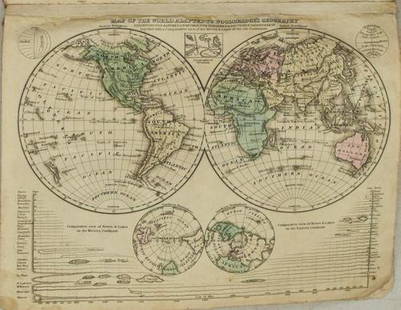
Sold20211831 Woodbridge World Map -- Map of the World AdaptedTitle: 1831 Woodbridge World Map -- Map of the World Adapted to Woodbridge's Geography Cartographer: W. Woodbridge Year / Place: 1831, Hartford Map Dimension (in.): 8.6 X 10.8 in. This is a very niceSee Sold Price
Sold20191821 Chart of the World Map This is a mercator'sThis is a mercator's projection of North America by John Purdy, published Jan 1, 1821 by Richard Holmes Laurie, measures 40" wide by 26.5" tall.See Sold Price
Sold2018Antique Pair Of Maps Of America & The WorldAntique Pair Of Maps Of United States & World, these antique maps are both from W.C. Woodbridge, one map is a world map of the inhabited world, the other is a map of America, the prints have matting bSee Sold Price
Sold2017Woodbridge: Antique Map of North America & West IndiesWOODBRIDGE, W.C. . London: Whittaker, 1821. From "Modern Atlas". Approximately 8-1/2 x 10-1/2, in plastic sleeve. Right margin a little close trimmed (no loss of image), else fine. Depicts the North ASee Sold Price
Sold2021Geographical Map of The WorldGeographical Map of The World with the tracks of the most Celebrated Navigators, for the elucidation of Lavoisne's Geneological, Historical, Chronological, and Geographical Atlas. By C. Gros. 1821 17See Sold Price
Sold2023Sherratt, Russell & Barclay 1821 Antique Map. South Shetland, Antarctic. Rare"Sketch of New South Shetland" Taken in Jan.y & Feb.y 1821. By R. Sherratt. Copper Engraved Map Published C1825., by Fisher & Son, "A Complete Atlas of the World" by John Russell et al. The companionSee Sold Price
Sold20221823 Woodbridge Maps of Climate, Vegetation and AnimalsTitle: 1823 Woodbridge Maps of Climate, Vegetation and Animals of the World -- Isothermal Chart or View of Climates & Production… Cartographer: W. Woodbridge Year / Place: 1823, Hartford Map DimSee Sold Price
Sold20241831 Woodbridge Maps of Climate, Vegetation and Animals of the World -- Isothermal Chart or View ofTitle: 1831 Woodbridge Maps of Climate, Vegetation and Animals of the World -- Isothermal Chart or View of Climates & Productions… [verso] Chart of the Principal Animals of the World CartographeSee Sold Price
Sold20231831 Woodbridge Maps of Climate, Vegetation and Animals of the World -- Isothermal Chart or View ofTitle: 1831 Woodbridge Maps of Climate, Vegetation and Animals of the World -- Isothermal Chart or View of Climates & Productions… [verso] Chart of the Principal Animals of the World CartographeSee Sold Price
Sold20221821 Chart of the World/Division of the EarthTwo maps within a single frame. (1) Chart of the World as Known to the Ancients on Mercator’s Scale, and (2) Divisions of the Earth among the Posterity of Noah. Great original full hand coloringSee Sold Price
Sold2016T-O World Map.- Lucanus (Marcus Annaeus) Pharsalia,Lucanus (Marcus Annaeus) Pharsalia, manuscript on paper, [Northern Italy (possibly Padua), first half of the fifteenth century]. 294 x 217mm., I + 149 + I leaves (including defective leaves and 3 blanSee Sold Price
Sold2024Petrus Plancius, Engraved World MapOrbis Terrarum Typus de Integro Multis in Locis Emendatus. Petrus Plancius (1552-1622). Copper-plate engraving with original hand color in full. Amsterdam, 1594. Some stains, creases, folds. Sight sizSee Sold Price
2022Blaeu, Johannes (Netherlands, 1596-1673) "The New World Map" Double Hemisphere World Map C. 1664Nova et Accuratissima Totius Terrarum Orbis Tabula Translated "The New World Map", Hand Colored w/ Elaborately Decorated Spandrels.   Sight View 16" x 21-1/2", Overall View 21" x 25-1/2"See Sold Price
4 days LeftJasper521753 Prevost Map of Pacific Wind Currents -- Representation du Cours ordinaire des Vents de Traverse$85
5 hrs LeftRapid Estate Liquidators and Auction GalleryVintage Cricket Gillette World Map Lighter Holder$10
May 14Akiba Galleries(2 Pc) Allain Manesson Mallet Description De L'Univers 2 Vol. German Translation$200(1 bid)
1 day LeftTrillium Antique Prints & Rare BooksPtolemy & Magini, pub. 1620 - Map of the World$50(1 bid)
May 17Royal Treasures Warehouse LLC1530s Old Map of the World as seen from the North & South Poles$100


![1831 Woodbridge Maps of Climate, Vegetation and Animals of the World -- Isothermal Chart or View of: Title: 1831 Woodbridge Maps of Climate, Vegetation and Animals of the World -- Isothermal Chart or View of Climates & Productions… [verso] Chart of the Principal Animals of the World Cartographe](https://p1.liveauctioneers.com/5584/319185/171438327_1_x.jpg?height=310&quality=70&version=1707858212)
![1831 Woodbridge Maps of Climate, Vegetation and Animals of the World -- Isothermal Chart or View of: Title: 1831 Woodbridge Maps of Climate, Vegetation and Animals of the World -- Isothermal Chart or View of Climates & Productions… [verso] Chart of the Principal Animals of the World Cartographe](https://p1.liveauctioneers.com/5584/285598/150695005_1_x.jpg?height=310&quality=70&version=1681855790)

![T-O World Map.- Lucanus (Marcus Annaeus) Pharsalia,: Lucanus (Marcus Annaeus) Pharsalia, manuscript on paper, [Northern Italy (possibly Padua), first half of the fifteenth century]. 294 x 217mm., I + 149 + I leaves (including defective leaves and 3 blan](https://p1.liveauctioneers.com/5458/94966/48431616_1_x.jpg?height=310&quality=70&version=1476369049)


