Sold20192 Ursula Fookes Linocuts, Built Up Town & PastoralTwo (2) Ursula Mary Fookes (British, 1906-1991) linocuts. 1st item: "Pastoral Scene," depicting a walled city rising above a landscape, signed "UMFookes" lower left and numbered 4/50. Sight: 9 3/8" HSee Sold Price
Sold2020Laurie & Whittle Map of AmericaLAURIE & WHITTLE (Late 18th Century)The United States of America...Engraved map with original hand color in full.London: Laurie & Whittle, 1794.20 1/4" x 22 1/2" sheet.The first British map to show thSee Sold Price
Sold2022D'Oyly-John (British, 1906-1993) The harbour at Cannes, a pair both 42.8 x 58.1cm (16 7/8 x 22 7...D'Oyly-John (British, 1906-1993) The harbour at Cannes, a pair each signed 'DOYLY-JOHN' (lower left) oil on canvas both 42.8 x 58.1cm (16 7/8 x 22 7/8in). (2) This lot is subject to the following lotSee Sold Price
Sold2016JOHN SPEED (BRITISH, 1552-1629) MAP OF THE WORLDJOHN SPEED (BRITISH, 1552-1629) MAP OF THE WORLD, (UPDATED 6/14/16) hand-colored engraving on laid paper, titled "A New and Accurat Map of the World Drawne according to ye truest Descriptions latest DSee Sold Price
Sold2023Forster Robson ''A Midsummer's Night Dream'' 1893 WatercolorForster Robson (fl.1888-1906 British) ''A Midsummer's Night Dream'' 1893 Watercolor and Gouache on Board 30''x40'' Image. Museum quality pre-raphaelite composition with nymph. Signed and dated l.r. OrSee Sold Price
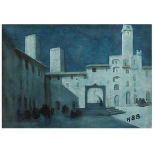
Sold2022Hercules Brabazon Brabazon (British, 1821-1906), Moroccan NocturneHercules Brabazon Brabazon (British, 1821-1906), Moroccan Nocturnewatercolor, monogrammed "HBB" at lower right, may be another North African location, matted and framed. Frame dimensions 19 1/2 x 23 1See Sold Price
Sold2019STRAITS SETTLEMENT British Administration $1 1906 A/2British Administration $1 1906 A/2 11518 (KNB1) Rare. Original VF.See Sold Price
Sold2018Bleau Map of AsiaBLAEU, Willem Janszoon (1571-1638). Asia Noviter Delineata…Engraved map with original hand color. Amsterdam, c. 1618-1650. 20 x 24 inches sheet, 25 1/8 x 21 3/8 inches framed This is one of the mostSee Sold Price
Sold2016Sylvester Martin (British, Active 1856-1906)Sylvester Martin (British, Active 1856-1906), "The Meet at Beoley, Warwickshire", "Off to the Meet", and "Breaking Cover", three oils on canvas, each signed, former further inscribed en verso, each 18See Sold Price
Sold2017Mercator (Gerard) - Atlas sive Cosmographicae,Editio Quinta, engraved pictorial title, prelims, 49 double-page maps, including Asia, Russia, Turkey, Lithuania, Asia Minor and Persia, regions of Italy Spain, Germany and Eastern Europe, and 11 singSee Sold Price
Sold2015ERNEST CASTELEIN C. 1906ERNEST CASTELEIN, (BRITISH, 1881-1945), C. 1906, H 40", W 30":Signed and dated lower left. In a carved gilt wood frame. For a high resolution photo CLICK HERESee Sold Price
Sold2022(BRITISH EMPIRE.) George Philip & Son, Ltd.; and The London Geographical Institute. Navy League Map(BRITISH EMPIRE.) George Philip & Son, Ltd.; and The London Geographical Institute. Navy League Map of the British Empire. Oversize chromolithograph map of the world delineating early 20th-century BriSee Sold Price
Sold2023TWO ANTIQUE MAPS OF CHINA.Two antique maps of China, including Chinae by Abraham Ortelius, 1595, image 14.25” x 18.25”, with map of Eastern Asia, Le table de la region orientale, image 10” x 13.5”.See Sold Price
Sold2015De Bry (Theodore) - Descriptio Hydrographicathe 2-sheet map of Africa and Asia, from the east coast of Brazil to Japan, charting the first Dutch voyage to the East Indies by Houtman, large titlecartouche upper centre of right sheet, ships, compSee Sold Price
Sold2017William Faden, rare Revolutionary War Map of NYWilliam Faden, rare Revolutionary War Map of NY, William Faden (British, 1749-1836), "A Plan of the Operations of the Kings Army under the Command of General Sr. William Howe, K.B. in New York and EasSee Sold Price
Sold2024John Bowles (British 1709 - 1779)John Bowles (British 1709 - 1779) "A New and Exact Map of America Laid Down from the Latest Observations and Discoveries", circa 1750 Two sheet map engraving of the "Representation of the Customs andSee Sold Price
Sold20151845 MITCHELL'S REFERENCE & DISTANCE WALL MAP U.S.SHOWING MITCHELL'S 1845 REFERENCE AND DISTANCE WALL MAP OF THE UNITED STATES WITH GENERAL MAP OF THE US WITH CONTIGUOUS BRITISH AND MEXICAN POSSESSIONS.PHILADELPHIA : S. AUGUSTUS MITCHELL COPPER-ENGRASee Sold Price
Sold2022Middle East.- Saudi Arabia.- Saudi Aramco (publisher) Collection of maps and ephemera from compiledMiddle East.- Saudi Arabia.- Saudi Aramco (publisher) and others. Collection of maps and ephemera compiled by a British Engineer working in the Middle East, including 5 laminated maps of Saudi Arabia,See Sold Price
Sold2016Malaya & British Borneo, 1961, 10 Dollar. consecutiveMalaya & British Borneo, 1961, 10 Dollar. A/65 528761-770, consecutive nos. 10pcs, Signature by Tun Tau Siew Sin, Financial Chairman. Engraved & Printed by Thomas De La Rue & Co. Ltd., England. All PMSee Sold Price
Sold2016Malaya & British Borneo, 1961, $10, Big €œA€ serial,Malaya & British Borneo, 1961, $10, Big €œA€ serial, A/83 084473/72, printing error, two different serial numbers on same note, Printer: Thomas De La Rue & Co., Ltd. PMG AU 58 EPQ 马来See Sold Price
Sold2016Malaya, WWII, British Army PropagandaMalaya, WWII, British Army Propaganda, 1944-45, $10, Block MN, “Wang Jepun Akan Mati Bersama 2 Jepan”, Tan J19, KNB16. PMG AU 55 EPQ 马来亚, 二战, 英国See Sold Price
Sold2021George III Figured Mahogany Eight Drawer Map CaseBritish, 18th century, in old surface with rich brown color, highly figured top over eight dovetailed drawers with oak linings, probably original gilt brass pulls, brass carrying handles, set on straiSee Sold Price
Sold2022BRITISH ISLES LILY (GEORGE) Britanniae insulae quae nunc Angliae et Scotiae regna continet cum H...BRITISH ISLES LILY (GEORGE) Britanniae insulae quae nunc Angliae et Scotiae regna continet cum Hibernia adiacente nova descriptio, double-page engraved map, land masses hand-coloured, title cartoucheSee Sold Price
Sold2017Engraved Map, Renold ElstrackeRenold Elstracke (British, 1590-1630), "The North part of America," 1625, copper engraved map with had coloring, image: 11.25"h x 14."w, overall (with frame): 18.25"h x 22.25"w Likely a 20th century rSee Sold Price
6 days LeftJasper52St Christophers, Nevis & St Lucia. St Kitts. West Indies. THOMSON 1830 old map$120
6 days LeftJasper52Kingston approach Jamaica south coast Caribbean ADMIRALTY chart 1962 (1966) map$120
6 days LeftJasper52Venezuela Coast Trinidad Tobago Isla Margarita ADMIRALTY chart 1894 (1950) map$120
4 days LeftFreeman's | Hindman[Maps & Atlases] A New Map of North America, with the West India Islands...$300
Featured6 days LeftJasper52British West Indies. Virgin Leeward Windward Islands. Bermuda. SWANSTON 1860 map$120
6 days LeftForum AuctionsCodrington (Robert) His Majesties Propriety, and Dominion on the British Seas asserted, first£100
Jun 30GOLDEN SUN AUCTIONS, Inc. (formerly Appraisal & Estate Sale Specialists, Inc.)Antique Sterling Vesta Cases & Sovereign Holders-UK & USA$40(1 bid)
6 days LeftEverard Auctions & AppraisalsLord Randolph Churchill by Winston Churchill, Signed$125(1 bid)


![[Maps & Atlases] A New Map of North America, with the West India Islands... (1 of 2)](https://p1.liveauctioneers.com/65/332523/179335173_1_x.jpg?height=282&quality=70&version=1717709447)


![[EAST] LOT OF 3 VOLUMES SOLD TOGETHER (1 of 5)](https://p1.liveauctioneers.com/8124/333020/179782281_1_x.jpg?height=282&quality=70&version=1718304262)
