Sold2021Carolina’s with parts of Georgia and Virginia, earlyTitle: Carolina’s with parts of Georgia and Virginia, early map of southern United States, by Bonne/ Raynal 1780 Date/Period: 1780 Materials: Copperplate engraved Size: 13 1/2 x 9 3/4'' Shows aSee Sold Price
Sold2017Early Map of Georgia, John Payne, Circa 1810John Payne (American, 18th/19th century), "Georgia from the latest Authorities 1810"-1810/11. An early American engraved map of the Southern United States by mapmaker John Payne (American, 18th/19th cSee Sold Price
Sold20231844 ATLAS Geography 19 MAPS Early America United States Southern School1844 ATLAS Geography 19 MAPS Early America United States Southern School Jesse Olney was a 19th-century American historian who published a number geographical and history readers including his famousSee Sold Price
Sold2023MAP, Southern USA, BellinColonial Southern United States. Jacques Nicolas Bellin, Partie de la Coste de la Louisiane et de la Floride Depuis le Mississipi Jusqua St. Marc d'Apalache Dressee sur les Manuscrits du Depost des PlSee Sold Price
Sold20201852 OLD ANTIQUE MAP SOUTHERN UNITED STATES, MITCHELL1852 OLD ANTIQUE MAP SOUTHERN UNITED STATES, MITCHELL FL GA SC NC TN MS AR LA AL 1852 Antique Map by S. Augustus Mitchell of Pennsylvania. ??No. 12 - MAP OF THE CHIEF PART OF THE SOUTHERN STATES AND PSee Sold Price
Sold2017Moll: Antique Map of West Indies Central America, 1746Title/Content of Map: Southern United States, West Indes Mexico Central America Date Printed: 1746 Cartographer: Thomas Salmon & Herman Moll Material/Medium: Paper Size: 14 1/2" 9 1/2" Copperplate engSee Sold Price
Sold2018Mitchell: Antique Map of Southern United States, 1852Title/Content of Map: 1852 Mitchell Map of Southern United States -- No. 12 Map of the Chief Part of the Southern States and Part of the Western... Date Printed: 1852 Philadelphia Cartographer: S MitcSee Sold Price
Sold20201858 Mitchell Map of Southern United States -- No. 12Title/Content of Map: 1858 Mitchell Map of Southern United States -- No. 12 Map of the Chief Part of the Southern States and Part of the Western... Date: 1858, Philadelphia Cartographer: S Mitchell SiSee Sold Price
Sold2017Pinkerton: Map of the Southern United States, 1809Map: 1809 Pinkerton Map of the Southern United States Maker: J. Pinkerton Published: 1809 London Size: 20 x 27.5 in. plus matting. A different and unique perspective of the Southern US showing VirginiSee Sold Price
Sold2021Early map of the Southern States (pre-Atlanta), 1844Title: Early map of the Southern States (pre-Atlanta), 1844 Description: Great steel engraved map showing the South seventeen years before civil war broke out. Atlanta is not shown as it won’t be foSee Sold Price
Sold2021TWO EARLY 19TH C. SOUTHERN UNITED STATES POTTERY JUGSThe larger having tooled mouth with incised line, tooled base, strap handle, nice color, no markings. Plus another with pronounced tooled mouth and nice brown color, no markings. Measure 10 and 11 incSee Sold Price
Sold2024Rare Hand-coloured Map - Florida - Louisiana - United States - BellinIts finely engraved, hand-coloring engraved map from the Dutch edition of acques Nicolas Bellin "Histoire General of Travel". Published in Amsterdam, 1770 year. Carte de la Floride de la LouSee Sold Price
Sold2017Map of United States, Texas & Oklahoma as 1 TerritoryEarly map of the United States with Texas and Oklahoma as one territory. W. R. Chambers. Circa 1850 map of the United States extends into the Great Plains here split up between Nebraska and Kanzas TerSee Sold Price
Sold2015Early MapEarly map of The United States. Marked "New Indexed Pictorial Map of the United States and World....Published By J. R. Spaulding & Co....". Map 43" x 61".See Sold Price
Sold2022Early Hand Drawn Map of United States in 1817,by Mary Young, image area 20" X 30" plus frame.See Sold Price
Sold2022HEPPLEWHITE SLANT-LID DESK Southern United States, Early 19th Century Height 53”. WidthHEPPLEWHITE SLANT-LID DESKSouthern United States, Early 19th CenturyIn mahogany, with poplar and pine secondary woods.Height 53”. Width 41”. Depth 22”.See Sold Price
Sold2020Early Map of America, Eastern United States, M. SeutterTitled "Novi Belgii in America Septentrionali" with very elaborate cartouche and with vignette view of New Amsterdam (New York). Exquisite color, well preserved, laid down. Size: 19 7/8" x 22 3/4" (siSee Sold Price
Sold2022Scarce early Cram RR map of Southern states“New Railroad and County Map of Alabama, Georgia, South Carolina and North Carolina” from the extremely scarce 1882 edition of Cram’s Unrivaled Family Atlas of the World. This was tSee Sold Price
Sold2018Southern provinces of the United States. THOMSON. WestTITLE/CONTENT OF MAP: 'Southern provinces of the United States' The map shows the United States including the first 17 states to acceed, including Tennessee, which had joined in 1796. Ohio, LouisianaSee Sold Price
Sold2023Southern provinces of the United States. THOMSON. West & East Florida 1830 mapTITLE/CONTENT OF MAP: 'Southern provinces of the United States' The map shows the United States including the first 17 states to acceed, including "Tenasee" (Tennessee), which had joined in 1796. OhioSee Sold Price
Sold2023Southern provinces of the United States. THOMSON. West & East Florida 1817 mapTITLE/CONTENT OF MAP: 'Southern provinces of the United States' The map shows the United States including the first 17 states to acceed, including Tennessee, which had joined in 1796. Ohio, LouisianaSee Sold Price
Sold20201873 Geological Map of the United States Compiled byThis colorful map of the United States was compiled by Professors C.H. Hitchcock and W.P. Blake and is one of the most important early geological maps of the United States, one which would be copied bSee Sold Price
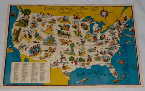
Sold2022Walt Disney Dixon's Mickey Mouse Map of United StatesEarly Disneyana collectible map. Copyright Walt Disney Enterprises 1935. Rare early pictorial map of the United States , richly illustrated with Disney character vignettes in each of the 48 states, MiSee Sold Price
Sold2018Thomson: Antique Map of Southeastern United States 1817Southern Provinces of the United States A beautiful exemplar of the southern United States map from Thomson's New General Atlas, with a lovely inset view of "Characteristic Scenery of the Hudson RiverSee Sold Price
1 day LeftTrillium Antique Prints & Rare BooksBonne - Map of the Eastern Coast of North America$85(3 bids)


![[Maps] American Atlas, Folio (1 of 14)](https://p1.liveauctioneers.com/3532/326332/175680379_1_x.jpg?height=282&quality=70&version=1713151485)


