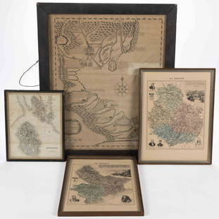
Sold2023ASSORTED EUROPEAN AND ASIAN MAPS, LOT OF FOURASSORTED EUROPEAN AND ASIAN MAPS, LOT OF FOUR, engraving on paper, three with hand-coloring, comprising a map of Buteshire in Scotland by William Home Lizars (Scottish, 1788-1859), two "LA FRANCESee Sold Price
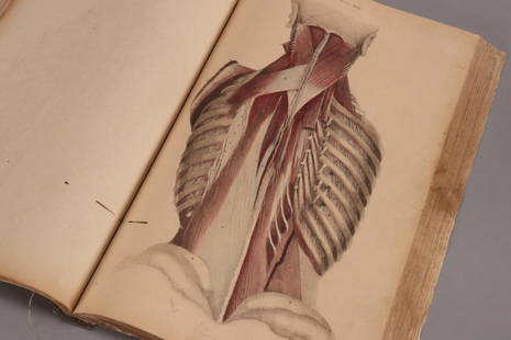
Sold202319th Century Atlas of Anatomia Engraved byWilliam Home Lizars (1788-1859), talented Edinburgh engraver and publisher for Daniel Lizars, for John Lizars Scottish surgeon, anatomist and medical author, comprised of hand coloured engravings on tSee Sold Price
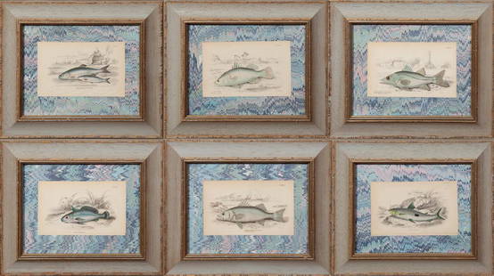
Sold2019William Home Lizars (1788-1859), Group of SixWilliam Home Lizars (1788-1859), Group of Six Hand-Colored Fish Prints from "The Natural History of Fishes" by William Jardine, consisting of "Anotus Notatus," "Labrax Lupus," "Corvina grunniens," "CeSee Sold Price
Sold2022JOHN JAME AUDUBON ICELAND OR JER FALCON HAVELLJohn James Audubon (1785-1851) Iceland or Jer Falcon (Plate CCCLXVI) Gyrfalcon, Falco rusticolus. Antique engraving with etching, aquatint and hand-coloring. By William Home Lizars (1788-1859) and RobSee Sold Price
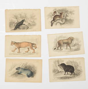
Sold2015William Home Lizars (1788-1859), Group of Ten HandWilliam Home Lizars (1788-1859), Group of Ten Hand Colored Prints of Animals, unframed, consisting of "The Rein Deer," "The Agazel," "The Wapiti," "The Addax," "The Muntjak," "The Elk or Moose," "TheSee Sold Price
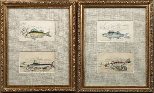
Sold2016William Home Lizars (1788-1859), "Acerina Vulgaris,"William Home Lizars (1788-1859), "Acerina Vulgaris," and "Common Sword-Fish," and "Lucioperca Sandra," and "Oriental Dactylopterus," 1840, four hand-colored fish prints, presented in two gilt frames wSee Sold Price
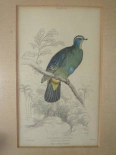
Sold2023Ptilinopus Monachus - Edward LearPtilinopus Monachus - Blue Capped Turteline Edward Lear - William Home Lizars (1788 - 1859) Engraver Artist: Edward Lear Print Type: Engraving Hand Colored<See Sold Price
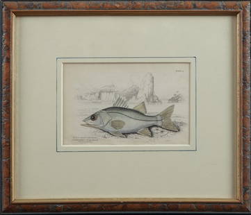
Sold2016William Home Lizars (1788-1859), "CentropomusWilliam Home Lizars (1788-1859), "Centropomus Undecimalis," 19th c., hand-colored fish print, presented in a wood frame with a gilt liner, H.- 4 in., W.- 6 1/4 in.See Sold Price
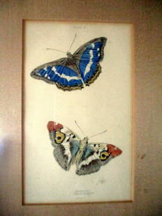
Sold2021Purple Emperior - Lizars ButterfliesPurple Emperior Artist: William Home Lizars (1788 - 1859) Print Type: Engraving Hand Colored Date: Circa 1830's Origin: EdinburghSee Sold Price
Sold2021Small Tortoise Shell - Lizars ButterfliesSmall Tortoise Shell - Painted Lady Artist: William Home Lizars (1788 - 1859) Print Type: Engraving Hand Colored Date: Circa 1830's Origin:See Sold Price
Sold2016William Homes Lizars (1788-1859), "TrochilusWilliam Homes Lizars (1788-1859), "Trochilus Gramineus," "Trochilus Petasphorus," "Trochilus Scutatus," and "Trochilus Quadricolor," 19th c., four hand-colored hummingbird prints, presented in gilt anSee Sold Price
Sold2019William Lizars, (6) hand-colored engravingsWilliam Lizars, (6) hand-colored engravings, William Home Lizars (Scottish, 1788-1859), hand-colored engravings on paper, signed in the plate lower right, loose and unframed, 4.25"h x 6.5"w (sheet)See Sold Price
Sold2022William Home Lizers: The Naturalist's LibraryOver 30 hand-colored engravings from "The Naturalist's Library", by William Home Lizers (Scottish 1788-1859). Published 1833-1845 by Sir William Jardine and engraved by W.H. Lizars, “The NaturalSee Sold Price
Sold2022WILLIAM H. LIZARS. MAP OF POLAND & LITHUANIA 1828Lizars, William Home. POLAND AND LITHUANIA (Edinburgh, ca. 1828). Engraved map showing territories of the formerPolish-Lithuanian Commonwealth, including Belarus and Latvia, large parts of Ukraine andSee Sold Price
Sold2016William Lizars (1788-1859), "The Spined Serragamus,"William Lizars (1788-1859), "The Spined Serragamus," and "Mesoprion Chrysurus," 19th c., pair of hand colored fish prints, framed, Serranus- H.- 3 3/4 in., W.- 6 in.See Sold Price
Sold2023South America /Atlantic Ocean. Gran Colombia. United Provinces. LIZARS 1842 mapTitle: South America /Atlantic Ocean. Gran Colombia. United Provinces. LIZARS 1842 map Description: South America' by William Home Lizars (1842). Antique 19th century atlas map with original hand coloSee Sold Price
Sold2023United States of North America, Pacific States by Joseph Wilson Lowry 1859 mapDescriptionCAPTION PRINTED BELOW PICTURE: The United States of North America, Pacific States [including California, Oregon, Washington, Utah, and part of New Mexico, ]The map shows Washington, Oregon,See Sold Price
Sold2023TWO ANTIQUE AFRICAN MAPS.Early hand colored engraved map of North Africa by Edward Wells, ca. 1700, “A New Map of the North Part of Antient Africa..” image 14.25” x 19”, overall 22” x 27”.See Sold Price
Sold2024A framed 1844 Mitchell map of New EnglandA hand colored copy of S. Augustus Mitchell's Map of the New England or Eastern States, published in 1844, showing also parts of New York, New Brunswick and "Canada East", as Lower Canada was known frSee Sold Price
Sold2015A New Map of the East IndiesTaken from M. de Fer's Map of Asia by Edward Wells (1667-1727), circa 1700, hand-colored map was part of a set of 22 maps dedicated to William, Duke of Gloucester, title cartouche includes the Royal CSee Sold Price
Sold2019R. Wells, "A new map of the North Part of AntientR. Wells, "A new map of the North Part of Antient Africa showing and Egypt, Dedicated to William Duke of Glouchester," 1712,engraved by R. Spofforth, H. - 17 3/8 in., W. - 21 in.See Sold Price
Sold20211859 Italy MapAuthor: Chambers Title: 1859 Italy Map Medium: Ink on Paper Dimensions: 9.5"X11.5" Map of Italy dated 1859. Part of the Modern & Ancient Geography Atlas. Engraved by J.Gellatly. Published by William aSee Sold Price
Sold2019Framed Map of Yorkshire, EnglandEast Riding Division, home of Thomas Tenney before migrating to New England. Map makers: Christopher Saxton, Surveyor and Cartographer; William Kip, Engraver and Printer. [Map: 7 x 9 inches; Frame: 14See Sold Price
Sold2023WILSON, Charles William, Sir. Picturesque Palestine, Sinai and Egypt. FIRST EDITION, IN THEWILSON, Charles William, Sir (1836-1905). Picturesque Palestine, Sinai and Egypt. New York: D. Appleton and Company, 1880-1883. 40 volumes in 40 original parts, 4to. 2 maps, 40 steel engravings, and 5See Sold Price
2 hrs LeftJasper52Nouvelle Caledonie. Baies de Kuakue et de Uinne'. CHAMBEYRON sea chart 1891 map$100
May 09Hunt and Peck Estate Services, Inc.Jacques Nicolas Bellin Map Of Western Part Of New France Or Canada$200(1 bid)
May 11Crescent City Auction GalleryWilliam H. Williams (1817-1886), New Orleans "Map of the Sixth District and Carrollton," 1871, H.-$650
May 12Schilb Antiquarian Rare Books1859 AFRICA VOYAGES Barth Timbuktu Tripoli SLAVES Illustrated Slavery MAP African$62(4 bids)
6 days LeftFreeman's | HindmanUNITED NATIONS | A Home to the World. WITH A TYPED LETTER FROM THE UN DEVELOPMENT CORPORATION.$50
May 18Fontaine's Auction GalleryAttr. Pottier & Stymus (1859-1910), Gilt-Incised, Ebonized & Gilt Bronze-Mounted Rosewood Credenza$2,200
May 09Hunt and Peck Estate Services, Inc.1788 Henry Boswell "Historical Descriptions of New and Elegant Picturesque Views of the Antiquities$50(1 bid)
May 14Akiba Galleries(2 Pc) Allain Manesson Mallet Description De L'Univers 2 Vol. German Translation$200(1 bid)
May 10Rail & Road AuctionsEleven Army Corps of Engineers Port Series No. 1 Through No. 8 Books with Fold Out Maps$35(2 bids)
May 09Hunt and Peck Estate Services, Inc.1776 William Burke 1st Ed 2 Volumes "An Account of the European Settlements in America"$100
4 days LeftTremont AuctionsJohn Speed and Francis Lamb "Map of New England and New York", ca. 1676. Hand colored engraved map$900(3 bids)


![United States of North America, Pacific States by Joseph Wilson Lowry 1859 map: DescriptionCAPTION PRINTED BELOW PICTURE: The United States of North America, Pacific States [including California, Oregon, Washington, Utah, and part of New Mexico, ]The map shows Washington, Oregon,](https://p1.liveauctioneers.com/5584/311630/167410815_1_x.jpg?height=310&quality=70&version=1701439692)


![[JOHN BROWN] Mayor of Harpers Ferry Signed Document (1 of 2)](https://p1.liveauctioneers.com/7226/322253/173251666_1_x.jpg?height=282&quality=70&version=1710004847)
