Sold2022Corea and Japan by John Thomson. East Asia. Korea 1830 old antique map chartTITLE/CONTENT OF MAP: 'Corea and Japan' DATE PRINTED: 1830 IMAGE SIZE: Approx 52.0 x 66.5cm, 20.5 x 26.25 inches (Large); Please note that this is a folding map. TYPE: Antique early 19th century atlasSee Sold Price
Sold2018Antique 19th Century Map of Europe9.5x12 inches; McNally's system of geography, map number 21; drawn by J. Wells, N.Y.See Sold Price
Sold2021Group of 4 Maps, incl. North America & MexicoFour (4) 19th Century Maps of North America and Mexico. 1st item: NORTH AMERICA map, drawn and engraved by John C. Russell, Jr., from GEOGRAPHY, ON A POPULAR PLAN, FOR THE USE OF SCHOOLS AND YOUNG PERSee Sold Price
Sold2023Antique Map Print - Map of World - Scheme of Oceanic and Continental BasinsDescription: This vibrant hand-colored map of the world was published in Chicago by Rand McNally in the last quarter of the 19th century for inclusion in the company’s geography textbook, McNallSee Sold Price
Sold2023GEOGRAPHY MAP PUZZLES. 19TH CENTURY. 2 ITEMSMcLoughlin Bros (New York). DISSECTED MAP OF THE UNITED STATES * A NEW DISSECTED MAP OF THE UNITED STATES. N.d.; 1887. Colour-illustrated boxes. *Additional images and detailed condition reports are aSee Sold Price
Sold2022Antique Miniature Map Dresser 19th CenturyAntique Miniature Map Dresser 19th Century. Measure 11" X 18" X 15.5". This, and many lots forthcoming were found at the massive central Florida estate of a true antiquarian who amassed his magnificenSee Sold Price
Sold2019ANTIQUE MAPS OF THE 19TH CENTURYANTIQUE MAPS OF THE 19TH CENTURY Height: 10 in. by Width: 8 in. by Depth: 1See Sold Price
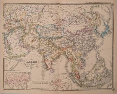
Sold2017Perthes: Antique Map of Asia in 15th Century, 1855Map: 1855 Perthes Map of Asia in 15th Century -- Asien gegen die Mitte des Funften Jahrhunderts... Date Printed: 1855, Gotha Cartographer: J Perthes Size: 12.9 x 16.5 in. Condition: Very good-excellenSee Sold Price
Sold2017Perthes: Antique Map of Asia in 13-14th Centuries, 1855Map: 1855 Perthes Map of Asia in the 13th and 14th Centuries -- Asien im XIII-ten & XIV-ten Jahrhundert… Date/Place: 1855, Gotha Cartographer: J Perthes Size: 12.7 x 16 in. Condition: Very good-exceSee Sold Price
Sold2018Map of the United States Solomon Schoyer 1826 EngravingWonderful Early 19th Century Antique Map of the United States - By Solomon Schoyer. Map of the United States Drawn from the Most Approved Surveys. New York: Solomon Schoyer, 1826. An Engraved foldingSee Sold Price
Sold2016Antique Map, Eastern Passages to China, Horsburgh19th century antique map: Eastern Passages To China Sheet 1 (Java, Bali, Lombock, Sumbawa, Southern Borneo, Celebes, etc.). Includes Sketch of the Bally Strait. Map maker James Horsburgh, London 1848.See Sold Price
Sold2023Antique 19th C. Map of East Los Angeles CountyAntique 19th Century panoramic map of East Los Angeles County, California, depicting a bird's-eye view from Los Angeles River looking towards the Sierra Madre Mountains. Printed by H.S. Crocker & Co.,See Sold Price
Sold2024An Antique Dha Sword & Scabbard, Southeast Asia, C. 19th Century - An antique Dha sword, Burmese,An Antique Dha Sword & Scabbard, Southeast Asia, C. 19th Century - An antique Dha sword, Burmese, Cambodian or Vietnamese. Single edge blade with light engraving of florals near the hilt. The hilt hanSee Sold Price
Sold2023Highly collectible 1860 RR map of Texas, S. A. Mitchell, Jr.One of the most attractive atlas maps of Texas to appear in the mid-19th century. This authentic antique map (160 years old) was published when the Civil War was at its height. It shows the region froSee Sold Price
Sold2023America. North/South Americas. California Missions. THOMSON 1830 old mapTITLE/CONTENT OF MAP: 'America' DATE PRINTED: 1830 IMAGE SIZE: Approx 53.0 x 64.0cm, 20.75 x 25.25 inches (Large); Please note that this is a folding map. TYPE: Antique early 19th century atlas map wiSee Sold Price
Sold2023Early 19th century "Europe" by John Thomson 1817 old antique map plan chartTITLE/CONTENT OF MAP: 'Europe' DATE PRINTED: Published in 1817 IMAGE SIZE: Approx 49.0 x 56.5cm, 19.25 x 22.25 inches (Large); Please note that this is a folding map. TYPE: Antique early 19th centurySee Sold Price
Sold2017Antique Pair Miniature Bronze Foo DogsAntique Pair Miniature Bronze Foo Dogs. Asia. 19th Century. Bronze1 7/8 Inches high, 1 5/8 Inches long, each. This early 19th century pair of highly detailed, miniature bronze Foo Dogs mirror each othSee Sold Price
Sold20171833 Nubia & Abyssinia EGYPT Ethiopia Africa Missions1833 Nubia & Abyssinia EGYPT Ethiopia Africa Missions Geography MAP Bishop Michael Russell was a 19th-century historian who was well-versed in a variety of subjects, including Biblical and Holy Land hSee Sold Price
Sold2023Antique 19th century Sampler map of England Hariot CrugerHas a great look and hard to believe was Created by a 7 year old.Probably dates to middle 19th century or slightly later. Has damage as shown. Measures 16 x 20" with frame. Shipping includes insuranceSee Sold Price
Sold2023Antique map of Juan de la Cosa, late 19th Century facsimileLate 19th Century facsimile of the map of Juan de la Cosa is a world map that includes the earliest known representation of the New World and the first depiction of the equator and the Tropic of CanceSee Sold Price
Sold2020Monteith Geography 19th Century Color MapsComprehensive Geography Local, Physical, Descriptive, Historical, Mathematical, Comparative, Topical, Commercial and Ancient with Map-Drawing and Relief Maps. Edition for NewSee Sold Price
Sold2019Derbyshire 19th Century Lot of 7 Antique Maps, ChartLot of six 19th Century Maps and one 18th Century Chart. All Derbyshire. Examples by Lewis, Dugdale, Phillips/Cooper, Weller/Weekly Dispatch and others. Paper Size: Up to 18.5 x 13.5 inch (47 x 34cm)See Sold Price
Sold202217C. Jodocus Hondius Map of Asia Colored EngravingAntique 17th century map of Asia by Jodocus Hondius (Belgian Dutch, 1563-1612). Colored engraving originally published in 1631. Displayed in a wooden frame. Work Size: 15 x 19.5 in.SHIPPINGHill AuctioSee Sold Price
Sold2023South America /Atlantic Ocean. Gran Colombia. United Provinces. LIZARS 1842 mapTitle: South America /Atlantic Ocean. Gran Colombia. United Provinces. LIZARS 1842 map Description: South America' by William Home Lizars (1842). Antique 19th century atlas map with original hand coloSee Sold Price
1 day LeftJasper521660 HISTORY of the WORLD by WALTER RALEIGH antique ILLUSTRATED w/ MAPS English$700
Jun 08RbfineartsAntique Tibetan Mahakala Plaque With Original Polychrome Paint Ca 18-19th C$100(1 bid)
3 days LeftWorld of Antiques, Inc.Antique 19th C. Black and Red Woven Paisley Wool Shawl Throw Kashmir$350


![[size] Antique 19th c. Black Forrest Hand-carved Sideboard (1 of 7)](https://p1.liveauctioneers.com/6084/327145/176275218_1_x.jpg?height=282&quality=70&version=1714406766)


