Sold20221784 JAMES COOK 2 VOLUMES Voyage towards South Pole & round the World antiqueCook (James). A Voyage towards the South Pole, and round the World London: Strahan & Cadell, 1784 portrait frontispiece to volume 1, 56 engraved plates (7 additional plates supplied in facsimile incluSee Sold Price
Sold2016Cook. A VOYAGE TOWARDS THE SOUTH POLE... 2 Vols.[Travel] James Cook. A VOYAGE TOWARDS THE SOUTH POLE, AND ROUND THE WORLD. Performed in His Majesty’s Ships the Resolution and Adventure, In the Years 1772, 1773, 1774, and 1775… In which is incluSee Sold Price
SoldCOOK (JAMES) A Voyage Towards the South Pole, and Round the World, FIRST EDITION, W. Strahan and...COOK (JAMES) A Voyage Towards the South Pole, and Round the World. Performed in His Majesty's Ships the Resolution and Adventure... In which is included, Captain Furneaux's Narrative, 2 vol., FIRST EDSee Sold Price
Sold2023"A Voyage Towards the South Pole..." by James CookSet of two volumes (Third Edition dated 1779) comprising the entirety of "A Voyage Towards the South Pole, and Round the World. Performed in His Majesty's Ships the Resolution and Adventure, in the YeSee Sold Price
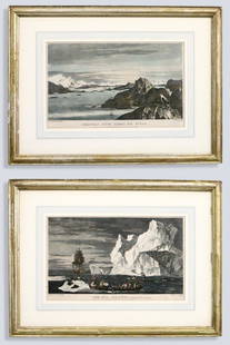
Sold20232 After Hodges Seascape EngravingsAfter William Hodges, British, 1744-1797. Two 18th century engraved seascapes on paper with hand-coloring from "A Voyage Towards the South Pole and Round the World..." by Captain James Cook. Titled "CSee Sold Price
Sold2019Carte de l'isle O-Taïti. Tahiti, Moorea & Marquesas.TITLE/CONTENT OF MAP: '[Cook 3e Voyage] Carte de l'isle O-Taïti // Plan des Havres, situés au côté Nord d'Eimeo // Baye Matavai dans O-Tahïti // Carte des Marquises de Mendoce [Cook's 3rd VoyageSee Sold Price
Sold2019Carte de la rivière de Cook. Cook Inlet & Alaska coast.TITLE/CONTENT OF MAP: '[Cook 3e Voyage] Carte de la rivière de Cook, dans la partie Nord-Ouest de l Amérique // Plan du Havre de Samgano odha, dans l'Isle de Oonalaska [Cook's 3rd Voyage - Map of CoSee Sold Price
Sold2023Côte NO de l'Amérique & côte NE de l’Asie. Alaska & Kamchatka. BONNE 1790 mapTITLE/CONTENT OF MAP: [Cook 3e Voyage] Carte de la côte Nord-Ouest de l'Amérique et de la côte Nord-Est de l’Asie // Plan de l'Entrée de Nootka [Cook's 3rd Voyage - Map of thSee Sold Price
Sold2024Côte NO de l'Amérique & côte NE de l’Asie. Alaska & Kamchatka. BONNE 1788 mapTITLE/CONTENT OF MAP: [Cook 3e Voyage] Carte de la côte Nord-Ouest de l'Amérique et de la côte Nord-Est de l’Asie // Plan de l'Entrée de Nootka [Cook's 3rd Voyage - Map of thSee Sold Price
Sold2024Entrée de Norton & Détroit de Bhering. Bering Strait Norton Sound BONNE 1790 mapTITLE/CONTENT OF MAP: [Cook 3e Voyage] Carte de l'entrée de Norton et du Détroit de Bhering, où l'on voit le Cap le plus Oriental de l'Asie et la pointe la plus Occidentale de l'AméSee Sold Price
Sold2015South Pole with Cook's 2nd voyage tracedHeading: Author: Gentleman's Magazine Title: A Map of the South Pole, with the Track of His Majesty's Sloop Resolution in Search of a Southern Continent Place Published: London Publisher: Date PSee Sold Price
Sold2023ENGRAVING OF SOUTH SEAS NATIVE WOMANENGRAVING OF SOUTH SEAS NATIVE WOMAN ATLAS DES VOYAGES DE COOK PARIS-1775, 17 X 13See Sold Price
Sold2018Chart of South Pacific with Cook's routes 1774Heading: Author: Cook, James Title: Carte d'une Partie de la Mer du Sud Contenant les Decouvertes de Vaisseaux de sa Majeste le Dauphin, Commodore Byron, la Tamar, Capitne. Mouats, 1765, le Dauphin,See Sold Price
Sold2022MAP, Southern Alaska, BonneSouthern Alaska. Rigobert Bonne, Carte de la Riviere de Cook dans la Partie N.O. de l'Amerique, from Atlas Encyclopedique, 1787 (circa). Black & White. This handsome map shows Capt. Cook's discoveriesSee Sold Price
Sold2018Bellin: Antique Map of South America, 1758TITLE OF THE MAP: 'Carte de l'Amerique Meridionale Pour l'Histoire Générale des Voyages in 8o.' A map of South America. Marked are Chili (Chile), Patagons (Patagonia), Buenos-Ayres 7 Tucuman (ArgentSee Sold Price
Sold2023MAP, Southeast USA, BellinColonial Southeast United States. Jacques Nicolas Bellin, Carte de la Caroline et Georgie. Pour Servir a l'Histoire Generale des Voyages, from Histoire Generale des Voyages, 1757 (dated). Hand Color.See Sold Price
Sold2021c1758 Hand Colored Map of South AmericaHand colored map of South America by Jacques Bellin published circa 1759 entitled "Carte De L'Amerique Meridionale Pour l'Histoire Generale des Voyages". On fine paper. Light corner creases, else FineSee Sold Price
Sold2018McCORMICK, Robert (1800-1890). Voyages of Discovery inMcCORMICK, Robert (1800-1890). Voyages of Discovery in the Arctic and Antarctic Seas, and Round the World; being the personal narratives of attempts to reach The North and South Poles; and of an Open-See Sold Price
Sold2022Cook's Voyages 1774 Map of Cape Providence, Chile"Cap Providence avec le baye et les mouillages qu'on trouve au N.N.E. de ce Cap" Copper Engraved Map Published 1774, Paris for "Cartes et figures des voyages entrepris par ordre de Sa Majeste BritanniSee Sold Price
Sold20211753 Fine Folding Map of the South SeasMap of the South Seas by Jacques Bellin, Paris, circa 1753. Entitled "Carte Reduite De la Mer Du Sud Pour Servir a l'Histoire generale des Voyages". Fine folding map, close trim to right margin. MeasuSee Sold Price
Sold2021MAP, Southeast Asia, BellinSoutheast Asia. Bellin/Van Schley, Carte des Royaumes de Siam, de Tunquin, Pegu, Ava, Aracan, &c. pour Servir a l'Histoire Generale des Voyages, from Histoire Generale des Voyages, 1760 (circa). HandSee Sold Price
Sold2022Strait of Magellan from French Cook 1778Heading: (South America) Author: Bernard, Jean Frederic Title: Carte du Detroit de Magellan dans laquelle on an Insere les Observations et les Decouvertes du Capne. Byron, du Capne. Wallis, et du CapnSee Sold Price
Sold2019d'Urville, Dumont 1834 Map of the World"Carte General du Voyage Pittoresque autour du Monde" Steel Engraved Map Published 1834 by Chez Furne et Ce, Paris for "Voyage pittoresque autour du Monde - Résumé général des voyages de découverSee Sold Price
Sold2023MAP, Philippines, BellinSouthern Philippines. Jacques Nicolas Bellin, Carte des Isles Philippines Dressee sur la Carte Espagnole du R.P. Murillo de Velarde. 2e. Feuille..., from Histoire Generale des Voyages, 1752 (dated). HSee Sold Price
Jun 02Schilb Antiquarian Rare Books1880 Captain James Cook Voyages Hawaii Pacific Australia Kippis South Sea Navy$1
Featured4 days LeftJasper52Carte de l'Isle St. Christophe'. Saint Kitts/St Christopher. BELLIN 1760 map$130
6 days LeftTrillium Antique Prints & Rare BooksPrevost - Map of the South Pacific Ocean with New Holland (Australia), New Zealand, and part of the$50(1 bid)
6 days LeftTrillium Antique Prints & Rare BooksWebber & Cook, Rare - View of the Harbour of Taloo, in the Islands of Eimeo$500
6 days LeftTrillium Antique Prints & Rare BooksWebber & Cook, Rare - A Toopapaoo of a Chief, with a Priest Making His Offering to the Morai, in$500
3 days LeftJasper521753 Prevost Map of Pacific Wind Currents -- Representation du Cours ordinaire des Vents de Traverse$85
5 days LeftRail & Road AuctionsFive Airline Menus and Advertisement - Air France, Riddle Airlines, American, and Pan American World$20
May 17Royal Treasures Warehouse LLC1530s Old Map of the World as seen from the North & South Poles$100
May 15University ArchivesRare 18th C. French Engraving Showing Chilean Hockey Player & Other Exotic Customs$140


![Cook. A VOYAGE TOWARDS THE SOUTH POLE... 2 Vols.: [Travel] James Cook. A VOYAGE TOWARDS THE SOUTH POLE, AND ROUND THE WORLD. Performed in His Majesty’s Ships the Resolution and Adventure, In the Years 1772, 1773, 1774, and 1775… In which is inclu](https://p1.liveauctioneers.com/179/96603/49249287_1_x.jpg?height=310&quality=70&version=1479429231)


![Carte de l'isle O-Taïti. Tahiti, Moorea & Marquesas.: TITLE/CONTENT OF MAP: '[Cook 3e Voyage] Carte de l'isle O-Taïti // Plan des Havres, situés au côté Nord d'Eimeo // Baye Matavai dans O-Tahïti // Carte des Marquises de Mendoce [Cook's 3rd Voyage](https://p1.liveauctioneers.com/5584/154902/78199490_1_x.jpg?height=310&quality=70&version=1574201574)
![Carte de la rivière de Cook. Cook Inlet & Alaska coast.: TITLE/CONTENT OF MAP: '[Cook 3e Voyage] Carte de la rivière de Cook, dans la partie Nord-Ouest de l Amérique // Plan du Havre de Samgano odha, dans l'Isle de Oonalaska [Cook's 3rd Voyage - Map of Co](https://p1.liveauctioneers.com/5584/147595/74587318_1_x.jpg?height=310&quality=70&version=1565730371)
![Côte NO de l'Amérique & côte NE de l’Asie. Alaska & Kamchatka. BONNE 1790 map: TITLE/CONTENT OF MAP: [Cook 3e Voyage] Carte de la côte Nord-Ouest de l'Amérique et de la côte Nord-Est de l’Asie // Plan de l'Entrée de Nootka [Cook's 3rd Voyage - Map of th](https://p1.liveauctioneers.com/5584/310511/166159558_1_x.jpg?height=310&quality=70&version=1701205563)
![Côte NO de l'Amérique & côte NE de l’Asie. Alaska & Kamchatka. BONNE 1788 map: TITLE/CONTENT OF MAP: [Cook 3e Voyage] Carte de la côte Nord-Ouest de l'Amérique et de la côte Nord-Est de l’Asie // Plan de l'Entrée de Nootka [Cook's 3rd Voyage - Map of th](https://p1.liveauctioneers.com/5584/315733/169293401_1_x.jpg?height=310&quality=70&version=1705443824)
![Entrée de Norton & Détroit de Bhering. Bering Strait Norton Sound BONNE 1790 map: TITLE/CONTENT OF MAP: [Cook 3e Voyage] Carte de l'entrée de Norton et du Détroit de Bhering, où l'on voit le Cap le plus Oriental de l'Asie et la pointe la plus Occidentale de l'Amé](https://p1.liveauctioneers.com/5584/326888/175994368_1_x.jpg?height=310&quality=70&version=1713903186)


![[CIVIL WAR] Black Soldier CDV (1 of 2)](https://p1.liveauctioneers.com/7226/322253/173251672_1_x.jpg?height=282&quality=70&version=1710004847)


![[1833] Cook's Voyages By A. Kippis (1 of 5)](https://p1.liveauctioneers.com/5755/327684/176532997_1_x.jpg?height=282&quality=70&version=1714078974)
![Western Album w/ Lincoln & Rare Views [Kansas] (1 of 2)](https://p1.liveauctioneers.com/7226/322253/173251612_1_x.jpg?height=282&quality=70&version=1710004847)
![Photographer & Camera [CDV] (1 of 1)](https://p1.liveauctioneers.com/7226/322253/173251711_1_x.jpg?height=282&quality=70&version=1710004847)


![[CIVIL WAR] 64th Ohio CDV Album (1 of 5)](https://p1.liveauctioneers.com/7226/325455/175169009_1_x.jpg?height=282&quality=70&version=1712370394)