Sold2018Egypt.- Ortelius (Abraham) Aegyptus Antiqua, two-sheetEgypt.- Ortelius (Abraham) Aegyptus Antiqua, two-sheet map of ancient Egypt, with inset map of Alexandria and its surroundings, the bottom sheet with dedication cartouche to the humanist and medical dSee Sold Price
Sold20222-sheet map of ancient Egypt by Ortelius 1584Heading: Author: Ortelius, Abraham Title: Aegyptus Antiqua Place Published: Antwerp Publisher: Date Published: 1584 Description: Copper engraved map on two sheets, north anSee Sold Price
Sold2022Ortelius, Abraham Islandia [Iceland]Ortelius, Abraham Islandia [Iceland] [Antwerp, c.1590 or later]. Hand-coloured engraved map (platemark 33.5 x 48.5cm, sheet size 43.5 x 55.5cm), incorporating sea-monsters, polar bears and Hekla volcaSee Sold Price
Sold2022ORTELIUS, ABRAHAM. Typus Orbis Terrarum.ORTELIUS, ABRAHAM. Typus Orbis Terrarum. Double-page engraved map of the world. 16¾x20½ inches sheet size, wide margins, Dutch text on verso; original hand-color; professionally conserved wiSee Sold Price
Sold2022ORTELIUS, ABRAHAM. Americae Sive Novi Orbis, Nova Descriptio.ORTELIUS, ABRAHAM. Americae Sive Novi Orbis, Nova Descriptio. Double-page engraved map of the Western Hemisphere. 17½x22¼ inches sheet size, wide margins, Spanish text on verso; uncolored; cSee Sold Price
Sold2022China.- Ortelius (Abraham) Chinae, olim Sinarum regionis, nova descriptio, 1584 [but slightlyChina.- Ortelius (Abraham) Chinae, olim Sinarum regionis, nova descriptio, detailed map centred on China and based on the work of Jorge de Barbuda, a Portuguese Jesuit also known as Ludovicus GeorgiusSee Sold Price
Sold2023ORTELIUS, Abraham (1527-1598). Americae sive Novi Orbis, Nova Descriptio. Antwerp, ca 1572.ORTELIUS, Abraham (1527-1598). Americae sive Novi Orbis, Nova Descriptio. Antwerp, ca 1572. Engraved map of the Americas with hand-coloring in wash and outline, visible area 15 3/4 x 20 3/4 inches (40See Sold Price
Sold2022ORTELIUS, ABRAHAM. 1527-1598. Chinae olim Sinarum regionis. Antwerp: 1584 (but c.1592).ORTELIUS, ABRAHAM. 1527-1598. Chinae olim Sinarum regionis. Antwerp: 1584 (but c.1592). Engraved map with hand-coloring. 407 x 553 mm, on one folio leaf, folded at center, extracted from atlas, with tSee Sold Price
Sold2022British Isles.- Ortelius (Abraham) Britannicarum Insularum Vetus Descriptio, two-sheet map ofBritish Isles.- Ortelius (Abraham) Britannicarum Insularum Vetus Descriptio, two-sheet map of ancient Britain, probably engraved by Jan Wierix, with four ornate strap-work cartouches, a naval battle iSee Sold Price
Sold2018South East Asia.- Ortelius (Abraham) Indiae OrientalisSouth East Asia.- Ortelius (Abraham) Indiae Orientalis Insularumque Adiacientium Typus, map of southern Asia from India across to Java and New Guinea, and including China and Japan to the north, withSee Sold Price
Sold2024[MAP]. ORTELIUS, Abraham. Presbiteri Iohannis, sive, Abissinorum Imperii Descriptio. 1592.[MAP]. ORTELIUS, Abraham. (1527-1598). Presbiteri Iohannis, sive, Abissinorum Imperii Descriptio. Antwerp, 1592. Engraved map with hand-coloring. Matted, framed, and double glazed, visible area 406 xSee Sold Price
Sold2024[MAP]. ORTELIUS, Abraham. Romani Imperii Imago. 1592.[MAP]. ORTELIUS, Abraham (1527-1598). Romani Imperii Imago. Antwerp, 1592. Engraved map with hand-coloring. Matted, framed, and double glazed, visible area 381 x 521 mm (unexamined out of frame). 6 deSee Sold Price
Sold2024[MAP]. ORTELIUS, Abraham. Peregrinationis Divi Pauli Typus Corographicus. 1592.[MAP]. ORTELIUS, Abraham (1527-1598). Peregrinationis Divi Pauli Typus Corographicus. Antwerp, 1592. Engraved map with hand-coloring. Matted, framed, and double glazed, visible area 381 x 533 mm (unexSee Sold Price
Sold2020[Maps & Atlases] [Africa] Ortelius, Abraham, Group of 2[Maps & Atlases] [Africa] Ortelius, AbrahamGroup of 2 MapsBarbariae et Biledulgerid, nova descriptio(Antwerp, ca. 1570-1612). Hand-colored engraving. Coastal map of North Africa and the Mediterranean,See Sold Price
SoldOrtelius, Abraham:Ortelius, Abraham: Maris Pacifici (quod vulgo Mar del Zur) cum regionibus circumiacentibus, insulisque in eodem passim sparsis, novissima descriptio. [Antwerp], 1589 [but Later]. 34 x 49cm. Hand-coloSee Sold Price
Sold2020ORTELIUS, ABRAHAM. Septentrionalium Regionum Descrip.ORTELIUS, ABRAHAM. Septentrionalium Regionum Descrip. Double-page engraved map of Scandinavia, Greenland, Iceland and a northeastern portion of North America. 17½x22¼ inches sheet size, wideSee Sold Price
Sold2022ORTELIUS, ABRAHAM; and PHILILLPE GALLE. Set of 5 miniature maps of the world and continents.ORTELIUS, ABRAHAM; and PHILILLPE GALLE. Set of 5 miniature maps of the world and continents. Engravings with original hand-color. 4x5½ inches each sheet size, Latin text on verso; light finger soSee Sold Price
Sold2024[MAP]. ORTELIUS, Abraham. Africae Tabula Nova. 1592.[MAP]. ORTELIUS, Abraham (1527-1598). Africae Tabula Nova. Antwerp, 1592. Engraved map with hand-coloring. Matted, framed, and double glazed, visible area 406 x 533 mm (unexamined out of frame). StrapSee Sold Price
Sold2022Africa.- Ortelius (Abraham) Africae Tabula Nova, engraved map, [c.1570-1612].Africa.- Ortelius (Abraham) Africae Tabula Nova, detailed map of Africa based upon Gastaldi's 8 sheet wall map and Mercator's world map of 1569, decorated with a strapwork title cartouche, a sea battlSee Sold Price
Sold2020Africa.- Ortelius (Abraham) Africae Tabula Nova, [c.Africa.- Ortelius (Abraham) Africae Tabula Nova, map of the African continent, with Madagascar and part of the Arabian Gulf, Zanzibar is shown on the west coast, decorated with a large strapwork titleSee Sold Price
Sold2020Ortelius (Abraham), Angliae, Scotiae et Hiberniae, SiveOrtelius (Abraham) Angliae, Scotiae et Hiberniae, Sive Britannicar Insularum Descriptio, copper engraved map, from Ortelius’ ‘Theatrum Orbis Terrarum’, hand coloured, Royal coat ElSee Sold Price
Sold2024[MAP]. ORTELIUS, Abraham. Turcici Imperii Descriptio.1592.[MAP]. ORTELIUS, Abraham (1527-1598). Turcici Imperii Descriptio. Antwerp, 1592. Engraved map with hand-coloring. Matted, framed, and double glazed, sight 406 x 521 mm (unexamined out of frame). DecorSee Sold Price
Sold2020[Maps & Atlases] [North Atlantic] Ortelius, Abraham,[Maps & Atlases] [North Atlantic] Ortelius, AbrahamSeptentrionalium regionum descrip.(Antwerp, 1603). Hand-colored engraving. Latin text on verso. Center fold verso reinforced with japanese paper. 16See Sold Price
Sold2018France.- Ortelius (Abraham) Gallia, detailed map ofFrance.- Ortelius (Abraham) Gallia, detailed map of France, with part of southern England, northern Italy, and includes Belgium and the Netherlands, a large title cartouche with two putto decorating tSee Sold Price
3 days LeftMynt AuctionsAbraham Lincoln Signed & Framed 1.75x7.75 Handwritten Receipt BAS #AB14364$330(3 bids)
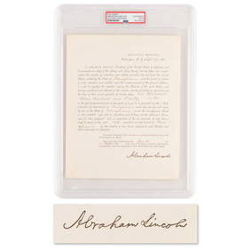
4 days LeftRR AuctionAbraham Lincoln Document Signed as President, Ordering Pennsylvania to Furnish Additional Troops for$1,000
Oct 02Potter & Potter Auctions[WAX FIGURE]. Abraham Lincoln Seated Figure. (American, 20t...$400(2 bids)
4 days LeftRR AuctionAbraham Lincoln Signed Check - PSA MINT 9 - to a Springfield book publisher, who he approached about$1,600(2 bids)
Oct 04South Florida Auction & Estate Sale Services IncABRAHAM LINCOLN Autograph Edition Studio Portrait Card$6(1 bid)
5 days LeftCurated Gallery AuctionsAbraham Straski (1903 - 1987) Antique Signed Polish Realist Jewish Violin Player Framed Oil Painting$40(3 bids)
Oct 16Joe R. Pyle Complete Auctions & Real EstateAbraham Lincoln Last Official CDV Photograph Taken Before Killed$110(3 bids)
5 days LeftEstate Collection Auctioneer1988 Photography. Landscape Parable of the Tares 1624 Painting Abraham Bloemaert$350
2 days LeftRichard L. Edwards Auctioneering1837 Abraham Lincoln Presidential Dollar Series Coin (Part of the Presidential Coin Set)$1
4 days LeftRR AuctionLincoln Assassination: Rare Original Reward Broadside Poster for John Wilkes Booth and Conspirators:$5,000


![Ortelius, Abraham Islandia [Iceland]: Ortelius, Abraham Islandia [Iceland] [Antwerp, c.1590 or later]. Hand-coloured engraved map (platemark 33.5 x 48.5cm, sheet size 43.5 x 55.5cm), incorporating sea-monsters, polar bears and Hekla volca](https://p1.liveauctioneers.com/94/251108/130828919_1_x.jpg?height=310&quality=70&version=1655281539)


![[MAP]. ORTELIUS, Abraham. Presbiteri Iohannis, sive, Abissinorum Imperii Descriptio. 1592.: [MAP]. ORTELIUS, Abraham. (1527-1598). Presbiteri Iohannis, sive, Abissinorum Imperii Descriptio. Antwerp, 1592. Engraved map with hand-coloring. Matted, framed, and double glazed, visible area 406 x](https://p1.liveauctioneers.com/197/329395/177650536_1_x.jpg?height=310&quality=70&version=1715364962)
![[MAP]. ORTELIUS, Abraham. Romani Imperii Imago. 1592.: [MAP]. ORTELIUS, Abraham (1527-1598). Romani Imperii Imago. Antwerp, 1592. Engraved map with hand-coloring. Matted, framed, and double glazed, visible area 381 x 521 mm (unexamined out of frame). 6 de](https://p1.liveauctioneers.com/197/329395/177650537_1_x.jpg?height=310&quality=70&version=1715364962)
![[MAP]. ORTELIUS, Abraham. Peregrinationis Divi Pauli Typus Corographicus. 1592.: [MAP]. ORTELIUS, Abraham (1527-1598). Peregrinationis Divi Pauli Typus Corographicus. Antwerp, 1592. Engraved map with hand-coloring. Matted, framed, and double glazed, visible area 381 x 533 mm (unex](https://p1.liveauctioneers.com/197/329395/177650535_1_x.jpg?height=310&quality=70&version=1715364962)
![[Maps & Atlases] [Africa] Ortelius, Abraham, Group of 2: [Maps & Atlases] [Africa] Ortelius, AbrahamGroup of 2 MapsBarbariae et Biledulgerid, nova descriptio(Antwerp, ca. 1570-1612). Hand-colored engraving. Coastal map of North Africa and the Mediterranean,](https://p1.liveauctioneers.com/65/180189/90674454_1_x.jpg?height=310&quality=70&version=1601308774)
![Ortelius, Abraham:: Ortelius, Abraham: Maris Pacifici (quod vulgo Mar del Zur) cum regionibus circumiacentibus, insulisque in eodem passim sparsis, novissima descriptio. [Antwerp], 1589 [but Later]. 34 x 49cm. Hand-colo](https://p1.liveauctioneers.com/1782/326783/175979823_1_x.jpg?height=310&quality=70&version=1714059004)


![[MAP]. ORTELIUS, Abraham. Africae Tabula Nova. 1592.: [MAP]. ORTELIUS, Abraham (1527-1598). Africae Tabula Nova. Antwerp, 1592. Engraved map with hand-coloring. Matted, framed, and double glazed, visible area 406 x 533 mm (unexamined out of frame). Strap](https://p1.liveauctioneers.com/197/329395/177650533_1_x.jpg?height=310&quality=70&version=1715364962)
![Africa.- Ortelius (Abraham) Africae Tabula Nova, engraved map, [c.1570-1612].: Africa.- Ortelius (Abraham) Africae Tabula Nova, detailed map of Africa based upon Gastaldi's 8 sheet wall map and Mercator's world map of 1569, decorated with a strapwork title cartouche, a sea battl](https://p1.liveauctioneers.com/5458/269991/141255679_1_x.jpg?height=310&quality=70&version=1669303305)


![[MAP]. ORTELIUS, Abraham. Turcici Imperii Descriptio.1592.: [MAP]. ORTELIUS, Abraham (1527-1598). Turcici Imperii Descriptio. Antwerp, 1592. Engraved map with hand-coloring. Matted, framed, and double glazed, sight 406 x 521 mm (unexamined out of frame). Decor](https://p1.liveauctioneers.com/197/329395/177650538_1_x.jpg?height=310&quality=70&version=1715364962)
![[Maps & Atlases] [North Atlantic] Ortelius, Abraham,: [Maps & Atlases] [North Atlantic] Ortelius, AbrahamSeptentrionalium regionum descrip.(Antwerp, 1603). Hand-colored engraving. Latin text on verso. Center fold verso reinforced with japanese paper. 16](https://p1.liveauctioneers.com/65/180189/90674457_1_x.jpg?height=310&quality=70&version=1601308772)


![[WAX FIGURE]. Abraham Lincoln Seated Figure. (American, 20t... (1 of 4)](https://p1.liveauctioneers.com/928/342606/186002853_1_x.jpg?height=282&quality=70&version=1725643038)


![[LINCOLN] General's Commission Signed by Lincoln (1 of 3)](https://p1.liveauctioneers.com/7226/343679/186654896_1_x.jpg?height=282&quality=70&version=1726945754)