Sold20211653 Merian Map of Northern Germany -- MeklenburgTitle: 1653 Merian Map of Northern Germany -- Meklenburg Ducatus Cartographer: Merian [family] Year / Place: 1653, Frankfurt Map Dimension (in.): 10.8 X 14.1 in. This is a very handsome map of the hisSee Sold Price
Sold2023Baedeker, Karl 1904 Lot of 25 Antique Maps. Northern GermanyLithograph Maps Published 1904, Leipzig for "Northern Germany as far as the Bavarian and Austrian Frontiers. Handbook for Travellers" by Karl Baedeker. Folds as issued. Paper Size: Up to 13 x 13 inchSee Sold Price
Sold20221716 Homann Map of Northern Germany with Hamburg --Title: 1716 Homann Map of Northern Germany with Hamburg -- Tabula Generalis Holsatiae Complectens Holsatiae, Dithmarsiae, Stormariae, et Vagriae Ducatus Cartographer: J Homann Year / Place: 1716, NurnSee Sold Price
Sold20211630 Blaeu/Hondius Map of Northern Germany -- DucatusTitle: 1630 Blaeu/Hondius Map of Northern Germany -- Ducatus Holsatiae nova tabula Cartographer: Blaeu/Hondius Year / Place: 1630, Amsterdam Map Dimension (in.): 15 X 20.1 in. This is a lovely double-See Sold Price
Sold20241630 Mercator Map of Northern Germany -- Saxonia Inferior et Meklenborg Duc:Title: 1630 Mercator Map of Northern Germany -- Saxonia Inferior et Meklenborg Duc: Cartographer: G Mercator Year / Place: 1630, Amsterdam Map Dimension (in.): 7.2 X 9.8 in. This is an excellent map oSee Sold Price
Sold2022Original Antique Map - Mecklenburg-Schwerin - Map of Northern GermanyAntique outline hand colored map from edition of Meyer’s world atlas, edited by Ludwig Ravenstein, published by Bibliographic Institute in 1872. Technique: Engraving. Place: Leipzig, Germany. SSee Sold Price
Sold2017Isaac Tirion: Antique Map of Northern Germany, 1740Title: Map of Northern Germany by Isaac Tirion Date: 1740-62 Medium: Wax Engraving Dimensions (in.): 14 x 12 No Reserve: This lot starts at $1 and has no reserve as a courtesy so that collectors can dSee Sold Price
Sold2023Baedeker, Karl 1900 Lot of 94 Maps of Northern Germany & AustriaLithograph Maps Published 1900, Leipzig for "Northern Germany as far as the Bavarian and Austrian Frontiers" by Karl Baedeker. Folds as issued. Paper Size: Up to 18 x 12 inch (46 x 30cm) Good ConditioSee Sold Price
Sold20191836 Tanner Map of Prussia / Northern Germany --Title/Content of Map: 1836 Tanner Map of Prussia / Northern Germany -- Prussia Cartographer: H S Tanner Size: 12 x 14.7 in. An attactive map Prussia, showing topographical and settlement details. TheSee Sold Price
Sold20171753 Homann Map Of DenmarkJ. Homann, 1753 Nurnberg, 19.2 x 22.4 in. This handsome Homann Denmark map also includes northern Germany and southern Sweden. Fantastic amount of topographical and settlement details are offered. TheSee Sold Price
Sold2015Jansson (Jan) - [Atlas Novus: Germany],single vol. lacking title, 106 mostly regional maps of Germany and northern Europe, but also including a general map of Germany, and classical maps of both Germany and Scandinavia, and several city plSee Sold Price
Sold20201720 c. Homann Map of Belgium, Northern France andTitle/Content of Map: 1720 c. Homann Map of Belgium, Northern France and Western Germany -- Arena Martis in Belgio, Qua Provinciae X. Catholicae Inferioris Germaniae Cartographer: J Homann Year/Place:See Sold Price
Sold20201748 Le Rouge Map of Southern Germany and NorthernTitle: 1748 Le Rouge Map of Southern Germany and Northern Switzerland -- La Souabe Aparis par et Chez le St. le Rouge Geo. du Roy rue des Grands Augistins Year/Place: 1748, Paris Cartographer: G Le RoSee Sold Price
Sold2021Early colored Map Archbishop of MainzEarly colored Map Archbishop of Mainz Electorate(Germany) Northern Offices, titled “Des Erzstifts und Kurfürstenthums Mainz Nördliche Aemter Nro.224”, 9" x 14"See Sold Price
Sold2022Early 20th c Travel Guides w/ MapsEarly 20th c travel guides with fold-out maps (8 pcs), including Baedecker's Central Italy, Northern Italy, Northern Germany, Paris and Environs, London and Environs, Switzerland, Bennett's Norway (2See Sold Price
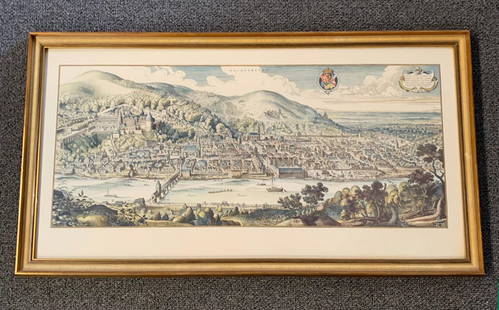
Sold20201620 Hand-colored Copperplate Engraved Haidelberga MapHeidelberg-Panorama von Matthaeus Merian 1620 - Description''': historic views of Heidelberg, Germany Birds Eye View Heidelberg 1620 Rare Copperplate Engraving by Matthäus Merian MAP - MatthäusSee Sold Price
Sold2020Rapkin, John 1860 Lot of 5 British & European MapsIncl Scotland, Germany, England/Wales, Denmark and Northern Italy. Steel Engraved Maps Published 1860 by The London Printing & Published Company, London for "The Royal Dictionary-Cyclopedia for UniverSee Sold Price
Sold2019Encyclopaedia Britannica 1911 Mixed Lot of 16 MapsIncl French West Africa, Turkestan, French Indo-China & Siam, Germany, Central America, Northern/Southern Hemisphers, Ireland, Polar Regions, Denmark, France, Norway/Sweden, Spain and Portugal, FranceSee Sold Price
Sold2021Tallis, John (Pub) 1852 Lot of 12 European MapsIncl Northern Italy, Southern Italy, Brussels, Germany, Spain and Portugal, Prussia, Europe Continent, Greece, Denmark, Belgium, Holland and France. Steel Engraved Maps with Original Outline Hand ColoSee Sold Price
Sold2019Stieler, Adolf 1879 Pair of Celestial Maps. Star Charts"Der Sudliche Stern-Himmel" and "Der Nordliche Stern-Himmel" Southern and Northern Constellations. Steel Engraved Map Published 1879, Gotha, Germany for "Hand-Atlas über alle Theile der Erde und übeSee Sold Price
Sold2020Bartholomew, John 1922 Lot 7 Maps. Baltic, Germany etcIncl Germany West, Germany East, Southern Scandinavia/Denmark, Poland/Czecho-Slovakia, Siberia, Northern Russia/Finland, Baltic States/East Prussia. Large Lithograph Maps Published 1922 by The Times,See Sold Price
Sold2019Bartholomew, John 1922 Lot of 8 Large Maps of EuropeIncl Belgium/Holland, Spain/Portugal - East & West, Northern Italy/Austria, Southern Italy, Central European States, Germany - South & West. Large Lithograph Maps Published 1922 by The Times, London fSee Sold Price
Sold2022A gothic oak two-door cupboard with linenfold panels, Northern Germany, 16th C.Full title: A gothic oak two-door cupboard with linenfold panels, Northern Germany, 16th C. Description: H 132,5 x L 88 x D 63 cm About this sale: Paul De Grande is one of the major dealers of antiqueSee Sold Price
Sold2021Jansson 1653 Map of British IslesDESCRIPTION: " Magnae Brittaniae et Hiberniae Nova Descriptio. " Based on Willem Blaeu's 1631 map of the British Isles, this map depicts towns, rivers, an inset of Orkney Islands. Strap work cartoucheSee Sold Price
5 days LeftJasper521792 Elwe Map of Southern Netherlands to Belgium to Northern France -- Carte Nouvelle des Pais Bas$80
5 days LeftJasper521792 Elwe Map of the Netherlands and Belgium -- Les Dix-Sept Provinces des Pays-Bas$80
May 12Schilb Antiquarian Rare Books1859 AFRICA VOYAGES Barth Timbuktu Tripoli SLAVES Illustrated Slavery MAP African$62(4 bids)
1 day LeftJay Anderson AuctionCirca 1920 Black Forest Carved Elk signed Germany on the base. Hgt 14" L 8" w 2.75". All in good$50(1 bid)
May 14Akiba Galleries(2 Pc) Allain Manesson Mallet Description De L'Univers 2 Vol. German Translation$200(1 bid)
5 days LeftJasper521775-1780 French Guiana. Dutch Guiana and Northern Brazil. By Bonne and Raynal.$30
5 days LeftJasper521775-1780 Uruguay, Northern Argentina, Southern Brazil, and Rio de Janeiro. By Bonne & Raynal$30


![1653 Merian Map of Northern Germany -- Meklenburg: Title: 1653 Merian Map of Northern Germany -- Meklenburg Ducatus Cartographer: Merian [family] Year / Place: 1653, Frankfurt Map Dimension (in.): 10.8 X 14.1 in. This is a very handsome map of the his](https://p1.liveauctioneers.com/5584/195879/98794817_1_x.jpg?height=310&quality=70&version=1614724478)


![Jansson (Jan) - [Atlas Novus: Germany],: single vol. lacking title, 106 mostly regional maps of Germany and northern Europe, but also including a general map of Germany, and classical maps of both Germany and Scandinavia, and several city pl](https://p1.liveauctioneers.com/410/80717/41962763_1_x.jpg?height=310&quality=70&version=1445353131)