Sold20211750 Robert de Vaugondy Map of Russia in Large Part --Title: 1750 Robert de Vaugondy Map of Russia in Large Part -- Partie Occidentale de l'Empire de Russie ou se trouve distinguee la Russie Europeenne … Cartographer: D Robert de Vaugondy Year / Place:See Sold Price
Sold20221750 Robert de Vaugondy Map of Russian Empire -- PartieTitle: 1750 Robert de Vaugondy Map of Russian Empire -- Partie Occidentale de l'Empire de Russie, ou se Trouve Distinguee la Russie Europeenne… Cartographer: D Robert de Vaugondy Year/Place: 175See Sold Price
Sold20211753 Robert de Vaugondy Map of European RussiaTitle: 1753 Robert de Vaugondy Map of European Russia's Northern Portion -- Partie Septentrionale de la Russie Europeenne ou sont distinguees exactement toutes le ProvincesÂ… Cartographer: D RobertSee Sold Price
Sold20231755 Robert De Vaugondy Map of North America Large1755 Robert De Vaugondy Map of America. Mid-Atlantic, New York, New Jersey, Pennsylvania Virginia, Maryland, New England, Carolina and Ohio. Partie De L'Amerique Septentrionale. Map in matte is aboutSee Sold Price
Sold2023Amérique Méridionale. South America. ROBERT DE VAUGONDY 1750 old antique mapTitle: "Amérique Méridionale". South America. ROBERT DE VAUGONDY 1750 old antique map Description: Amérique Méridionale, dressée, sur les Mémoires les plus récents et assujétieSee Sold Price
Sold2021French Hand-Colored Map of America, 1750Antique French Hand-Colored Map of America , "Amerique Septentrionale, dressee, sur les Relations les plus modernes...", 1750, Robert de Vaugondy, the cartouche with an alligator flanked by figures, 1See Sold Price
Sold20201753 Robert de Vaugondy Map of Egypt -- Carte deTitle/Content of Map: 1753 Robert de Vaugondy Map of Egypt -- Carte de L'Egypte Ancienne et Moderne… Cartographer: G Robert de Vaugondy Year/Place: 1753 Size: 25.1 X 18.3 in. This is a large, attracSee Sold Price
Sold2021ROBERT DE VAUGONDY MAP OF SOUTH AMERICA, C. 1750Robert de Vaugondy (French, 1686-1766). "Amerique Meridionale" -1750, engraving with hand coloring. Approx. 20" x 24.75' (sheet)See Sold Price
Sold2024Robert de Vaugondy - Map of Canada - Mer de l' Ouest or Sea of the West and a Northwest PassageThis is the uncommon third state of this map that first appeared in 1762. The title has been amended to acknowledge the new United States and to include the imprint of Delamarche. A large inset map coSee Sold Price
Sold2020Amerique Septentrionale.Amerique Septentrionale. Hand-colored engraved map by Robert de Vaugondy, 1750 18.75" x 23" Frame: 29" x 33.75"See Sold Price
Sold20164 Maps: 1760 N. Am.; Botanic Geo.; Eur.; OK Terr.Four Antique Maps; a French 1760 Map of North American ''AMÉRIQUE SEPTENTRIONALE...1750'' Paris: S. Robert De Vaugondy, c. 1750 (1st edition, dated in the cartouche; "Outlines of Botanical Geography"See Sold Price
Sold2015Map of Spain, Robert de VaugondyHispania Antiqua map of Spain. Robert de Vaugondy, 1750. [Sight: 19 1/4" x 22 1/2"; Frame: 25 1/2" H x 29" W]. Frame missing glass. Creases and water damage.See Sold Price
Sold2017Vaugondy: Antique Map of Western Hemisphere, 1750sTitle/Content of Map: 1750's Western Hemisphere Date Printed: 1750's Cartographer: Robert de Vaugondy Material/Medium: Paper Size: 6" x 8" Hand colored copperplate engraved. Published in Paris. GillesSee Sold Price
Sold2020Map, Robert de VaugondyRobert de Vaugondy (French, 1688-1766), "Royaume d'Irlande divise en ses quatre Provinces," 1750, hand-colored engraving, sight (image): 19.5"h x 21.5"w, overall (with frame): 27"h x 29"w. Provenance:See Sold Price
Sold2021Map- Robert de Vaugondy (1723-1786, French). "AmeriqueMap- Robert de Vaugondy (1723-1786, French) "Amerique Septentrionale," 1750, hand colored, with a cartouche of Tropical plants, natives and wildlife surrounding the title, shrink wrapped, H.- 21 3/8 iSee Sold Price
Sold2022A Vaugondy map of Virginia and Maryland, 1755A large map of Virginia and Maryland, titled Carte de la Virginie et du Maryland by Robert de Vaugondy (1755) after the map by Peter Jefferson and Joshua Fry. On laid paper, with a fold crease down thSee Sold Price
Sold2023AFTER NICOLAS SANSON (FRENCH, 1600-1667) MAP OF GREAT BRITAINAFTER NICOLAS SANSON (FRENCH, 1600-1667) MAP OF GREAT BRITAIN, hand-colored engraving on laid paper, engraving by Robert De Vaugondy. Unframed. Circa 1750. 21 3/4" x 31". Provenance: BSee Sold Price
Sold2018AsieMap: Asie Date: 1750 Cartographer: ROBERT DE VAUGONDY, GILLES Size (inches): 5.8X6.3 "Par le Sr. Robert de Vaugondy, avec privilege 1750." No.14 of a series used in a geography. On polar projection. SSee Sold Price
Sold2018AsieMap: Asie Date: 1750 Cartographer: ROBERT DE VAUGONDY, GILLES Size (inches): 5.8X6.3 "Par le Sr. Robert de Vaugondy, avec privilege 1750." No.14 of a series used in a geography. On polar projection. SSee Sold Price
Sold2018AsieTitle/Content of Map: Asie Date: 1750 Cartographer: ROBERT DE VAUGONDY, GILLES Size: 5.8X6.1 "Par le Sr. Robert de Vaugondy, avec privilege 1750." Please note that this lot has a confidential reserve.See Sold Price
Sold2019PologneTitle/Content of Map: Pologne Date: 1762 Cartographer: ROBERT DE VAUGONDY, GILLES | MEUNIER, sc. Size: 6Height - 6.75Width Par le Sr. Robert de Vaugondy, avec privilege 1750. No. 11 of a series used iSee Sold Price
Sold2023 [MAPS - COLONIAL NORTH AMERICA]. VAUGONDY, Gilles Robert de...[MAPS - COLONIAL NORTH AMERICA]. VAUGONDY, Gilles Robert de (1688-1766). Partie de l'Amerique Septentrionale qui Compred le Cours de l'Ohio… Paris, 1755. Large hand-colored engraved map (520 x 6See Sold Price
Sold2018A Hand Colored Map on Laid Paper of 'Royaume D'Irlande'A Hand Colored Map on Laid Paper of 'Royaume D'Irlande' by Gilles Robert de Vaugondy (1688-1766), Published in Paris, ca. 1750. Framed dimensions: h: 29 1/4 x w: 30 5/8 in. H: 19 14 W: 21 1/2 in. TheSee Sold Price
Sold2017Vaugondy: Antique Map of Europe, 1750Map: L'europe Publication Date: 1750 Authors: ROBERT DE VAUGONDY, DIDIER Size: Miniature – 5.75 H x 5.80 W Inches Par le Sr. Robert de Vaugondy avec privilege du roi 1750. Page 55 of a series used iSee Sold Price
5 days LeftJasper521753 Robert de Vaugondy Map of Central France -- Gouvernemens Generaux De La Marche, Du Limosin Et$45
May 14Fleischer's Auctions1755 Map Partie de l'Amerique Septentrionale, qui comprend Le Cours de L'Ohio...$200(3 bids)
2 days LeftTrillium Antique Prints & Rare BooksDe Jode, Rare, pub. 1593 - Map of Part of Germany (Sveviae Utriusq cum Germicae tum Rheticae$100
7 days LeftHunt and Peck Estate Services, Inc.Jacques Nicolas Bellin Map Of Western Part Of New France Or Canada$200(1 bid)
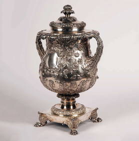
3 days LeftTremont AuctionsMiniature Russian enameled silver triptych icon. Small hinged 3-part icon. Marked 84 on front side$175(2 bids)
May 14Akiba Galleries(2 Pc) Allain Manesson Mallet Description De L'Univers 2 Vol. German Translation$200(1 bid)
2 days LeftGrogan & CompanyROBERT DE NIRO SR., (American, 1922-1993), Still Life with Flowers and Fruit Plate, 1971$1,200(1 bid)
May 14Hermann Historica GmbHA very rare and large Russian icon showing psalm 148 "Praise the Lord from the Heavens" (A call for€4,400
3 days LeftTremont AuctionsAbraham Louis Ducros, attributed to. Swiss/French. "Thermes de Caracalla." Large watercolor painting$500(1 bid)


![Map of Spain, Robert de Vaugondy: Hispania Antiqua map of Spain. Robert de Vaugondy, 1750. [Sight: 19 1/4" x 22 1/2"; Frame: 25 1/2" H x 29" W]. Frame missing glass. Creases and water damage.](https://p1.liveauctioneers.com/1221/80855/42002881_1_x.jpg?height=310&quality=70&version=1445535329)


![[MAPS - COLONIAL NORTH AMERICA]. VAUGONDY, Gilles Robert de...: [MAPS - COLONIAL NORTH AMERICA]. VAUGONDY, Gilles Robert de (1688-1766). Partie de l'Amerique Septentrionale qui Compred le Cours de l'Ohio… Paris, 1755. Large hand-colored engraved map (520 x 6](https://p1.liveauctioneers.com/928/301544/160920952_1_x.jpg?height=310&quality=70&version=1694462960)


![[Gettysburg] Pickett's Charge Survivor (1 of 2)](https://p1.liveauctioneers.com/7226/325455/175169130_1_x.jpg?height=282&quality=70&version=1712370394)


