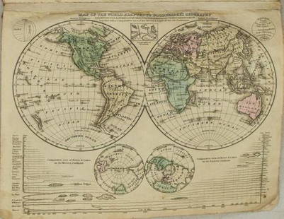
Sold20241822 Woodbridge World Map -- The WorldTitle: 1822 Woodbridge World Map -- The World Cartographer: W. Woodbridge Year / Place: 1822, Hartford Map Dimension (in.): 9.4 X 12.3 in. page This is a very nice double hemisphere world map. It alsoSee Sold Price
Sold20211831 Woodbridge World Map -- Map of the World AdaptedTitle: 1831 Woodbridge World Map -- Map of the World Adapted to Woodbridge's Geography Cartographer: W. Woodbridge Year / Place: 1831, Hartford Map Dimension (in.): 8.6 X 10.8 in. This is a very niceSee Sold Price
Sold2020Framed 1822 World Map, FrenchDated 1822 world map in frame. This map is hand colored and tilted Mappemomde (French for a map showing two hemispheres). This map is double matted in contemporary frame.Condition: very good conditionSee Sold Price
Sold20181843 William Woodbridge World Map1843 William C. Woodbridge Moral and Political Chart of the Inhabited World. Measures 12" x 17.5" (sheet size). G-Vg/Vg condition. Unframed, loose and not mounted or glued down. We ship all items in tSee Sold Price
Sold20231821 Woodbridge Thematic World Map -- Moral and Political Chart Of The Inhabited World ...Title: 1821 Woodbridge Thematic World Map -- Moral and Political Chart Of The Inhabited World ... Cartographer: W. Woodbridge Year / Place: 1831, Hartford Map Dimension (in.): 8.2 X 10.8 in. This is aSee Sold Price
Sold20211821 Woodbridge Thematic World Map of Type ofTitle: 1821 Woodbridge Thematic World Map of Type of Inhabitation -- Chart of the Inhabited World Exhibiting the Prevailing Religion, form of Government, Degree of Civilization and Population... CartoSee Sold Price
Sold20211821 Woodbridge Thematic World Map -- Moral andTitle: 1821 Woodbridge Thematic World Map -- Moral and Political Chart Of The Inhabited World ... Cartographer: W. Woodbridge Year / Place: 1831, Hartford Map Dimension (in.): 8.2 X 10.8 in. This is aSee Sold Price
Sold2020Antique View and MapColossus of Rhodes. View of one of seven Wonders of Ancient World. Antique engraving. With antique double hemisphere world map, published London, 1822. Sights 10 1/2" x 16 1/2" and 7" x 9".See Sold Price
Sold2018Antique Pair Of Maps Of America & The WorldAntique Pair Of Maps Of United States & World, these antique maps are both from W.C. Woodbridge, one map is a world map of the inhabited world, the other is a map of America, the prints have matting bSee Sold Price
Sold2018Jededian Morse atlas 1822Heading: Author: Morse, Jedediah & Sidney Morse Title: A New Universal Atlas of the World; Comprising, in Twenty Maps, Carefully Prepared, From the Latest Information, and Neatly Engraved, The World,See Sold Price
Sold2019Moral and Political Chart of the Inhabited WorldReserve Reduced! Title/Content of Map: Moral and Political Chart of the Inhabited World Date: c1845 Cartographer: WOODBRIDGE, WILLIAM CHANNING Material/Medium: BELKNAP AND HAMERSLEY Size: 8.25Height -See Sold Price
Sold20221823 Woodbridge Maps of Climate, Vegetation and AnimalsTitle: 1823 Woodbridge Maps of Climate, Vegetation and Animals of the World -- Isothermal Chart or View of Climates & Production… Cartographer: W. Woodbridge Year / Place: 1823, Hartford Map DimSee Sold Price
Sold20241831 Woodbridge Maps of Climate, Vegetation and Animals of the World -- Isothermal Chart or View ofTitle: 1831 Woodbridge Maps of Climate, Vegetation and Animals of the World -- Isothermal Chart or View of Climates & Productions… [verso] Chart of the Principal Animals of the World CartographeSee Sold Price
Sold20231831 Woodbridge Maps of Climate, Vegetation and Animals of the World -- Isothermal Chart or View ofTitle: 1831 Woodbridge Maps of Climate, Vegetation and Animals of the World -- Isothermal Chart or View of Climates & Productions… [verso] Chart of the Principal Animals of the World CartographeSee Sold Price
Sold2017Tallis World Map World on Mercator's Projection 1851Tallis World Map The World on Mercator's Projection 1851 . J. Tallis, 1851 London, 10.5 X 14 In.. This Is a Decorative and Striking Steel Engraved World Map That Was Produced from the Same Plate UsedSee Sold Price
Sold2016Map of Cleveland, Cram's Unrivaled Atlas of the WorldMap: Map of Cleveland Maker: George Franklin Cram From: Cram's Unrivaled Atlas of the World Map Origin: Chicago Date: 1889 Medium: Original lithograph printed in color Size: 11.5 x 14.5 inches PleaseSee Sold Price
Sold2016T-O World Map.- Lucanus (Marcus Annaeus) Pharsalia,Lucanus (Marcus Annaeus) Pharsalia, manuscript on paper, [Northern Italy (possibly Padua), first half of the fifteenth century]. 294 x 217mm., I + 149 + I leaves (including defective leaves and 3 blanSee Sold Price
Sold2024Petrus Plancius, Engraved World MapOrbis Terrarum Typus de Integro Multis in Locis Emendatus. Petrus Plancius (1552-1622). Copper-plate engraving with original hand color in full. Amsterdam, 1594. Some stains, creases, folds. Sight sizSee Sold Price
2022Blaeu, Johannes (Netherlands, 1596-1673) "The New World Map" Double Hemisphere World Map C. 1664Nova et Accuratissima Totius Terrarum Orbis Tabula Translated "The New World Map", Hand Colored w/ Elaborately Decorated Spandrels.   Sight View 16" x 21-1/2", Overall View 21" x 25-1/2"See Sold Price
Sold2018Ortelius' 1570 world mapHeading: Author: Ortelius, Abraham Title: Typus Orbis Terrarum Place Published: Antwerp Publisher: Date Published: 1570-[1584?] Description: Copper-engraved map, hand-colorSee Sold Price
2018Important World Map from the Nuremberg Chronicle, 1493Title/Content of Map: World Map from the Nuremberg Chronicle. One of the most important world Maps ever produced Date Printed: 1493 Cartographer: Hartmann Schedel Material/Medium: Paper Size: 18" x 25See Sold Price
Sold2023A Witco Tiki Art World MapWorld Map mixed media sculpture mid century modern Witco 37.25 x 62.25 inches Overall very good condition.See Sold Price
Sold2017World mapWorld map 'Nova Totius Terraum Orbis Geographica Ac Hydrographica Tabula', copper engraving map of Heinrich Hondius, dated 1630,two hemispheres the world map, surrounded by rich allegorical representaSee Sold Price
Sold2020Mercator World Map*** START PRICE IS THE RESERVE *** [World] MERCATOR, Rumold (1545-1599). Orbis Terrae Compendiosa Descriptio Quam ex Magna Universali Mercatoris... Engraved Map with original hand color. Geneva, 1587.See Sold Price
12 hrs LeftRapid Estate Liquidators and Auction GalleryVintage Cricket Gillette World Map Lighter Holder$10
1 day LeftRapid Estate Liquidators and Auction Gallery6 1980s 1990s National Geographic Magazines A$35
1 day LeftTrillium Antique Prints & Rare BooksPtolemy & Magini, pub. 1620 - Map of the World$50(1 bid)
May 17Royal Treasures Warehouse LLC1530s Old Map of the World as seen from the North & South Poles$100
May 16Potter & Potter AuctionsLANGENECKERT. It’s A Dog’s World. 1968. St. Louis: Ralston ...$100


![1831 Woodbridge Maps of Climate, Vegetation and Animals of the World -- Isothermal Chart or View of: Title: 1831 Woodbridge Maps of Climate, Vegetation and Animals of the World -- Isothermal Chart or View of Climates & Productions… [verso] Chart of the Principal Animals of the World Cartographe](https://p1.liveauctioneers.com/5584/319185/171438327_1_x.jpg?height=310&quality=70&version=1707858212)
![1831 Woodbridge Maps of Climate, Vegetation and Animals of the World -- Isothermal Chart or View of: Title: 1831 Woodbridge Maps of Climate, Vegetation and Animals of the World -- Isothermal Chart or View of Climates & Productions… [verso] Chart of the Principal Animals of the World Cartographe](https://p1.liveauctioneers.com/5584/285598/150695005_1_x.jpg?height=310&quality=70&version=1681855790)


![T-O World Map.- Lucanus (Marcus Annaeus) Pharsalia,: Lucanus (Marcus Annaeus) Pharsalia, manuscript on paper, [Northern Italy (possibly Padua), first half of the fifteenth century]. 294 x 217mm., I + 149 + I leaves (including defective leaves and 3 blan](https://p1.liveauctioneers.com/5458/94966/48431616_1_x.jpg?height=310&quality=70&version=1476369049)


![Ortelius' 1570 world map: Heading: Author: Ortelius, Abraham Title: Typus Orbis Terrarum Place Published: Antwerp Publisher: Date Published: 1570-[1584?] Description: Copper-engraved map, hand-color](https://p1.liveauctioneers.com/642/127929/65081054_1_x.jpg?height=310&quality=70&version=1537227236)


![Mercator World Map: *** START PRICE IS THE RESERVE *** [World] MERCATOR, Rumold (1545-1599). Orbis Terrae Compendiosa Descriptio Quam ex Magna Universali Mercatoris... Engraved Map with original hand color. Geneva, 1587.](https://p1.liveauctioneers.com/1968/163248/82424686_1_x.jpg?height=310&quality=70&version=1583340284)


