Sold20191862 Fullarton Map of Western Scotland and Glasgow --Title: 1862 Fullarton Map of Western Scotland and Glasgow -- Ports and Harbours on the West Coast of Scotland Date: 1862, Edinburgh Cartographer: A Fullarton & Co. Size:18 X 11.7 in. Description: ThisSee Sold Price
Sold2022Antique Map of Europe - Map of Scotland - Glasgow - Edinburgh - John BartholomewAntique map by John Bartholomew & Co for The Edinburgh Geographical Institute. Large chromolithographed map. Technique: Chromolithography. Date: 1880. Artist: John George Bartholomew and Son. Place: ESee Sold Price
Sold20211864 HUGE Family Bible MAPS Glasgow Scotland + English1864 HUGE Family Bible MAPS Glasgow Scotland + English Commentary Henry & Scott A rare, mid-19th-century family bible published in Glasgow. Large devotional family Bibles were popular beginning in theSee Sold Price
Sold2022Antique Map of Europe - Map of Scotland - Edinburgh - Dundee - Glasgow - BeckerAntique map of Scotland by Becker, published in London, c 1843. This antique map was engraved by the omnigraph method by Francis Paul Becker & Company, Patentees circa 1842, with contemporary hand colSee Sold Price
Sold2019HOLY BIBLE W/ILLUSTRATIONS & MAPSHOLY BIBLE W/ILLUSTRATIONS & MAPS - PRINTED IN GLASGOW SCOTLAND Height: 10 in. by Width: 8 in. by Depth: 1See Sold Price
Sold2018Weller: Antique Map of Scotland South East, 1863TITLE/CONTENT OF MAP: 'Scotland (South East sheet)' Borders Central Edinburgh Glasgow Railways. DATE PRINTED: 1863 IMAGE SIZE: Approx 45.0 x 32.5cm, 17.75 x 12.75 inches (Large) TYPE: Antique map withSee Sold Price
Sold2017Fullarton: Antique Map of New Granada, 1862Map: South American States, New Granada & Venezuela Cartographer: Archibald Fullarton Place & Date: London / 1862 Size: 21" x 16 1/4" Condition: Outline color; overall age toning; repaired splits in tSee Sold Price
Sold2021Bartholomew, John 1904 Lot of 3 Maps of ScotlandIncl Density of Population Central Scotland, Parliamentary Representation of Scotland, and Glasgow City Plan. Lithograph Maps Published 1904, London for "The Survey Gazetteer of the British Isles" UncSee Sold Price
Sold2022Kelly, Christopher 1836 Antique Print. Glasgow, ScotlandCopper Plate Published 1836, London for "A New and Complete System of Universal Geography" by Christopher Kelly. Maps Engraved by Findlay, Wallis and others. Paper Size: 10.5 x 8 inch (27 x 20cm) GoodSee Sold Price
Sold2022Martin, M. "A Description of the Western Islands of Scotland" Published by Andrew Bell, London,Martin, M. "A Description of the Western Islands of Scotland" Published by Andrew Bell, London, 1716.The corresponding map and diagram are missing. Second edition, hard bound.See Sold Price
Sold2022Scotland.- Martin (Martin) A Description of the Western Islands of Scotland, second edition, for A.Scotland.- Martin (Martin) A Description of the Western Islands of Scotland, second edition, folding engraved map (short closed tear to fore-edge, affecting border but not image), 1 folding engraved pSee Sold Price
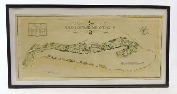
Sold2019Scotland Early Golf MapOld Course St. Andrews Map. Surveyed by A. MacKenize Architect, 1924. McCorquodale & Co., Glasgow, C. 1924. Sight 10 3/4" x 24 1/2".See Sold Price
Sold2022UK & Ireland 19th Cent. Lot of 6 Town & City PlansIncl Dublin, Plymouth, Portsmouth, Glasgow, Edinburgh, and Portrush/Mullaghmore/Galway/Londondenderry/Sligo. Steel Engraved and Lithograph Maps. Examples by Brockhaus, Fullarton/Swanston and BartholomSee Sold Price
Sold2019Keith Johnston Map [Map of Canada]Keith Johnston (cartographer) map of Canada in two sheets, Western Sheet and Eastern Sheet. Title 'Province of Canada'. Circa 1862. Each sheet measures 19.375-in. x 24.5-in. sheet size. Gold-gilt edgeSee Sold Price
Sold2022England & Wales.- Coltman (Nathaniel) Laurie andEngland & Wales.- Coltman (Nathaniel) Laurie and Whittle's New Map of all the Coach Roads both Direct and Cross Engand & Wales with those of Scotland to the South of Edinburgh and Glasgow, engraved maSee Sold Price
Sold2021Fullarton (Pub) 1856 Lot of 4 Antique British MapsIncl Ports and Harbours on the South East Coast of England, Ditto North West Scotland, Ditto South Coast England, and Plymouth Sound. Steel Engraved Map Published 1856-58, by A. Fullarton, London forSee Sold Price
Sold2023THE ROYAL ILLUSTRATED ATLAS OF MODERN GEOGRAPHYTHE ROYAL ILLUSTRATED ATLAS OF MODERN GEOGRAPHYIntroduction by Dr. N. Shaw, Secretary to the Royal Geographical Society, A. Fullarton & Co., London and Edinburgh, circa 1862. Numerous maps. Tooled andSee Sold Price
Sold2020History of the Highland Clans w/color map 1848Heading: (Scotland) Author: Browne, James Title: A History of the Highlands and of the Highland Clans. Place Published: London, Edinburgh and Dublin Publisher:A. Fullarton & Co. Date Published: <See Sold Price
Sold2021Fullarton (Pub) 1856 Mixed Lot of 6 Antique MapsIncl Ports and Harbours on the South East Coast of England, Ditto North West Scotland, Ditto South Coast England, Plymouth Sound, Rome and Environs, and Rio de Janeiro, Steel Engraved Map Published 18See Sold Price
Sold2019Two Maps by Johnson & Ward, consisting of "Ireland andTwo Maps by Johnson & Ward, consisting of "Ireland and Scotland," 1863-1866, hand colored, H.- 8 in., W.- 26 1/2 in.; together with "England and Wales," 1862, hand colored, H.- 26 1/2 in., W.- 18 in.See Sold Price
Sold2021MAP, Western Hemisphere, BlaeuBlaeu's Stunning Carte-a-Figures Map of the Americas in Full Contemporary Color. Western Hemisphere - America. Willem Blaeu, Americae Nova Tabula, 1642 (circa). Hand Color. This stunning carte-a-figurSee Sold Price
Sold2017Hondius: Antique Map of the Western Hemisphere, 1630Title/Content of Map: Western Hemisphere by H Hondius with sea monsters Date Printed: c1630-1634 Cartographer: Henricus Hondius Material/Medium: Paper Size: Approx 17" x 21" Magnificent Map. PublishedSee Sold Price
Sold2023Johnson's family AtlasJohnson's New Illustrated family Atlas with Descriptions Geographical, statistical and Historical, Complied by J H Colton and A J Johnson, Johnson and Browning, New York, 1862. Maps are a tremendous hSee Sold Price
Sold2020Mitchell Map of Western U.S.*** START PRICE IS THE RESERVE *** [America] MITCHELL, Samuel Augustus (1792-1868). A New Map of Texas, Oregon and California with the Regions Adjoining. Engraving with original hand color, with origiSee Sold Price
May 15BonhamsJames Stuart Park (British, 1862-1933) Daffodils canvas 51.5 x 61cm (20 1/4 x 24in); oval sight ...£650
May 09Hunt and Peck Estate Services, Inc.Jacques Nicolas Bellin Map Of Western Part Of New France Or Canada$200(1 bid)
May 09Hunt and Peck Estate Services, Inc.Blaeu LEVINIA VICE COMITATUS Province LENNOX Dumbarton Scotland Map$100
9 hrs LeftJasper521715 Schenk Map of Western Czechia Around Karlovy Vary -- Geographischer Entwurff der Stadt und$220
9 hrs LeftJasper521720 Chatelain Map of Scotland -- Nouvelle Carte d'Ecosse, ou l'on Fait Observer l'Etat de la Nobles$240
May 14Fleischer's AuctionsSherman Family Bible, Extensively Inscribed by General and Mrs. Sherman$2,100(2 bids)
May 16Zikorn Arts & History ObjectsWhite Horse Blended Scotch 1970s Bottle AG No. 66810 (1960s). Size 1 quart, 86.8 proof. White$100
May 16Potter & Potter AuctionsPOLAND, Edwin Christian (1903 – 1991). The Evergreen Playgr...$200
9 hrs LeftJasper52Rand, McNally & Co.'S Map of the Western Hemisphere. Globe Series Compiled from the Latest And Most$340
9 hrs LeftJasper52North America Constructed by W. & A.K. Johnston, Limited. Geographers, Engravers & Printers.$240
9 hrs LeftJasper52New Map of That Portion of North America Exhibiting the United States and Territories...Mexico...$360
May 09Rail & Road Auctions1882 New York, Ontario and Western / New York West Shore and Buffalo Railroad Map$40
May 16Potter & Potter AuctionsSTORM, Mark. Official Texas Brags Map of North America. 194...$200(1 bid)
9 hrs LeftJasper521723 Dampier Map of Voyages to Brazil, Australia and Eat Indies -- Voyage du Cap. Dampier a la N.$280


![Keith Johnston Map [Map of Canada]: Keith Johnston (cartographer) map of Canada in two sheets, Western Sheet and Eastern Sheet. Title 'Province of Canada'. Circa 1862. Each sheet measures 19.375-in. x 24.5-in. sheet size. Gold-gilt edge](https://p1.liveauctioneers.com/5755/147592/74586284_1_x.jpg?height=310&quality=70&version=1565735214)


![Mitchell Map of Western U.S.: *** START PRICE IS THE RESERVE *** [America] MITCHELL, Samuel Augustus (1792-1868). A New Map of Texas, Oregon and California with the Regions Adjoining. Engraving with original hand color, with origi](https://p1.liveauctioneers.com/1968/163248/82424595_1_x.jpg?height=310&quality=70&version=1583340284)


