Sold2024Adirondack Maps (4) [179293]Adirondack Mountains maps (4) from 1902, contained in a nice hardcover jacket. Each map measures 35"x by 27" and each cover different areas. including the northwest, southwest, northeast and southeastSee Sold Price
Sold20221902 Map of Hunterdon County NJ Irving C HicksIrving Hicks Publisher, Pugh & Downing Engineers. Approx 42" x 50 1/2"See Sold Price
Sold20231902 Map of Indian Reservations in the US -- Map Showing Indian Reservations within the Limits ofTitle: 1902 Map of Indian Reservations in the US -- Map Showing Indian Reservations within the Limits of the United States Compiled under the Direction of Hon. W.A Jones Comissioner of Indian AffairsSee Sold Price
Sold2023POLAND LITHUANIA 1569. union Lublin. 15C provinces Gnesna Riga Lviv 1902 mapTITLE/CONTENT OF MAP: 'Poland & Lithuania before the union of Lublin 1569; Inset map of Ecclesiastical provinces of Gnesna, Riga & Lemberg in the XV century' DATE PRINTED: 1902 IMAGE SIZE: Approx 24.5See Sold Price
Sold20201902 Map of LousianaAuthor: Century Title: 1902 Map of Lousiana Medium: Ink on paper Dimensions: 16"x12" Map of Louisiana dated 1902. Published by The Century Company in New York. Double folio map. Key middle right. UppeSee Sold Price
Sold20231902 Map of Vermont Highways, Natural Features, Railroad Stations, etc...This is a large, wall hanging 1902 Complete Map of Vermont Showing Highways and Natural Features, with an Index of All Cities, Villages, Post Offices, and Railroad Stations. Railroad routes are also sSee Sold Price
Sold20211902 Map of FloridaAuthor: Century Title: 1902 Map of Florida Medium: Ink on Paper Dimensions: 11.5"X16.5" Map of Florida dated 1902. Printed for and published by The Century Co. in New York. Double folio. This is the bSee Sold Price
Sold20211902 Map of LouisianaTitle: 1902 Map of Louisiana Author: Century Medium: Ink on Paper Dimensions: 16"X11.5" Description: Map of Louisiana dated 1902. Printed for and published by The Century Co. in New York. Double folioSee Sold Price
Sold20211902 Map of North CarolinaAuthor: Century Title: 1902 Map of North Carolina Materials: Ink on Paper Size/Dimensions: 16"X11.5" Description: Map of North Carolina dated 1902. Printed for and published by The Century Co. in NewSee Sold Price
Sold20211902 Map of GeorgiaAuthor: Century Title: 1902 Map of Georgia Medium: Ink on Paper Dimensions: 11.5"X16.5" Map of Georgia dated 1902. Printed for and published by The Century Co. in New York. Double folio. This is the bSee Sold Price
Sold2023DARK AGES EUROPE. Barbarian Migrations; 451 476 500 AD. 5th century 1902 mapTITLE/CONTENT OF MAP: 'Europe shewing the Barbarian Migrations; Europe 451 A.D.; Europe 476 A.D.; Europe 500 A.D.' DATE PRINTED: 1902 IMAGE SIZE: Approx 25.0 x 32.5cm, 9.75 x 12.75 inches (Large) TYPESee Sold Price
Sold20211902 Map of Washington D.C.Title: 1902 Map of Washington D.C. Medium: Ink on Paper Dimensions: 14.5"X22" Description: Map of Washington D.C. dated 1902. Engraved and published by George Cram in Chicago. Very rare D.C. double foSee Sold Price
Sold20201902 Map of St. LouisAuthor: Cram Title: 1902 Map of St. Louis Medium: Ink on Paper Dimensions: 21.5"X14.5" Map of St. Louis dated 1902. Engraved and published by George Cram in Chicago. Very rare St. Louis double folio mSee Sold Price
Sold2023HOLY ROMAN EMPIRE. Europe. Otto the Great 962. Spread of Christianity 1902 mapTITLE/CONTENT OF MAP: 'Europe at the time of the Restoration of The Empire in the West by Otto the Great 962; Inset map of Spread of Christianity about the year 1000' DATE PRINTED: 1902 IMAGE SIZE: ApSee Sold Price
Sold2024HOLY ROMAN EMPIRE. Europe. Otto the Great 962. Spread of Christianity 1902 mapTITLE/CONTENT OF MAP: 'Europe at the time of the Restoration of The Empire in the West by Otto the Great 962; Inset map of Spread of Christianity about the year 1000' DATE PRINTED: 1902 IMAGE SIZE: ApSee Sold Price
Sold20201902 Map of FloridaAuthor: Century Title: 1902 Map of Florida Medium: Ink on paper Dimensions: 12"X16" Map of Florida dated 1902. Published by The Century Company in New York. Double folio map. Key upper right. Insets oSee Sold Price
Sold20201902 Map of GeogiaAuthor: Century Title: 1902 Map of Geogia Medium: Ink on Paper Dimensions: 11.5"X16" Map of Georgia dated 1902. Published by The Century Company in New York. Key located upper middle. Inset upper righSee Sold Price
Sold20211902 Map of KentuckyTitle: 1902 Map of Kentucky Medium: Ink on Paper Dimensions: 11.5"X16" Description: Map of Kentucky dated 1902. Published by The Century Company in New York. Key located upper right. Inset upper leftSee Sold Price
Sold2024HOLY ROMAN EMPIRE 1519. Europe upon Accession of Emperor Charles V 1902 mapTITLE/CONTENT OF MAP: 'Europe at the Accession of the Emperor Charles V. A.D. 1519' DATE PRINTED: 1902 IMAGE SIZE: Approx 25.5 x 34.5cm, 10 x 13.5 inches (Large) TYPE: Antique colour map. This map wasSee Sold Price
Sold2023Eight Antique Maps of TexasEight Antique Maps of Texas , incl. "Map of the United States and Texas Boundary Line...", 1857-1860 (1902); "Map of a Tour from Independence...by A. Wislizenus, in 1846 and 1847"; "N.W. Corner & Pan-See Sold Price
Sold2016Washington, DC, 1902Original engraving by George Cram, 1902. Map features principal neighborhoods, street divisions, landmarks & other listings. Dimensions: 22” x 14 1/2” No Reserve Buyer pays shipping. This item shiSee Sold Price
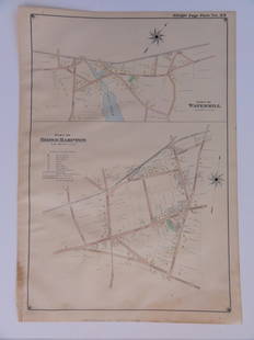
Sold2016Bridgehampton & Watermill, Long Island, 1902Original engraving published by E. Belcher Hyde from "Atlas of Suffolk County, Long Island, New York," Philadelphia, 1902. Map features family names, historic buildings and railroad routes. DimensionsSee Sold Price
Sold2018Antique Map of Chicago, 1902Title/Content of Map: 1902 Map of Chicago -- Sketch Map Showing City Limits of Chicago Date Printed: 1902 Cartographer: Pub. Dudd, Mead & Co. Size: 8.5 X 5.5 in. A nice smaller map of greater ChicagoSee Sold Price
Sold20192V ANNUAL REPORTS OF THE FOREST FISH AND GAME2V ANNUAL REPORTS OF THE FOREST FISH AND GAME COMMISSIONER OF THE STATE OF NEW YORK 1897 1907-1909 Illustrated Chromolithograph Fish Animals Map Adirondack Denton Gillette Maple Syrup This auction lotSee Sold Price
May 14Fleischer's Auctions1755 Map Partie de l'Amerique Septentrionale, qui comprend Le Cours de L'Ohio...$200(3 bids)
2 days LeftTremont AuctionsJohn Speed and Francis Lamb "Map of New England and New York", ca. 1676. Hand colored engraved map$900(3 bids)
2 days LeftTremont Auctions17th century original map 1676 "Virginia and Maryland" by John Speed. 2 sided framing. Overall:$325(2 bids)
2 days LeftCurated Gallery AuctionsHenry Archibald Major (1829 - 1902) Antique English Super Realist 19th Century Still Life Painting$225(6 bids)
May 11Crescent City Auction GalleryWilliam H. Williams (1817-1886), New Orleans "Map of the Sixth District and Carrollton," 1871, H.-$650
4 days LeftJohn Moran Auctioneers, Inc.Arthur Fitzwilliam Tait (1819-1905), Adirondacks with Blue Herons, 1871$2,000
May 12Schilb Antiquarian Rare Books1902 Mark TWAIN 1st ed Double Barrelled Detective Sherlock Holmes RARE$115(6 bids)
May 12Schilb Antiquarian Rare Books1977 JRR Tolkien 1st ed 1st Printing Silmarillion Lord of the Rings + MAP + DJ$200(5 bids)
2 days LeftCurated Gallery AuctionsColette Pope Heldner 1902 -1990 Antique American Impressionist New Orleans Swamp Bayou Oil Painting$160(3 bids)
May 18Rich Penn AuctionsVictorian English Silver Cased Carriage Clock, William Comyns-London, 1902 w/repousse Raphaelite$125(2 bids)
263 Lots AwayMerrill's Auctioneers and Appraisers1902 Point Judith Country Club Sterling Polo Cup$100(1 bid)
6 days LeftHunt and Peck Estate Services, Inc.Jacques Nicolas Bellin Map Of Western Part Of New France Or Canada$200(1 bid)


![Adirondack Maps (4) [179293]: Adirondack Mountains maps (4) from 1902, contained in a nice hardcover jacket. Each map measures 35"x by 27" and each cover different areas. including the northwest, southwest, northeast and southeast](https://p1.liveauctioneers.com/2699/324080/174413226_1_x.jpg?height=310&quality=70&version=1711485545)