Sold2018Ca 1860 Cruchley Tourist Map of EuropeCa 1860 Cruchley Tourist Map of Europe-- Dimensions: ---See Sold Price
Sold20181856 Cruchley Map of Europe with Early Railroads ShownTitle/Content of Map: 1856 Cruchley Map of Europe with Early Railroads Shown -- A New Map of Europe Exhibiting its Natural & Political Divisions Drawn from the Most Recent Authorities Improved to theSee Sold Price
Sold2019Beautiful 1860 map of EuropeMap of Europe Showing its Political Divisions. Clean with good original hand color. 1860 date; from Mitchell’s 1862 atlas. Hint of toning at three edges. 10.75 x 13.375. Reserve: $40.00 Shipping: DoSee Sold Price
Sold2018Antique Tourist Map Carmel, CA c1930sAntique Tourist map of Carmel-By-The-Sea, CA c1930s. Has crease marks. Excellent condition. 28"h x 21"w. Frame 29.5"h x 22.5"w. Spend $5000 or more at this auction and all of your SHIPPING IS FREE wiSee Sold Price
Sold2016Set of 9 Victorian Scottish Carpet Balls, ca. 1860Europe, Scotland, ca. 1860 CE. A group of nine ceramic balls decorated in various attractive patterns used in a 19th century Victorian parlor game called Carpet Ball, an indoor ball game played on carSee Sold Price
Sold2016Lot of 9 Victorian Scottish Ceramic Carpet BallsEurope, Scotland, ca. 1860 CE. This ensemble of nine ceramic balls decorated in various attractive patterns intrigued me from moment one. After a bit of research, it became clear that these were usedSee Sold Price
Sold2017Mitchell: Political Map of Europe, 1860Map of Europe, Showing Its Gt. Political Divisions. S. Aug. Mitchell, Williams, W. 1865. Roses floral border. Top margin stained. Quarto – 10.60 H x 13.30 W Inches Please note that this lot has a coSee Sold Price
Sold2023Rapkin, John 1860 Pair of Maps. Turkey in Europe and Asia MinorSteel Engraved Map Published 1860 by The London Printing & Published Company, London for "The Royal Dictionary-Cyclopedia for Universal Reference" by Thomas Wright. Drawn & Engraved by John Rapkin. FoSee Sold Price
Sold2022Sabena Belgian World Airlines. Brussels: Marci, ca. 1966. R...Sabena Belgian World Airlines. Brussels: Marci, ca. 1966. Route map poster of Europe, Africa, and the Middle East labeled with Sabena’s routes as well as seasonal routes and connecting carriers.See Sold Price
Sold201519th C. English Dome Ear Trumpet, ex-HistoriaEurope, England, London, ca. 1860 CE. An ear version of the hearing aid, this ear horn or dome ear trumpet was dubbed as such, because of its resemblance to the shape of the dome on St. Paul's CathedrSee Sold Price
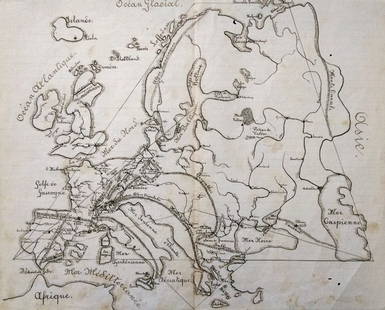
Sold2017FRENCH SCHOOL, 19th centuryDescription : "Map of Europe" ca 1890.-- Medium : Sepia on paper.-- Dimensions : 35 x 45 cmSee Sold Price
Sold202119th Century Map of Edo (Tokyo)Large map of Edo (Tokyo), ca. 1860. Dimensions: 114X93 cm. Good-fair condition (slight tears to folding lines, one panel detached). Provenance: Prof. Avraham Altman collection.Our sincere thanks to liSee Sold Price
Sold2017Jefferys: Antique Map of Europe, 1763Map: Europe. Publication Date: 1763 ca. Authors: JEFFERYS, T. Size: Octavo – 7.10 H x 8.80 W Inches T. Jefferys, Sc. On polar projection Thomas Jefferys (1719-1771) was the Royal Cartographer tSee Sold Price
Sold2020Rapkin, John 1860 Lot of 6 European MapsIncl Greece, Turkey in Europe, Switzerland, Spain/Portugal, Sweden/Norway, and Russia in Europe. Steel Engraved Map Published 1860 by The London Printing & Published Company, London for "The Royal DicSee Sold Price
Sold2024TURKEY IN EUROPE. Constantinople/Istanbul view. Balkans. TALLIS/RAPKIN 1860 mapTITLE/CONTENT OF MAP: 'Turkey in Europe' DATE PRINTED: 1860 IMAGE SIZE: Approx 27.0 x 36.0cm, 10.75 x 14 inches (Large); Please note that this is a folding map. TYPE: Antique steel engraved map with oSee Sold Price
Sold2022GERBIG, Richard. Fly KLM / The Skier’s Airline to Europe. [...GERBIG, Richard. Fly KLM / The Skier’s Airline to Europe. [Bern]: Swiss National Tourist Office, ca. 1960s. The Swiss flag flies over a group of skiers racing across snow-covered slopes. 40 x 25See Sold Price
Sold2020[SEUTTER, M] 52 Maps of Europe sold togetherSEUTTER,M. 52 Maps of Europe sold together. ca. 1700. Includes. Europa ** Flandria ** Hanoniae ** Belgii **Luxemburg ** Dauphine Five Delpinatus ** Parmensis Et Placentinus ** Transylvaniae ** DucatusSee Sold Price
Sold201819th C Map Oregon, Washington, Idaho, & Part of Montana**Originally Listed At $100** Samuel Augustus Mitchell Jr. (American), "Map of Oregon, Washington, Idaho and Part of Montana." ca. 1860. A fabulous example of S. A. Mitchell Junior's 1866 map of WashiSee Sold Price
Sold2024Central Europe with Railways: operating & under construction. SWANSTON 1860 mapCAPTION PRINTED BELOW PICTURE: 'Central Europe with Railways' DATE PRINTED: 1860 IMAGE SIZE: Approx 44.5 x 55.0cm, 17.5 x 21.75 inches (Large); Please note that this is a folding map. TYPE: Antique atSee Sold Price
Sold2019Ca 1860's Italy Keith Johnston Maps (2)Two Ca 1860's 'North and Central Italy and the Island of Corsica' and 'South Italy and the Island of Sardinia' Keith Johnston Maps. By Keith Johnston, F.R.S.E. Keith Johnston's General Atlas Engraved,See Sold Price
Sold2021TWO BOOKS ON ILLUMINATING BY WYATT AND TYMMS."The Art of Illuminating as Practised in Europe from the Earliest Time" by Tymms and Wyatt. Published in London by Day and Son, ca. 1860. With multiple color illustrations. And "The History, Theory anSee Sold Price
Sold2018TURKEY IN EUROPE: Constantinople (Istanbul) vignette.TITLE/CONTENT OF MAP: 'Turkey in Europe' Date: 1860 IMAGE SIZE: Approx 27.0 x 33.5cm, 10.5 x 13.25 inches (Large); Please note that this is a folding map. TYPE: Antique steel engraved map with originaSee Sold Price
Sold2018Rand McNally: Antique Map of Europe, 1898Title/Content of Map: Europe Rand, McNally & Co.'S Indexed Atlas of the World Map of Europe. Date Printed: 1898 ca. Cartographer: RAND, MCNALLY & CO. Publisher: RAND, MCNALLY & COMPANY 1898 ca. CHICAGSee Sold Price
Sold2018Weller: Antique Map of Europe, 1877Title/Content of Map: Europe (Latter Part of the 10th Century.) Date Printed: 1877 ca. Cartographer: WELLER, EDW. Publisher: G.P. PUTNAM'S SONS 1877 ca. NEW YORK Size: Quarto – 6.00 H x 8.75 W IncheSee Sold Price
May 16Potter & Potter AuctionsGEESINK, Joop (1913 – 1984). Europa. 1957. Netherlands: KLM...$100
May 16DuMouchellesFrench Second Empire Upholstered Mahogany Benches, Ormolu Mounts, Ca. 1860, H 27" W 25.5" Depth$375
May 16DuMouchellesJohann Kaendler (German, 18th C.) for Meissen (German) Porcelain Figural Grouping, Allegory of$300(1 bid)
May 16DuMouchellesMeissen (German) & Ernst Teichert (Meissen, Germany) Blue Onion Porcelain Serving Dishes, Ca.$300
May 16DuMouchellesMeissen (German) & Ernst Teichert (Meissen, Germany) Blue Onion Porcelain Teacups, Plates & Egg$450
May 29Carlo Bonte AuctionsA large Japanese woodblock print by Kitao Masanobu (1761-1816) and a triptych by Kunisada€200
May 19HELIOS AUCTIONSA SET COMPRISED OF A MILK GLASS BEAKER WITH A RED-BROWN LITHYALIN GLASS VASE, CA. 19TH C.$100
1 day LeftTremont AuctionsJohn Speed and Francis Lamb "Map of New England and New York", ca. 1676. Hand colored engraved map$900(3 bids)


![GERBIG, Richard. Fly KLM / The Skier’s Airline to Europe. [...: GERBIG, Richard. Fly KLM / The Skier’s Airline to Europe. [Bern]: Swiss National Tourist Office, ca. 1960s. The Swiss flag flies over a group of skiers racing across snow-covered slopes. 40 x 25](https://p1.liveauctioneers.com/928/255324/132836124_1_x.jpg?height=310&quality=70&version=1658268357)
![[SEUTTER, M] 52 Maps of Europe sold together: SEUTTER,M. 52 Maps of Europe sold together. ca. 1700. Includes. Europa ** Flandria ** Hanoniae ** Belgii **Luxemburg ** Dauphine Five Delpinatus ** Parmensis Et Placentinus ** Transylvaniae ** Ducatus](https://p1.liveauctioneers.com/1124/187577/94368891_1_x.jpg?height=310&quality=70&version=1607095126)


![[POTTERY]. Pair of Rare Illustrated Jugs Plus a Rare Illust... (1 of 1)](https://p1.liveauctioneers.com/928/328184/176813309_1_x.jpg?height=282&quality=70&version=1714496988)


![[LEUTZE, Emauel (1816-1868), artist]. Grant at the Capture ... (1 of 1)](https://p1.liveauctioneers.com/928/328184/176813677_1_x.jpg?height=282&quality=70&version=1714496988)


