Sold2019* SAXTON, Christopher (ca 1540-ca 1610), and William* SAXTON, Christopher (ca 1540-ca 1610), and William KIP (fl.1598-1610). Flint Comitatus quem ordovices olim Incoluerunt. [London, 1607]. Hand-colored engraved map of Flint, image 265 x 320 mm (320 xSee Sold Price
Sold2019Framed Map of Yorkshire, EnglandEast Riding Division, home of Thomas Tenney before migrating to New England. Map makers: Christopher Saxton, Surveyor and Cartographer; William Kip, Engraver and Printer. [Map: 7 x 9 inches; Frame: 14See Sold Price
Sold2016William Kip after Christopher Saxton mapWilliam Kip after Christopher Saxton map- ''Montgomery''- etching with hand-coloring, 1637, some soft creases in paper. 10 1/2 x 12 1/2''See Sold Price
Sold2024William Kip / Christopher Saxton Huntingdon Comitatus qui pars fuir IcenorumChristopher Saxton's map of Huntingdon, from the 1637 edition of Camden's BritanniaSee Sold Price
Sold2020Norden, John - William Kip Sussexia sive Southsex, olimc.1670, 30.5 x 40cm, Latin text to verso, some slight marginal worming, tape stain along left edge; [Idem] - Saxton, Christopher Norfolciae comitatus quem oliceni... c.1637, 33.5 x 39cm, verso blank,See Sold Price
Sold20152 County Maps incl: LINCOLNIAE.[Britain] 2 Maps. ++ LINCOLNIAE Comitatus ubi olim insederunt Coritani. In lower portion of scale: “Christophorus Saxton descript: William Kip Sculp.” [Ca. early 1600’s.] Map number “26.” atSee Sold Price
Sold2018Christopher Saxton 1607 Map of ShropshireChristopher Saxton & William Hole 1607 hand colored map of Shropshire from Camden's Brittanica titled "Salopiae Comitatus quen Cornauii", sight view 11 1/4" x 14'See Sold Price
Sold2021Two Early Engraved Maps: Ireland & GloucestershireA pairing of early hand-colored engraved maps to include a Christopher Saxon and William Hole map of "Glocestriae Comitatus Olim Sedes Dobuncrum", and a William Hole map of Ireland titled "Hiberniae".See Sold Price
Sold20201610 H/C Engraved Map of Worcestershire, SaxtonBeautiful 1610 Hand-colored Copperplate Engraving of Map of Worcestershire by Cartographer Christopher Saxton Entitled Wigorniensis Comitatus Sabrinae | Engraved map by William Hole | From Camden's BrSee Sold Price
Sold2023Antique Maps of Hertfordshire (2)Hertfordshire by Robert Morden. London, Early 18th C. With Hertfordiae Comitatus a cattifuclanis olim inhabitatus (Hertfordshire) by John Norden, engraved by William Kip, c. 1637. Largest 16" x 18 1/2See Sold Price
Sold20221st Edition 1607 Wiltshire May by Kip & SaxtonWiltoniae Comiatus herbida Planicic nobilis vulgo willshire pars olim Belgarvm. From William Camden's great Renaissance work 'Britannia' which was originally published in Latin, in 1586 with only a geSee Sold Price
Sold2024After Christopher Saxton, Map of Cornwell(1542-1606) 1576, colored print by Taylowe, Limited, 1970, British Museum Maps. Sight: 18-1/2"h x 21-1/2"w Overall: 21-1/2"h x 24-1/2"wSee Sold Price
Sold202217th c. Christopher Saxton Map of Cambridgeshire17th c. Christopher Saxton map of Cambridgeshire based on the first survey of England by Christopher Saxton and published in Camden's Britannia (London:1607-1637), original copper plate engraving withSee Sold Price
Sold2024SAXTON'S MAP OF ESSEX ENGLAND 1576 MUSEUM EDITIONChristopher Saxton 1540-1610 Map of Essex 1576 England . British Museum Maps C.7 C.I. notation. Detailed and Colored. Exact print date unknown. 20.50" x 25" FramedSee Sold Price
Sold2022Scotland.- Hole (William) Scotia Regnum, [c. 1610]; together with Quad's Scotia Tabula, and 10 otherScotland.- Hole (William) and Christopher Saxton. Scotia Regnum, from Camden's Britannia, engraving, 270 x 320 mm (10 5/8 x 12 1/2 in), minor browning and surface dirt, unframed, [circa 1610]; togetheSee Sold Price
Sold2017WILLIAM KIP AFTER JOHN NORDEN HAND COLORED MAPWILLIAM KIP AFTER JOHN NORDEN, HAND COLORED MAP, H 11", W 14 7/8", "CANTIUM QUOD NUNC KENT":Parts of Essex and Parts of Middlesex, London. Hand colored. Retailed by H. S. Ward, 2 Parkside, Sussex. FraSee Sold Price
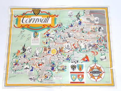
Sold2021A British Railways lithographic poster, Cornwall,A British Railways lithographic poster, Cornwall, Depicting an illustrative map of Cornwall designed by William Bowyer (1926-2015). Printed by Jordison & Co. Ltd. London and Middlesbrough. Approx. 39See Sold Price
Sold2021Antique 17th C. Norfolk England Map EngravingAntique 17th C. Norfolk, England Map Hand Colored Engraving. Described by Christopher Saxton. Augmented by I. Speede. Measures 16 inches high x 21.5 inches wide.See Sold Price
Sold2015Willem Blaeu, Cornubia sive Cornwallia, Amsterdam:Willem Blaeu, Cornubia sive Cornwallia, Amsterdam: c.1640, Handcolored engraved map of Cornwall, coats-of-arms, galleons, foxing, and water staining, center creaseSee Sold Price
Sold2022Voyages.- Irving (Washington) A History of the Life and Voyages of Christopher Columbus, 4 vol.,Voyages.- Irving (Washington) A History of the Life and Voyages of Christopher Columbus, 4 vol., first English edition, half-titles, 2 engraved folding maps, armorial bookplate of Sir William Eden toSee Sold Price
Sold2022Cornwall.- Borlase (William) Antiquities, historical and monumental, of the county of Cornwall,Cornwall.- Borlase (William) Antiquities, historical and monumental, of the county of Cornwall, second edition, 2 engraved maps, of which 1 folding, 25 engraved plates, of which 1 folding, damp-stainiSee Sold Price
Sold2022Yorkshire.- Greenwood (Christopher) Map of the County of York, made on the Basis of Triangles in theNO RESERVE Yorkshire.- Greenwood (Christopher) Map of the County of York, made on the Basis of Triangles in the County, determined by Lieut. Col. Wm. Mudge, county map in six sections, with calligraphSee Sold Price
Sold2019Williams Map of America (1833)WILLIAMS, C.S. (Fl. 1830-1846). Traveler's Directory and Statistical view of the United States and Map of the U.S. Engraved folding map in original gilt red boards. New Haven, 1833. 5 1"8" x 3 1/8" coSee Sold Price
Sold2023Early C.S. Williams Map Of Texas1845, Map Of Texas From The Most Recent Authorities, Hand Colored Engraving, Sight 12 X 15 Inches, Matted And Burl Frame 22 X 25 X 0.5 Inches, Slight Toning To Paper Appropriate For Age, Not ExaminedSee Sold Price
Jun 07Austin Auction Gallery(2) CHRISTOPHER SPITZMILLER PORCELAIN 'WILLIAM' TABLE LAMPS$2,000(2 bids)
3 days LeftForum AuctionsSt. Helena.- Beatson (Maj.-Gen. Alexander) Tracts Relative to the Island of St. Helena, 1816£400
2 days LeftJasper521723 Dampier Map of Voyages to Brazil, Australia and Eat Indies -- Voyage du Cap. Dampier a la N.$280
Jun 08Early American History Auctions1720 Colonial Northumberland County Virginia Manuscript Deed and Map Plot$400
4 days LeftFreeman's | Hindman[CIVIL WAR]. Small archive associated with Lt. Col. William M. Vogelson (1831-1892), 27th Ohio$250
Jun 23Schilb Antiquarian Rare Books1848 Emory Military Reconnaissance 1ed California MAP Indians Texas New Mexico$2(2 bids)
Jun 07Freeman's | Hindman[MAP]. ORTELIUS, Abraham. Peregrinationis Divi Pauli Typus Corographicus. 1592.$150(1 bid)
Jun 14DuMouchellesWilliam H. Gamble (American, B. 1863) Hand Colored Engraving, Ca. 1863, "County Map of Michigan And$50(1 bid)
Jun 06Freeman's | HindmanFAULKNER, William (1897-1962). Absalom, Absalom! New York: Random House, 1936.$300
2 days LeftAdam's AuctioneersWilliam Crozier (1930-2011) Untitled Oil on board, 91 x 71.5cm (35¾ x 28'') Signed William€5,000
Featured2 days LeftJasper521750 Bowen Map of Bermuda and St. Kitts -- A New & Accurate Map of Bermudas or Sommer's Islands...$600


![* SAXTON, Christopher (ca 1540-ca 1610), and William: * SAXTON, Christopher (ca 1540-ca 1610), and William KIP (fl.1598-1610). Flint Comitatus quem ordovices olim Incoluerunt. [London, 1607]. Hand-colored engraved map of Flint, image 265 x 320 mm (320 x](https://p1.liveauctioneers.com/197/138502/70223744_1_x.jpg?height=310&quality=70&version=1553021483)


![Norden, John - William Kip Sussexia sive Southsex, olim: c.1670, 30.5 x 40cm, Latin text to verso, some slight marginal worming, tape stain along left edge; [Idem] - Saxton, Christopher Norfolciae comitatus quem oliceni... c.1637, 33.5 x 39cm, verso blank,](https://p1.liveauctioneers.com/94/169912/85619991_1_x.jpg?height=310&quality=70&version=1590766753)
![2 County Maps incl: LINCOLNIAE.: [Britain] 2 Maps. ++ LINCOLNIAE Comitatus ubi olim insederunt Coritani. In lower portion of scale: “Christophorus Saxton descript: William Kip Sculp.” [Ca. early 1600’s.] Map number “26.” at](https://p1.liveauctioneers.com/179/82189/42599742_1_x.jpg?height=310&quality=70&version=1447864785)


![Scotland.- Hole (William) Scotia Regnum, [c. 1610]; together with Quad's Scotia Tabula, and 10 other: Scotland.- Hole (William) and Christopher Saxton. Scotia Regnum, from Camden's Britannia, engraving, 270 x 320 mm (10 5/8 x 12 1/2 in), minor browning and surface dirt, unframed, [circa 1610]; togethe](https://p1.liveauctioneers.com/5458/260724/135800559_1_x.jpg?height=310&quality=70&version=1662479034)


![[MAP]. ORTELIUS, Abraham. Turcici Imperii Descriptio.1592. (1 of 2)](https://p1.liveauctioneers.com/197/329395/177650538_1_x.jpg?height=282&quality=70&version=1715364962)
![[CIVIL WAR]. Small archive associated with Lt. Col. William M. Vogelson (1831-1892), 27th Ohio (1 of 10)](https://p1.liveauctioneers.com/197/329785/177758363_1_x.jpg?height=282&quality=70&version=1715625218)

![[MAP]. ORTELIUS, Abraham. Peregrinationis Divi Pauli Typus Corographicus. 1592. (1 of 2)](https://p1.liveauctioneers.com/197/329395/177650535_1_x.jpg?height=282&quality=70&version=1715364962)
![Milne (A.A.) [The Christopher Robin books], first editions, 1924-28. (1 of 1)](https://p1.liveauctioneers.com/5458/329231/177515073_1_x.jpg?height=282&quality=70&version=1715269091)


