Sold2024CHEN JUZHONG TATAR HUNTING MAP HAND SCROLLMeasurements: Height: 27.5 cm, Width: 330 cm Chen Juzhong Tatar hunting map hand scrollSee Sold Price
Sold2021Chinese Landscape Painting Silk Hand Scroll, Guo XiChinese Landscape Painting Silk Hand Scroll, Guo Xi Mark Width:390cm, Height:28.5cm,See Sold Price
Sold2019OGILBY, John (1600-1676). The Road from CambridgOGILBY, John (1600-1676). The Road from Cambridg to Coventry. [London, ca 1570s]. Engraved scroll map hand-colored in wash and outline, visible area 17 1/4 x 14 1/14 in. (444 x 360 mm). DecoSee Sold Price
Sold2019GUO YICONG CHINESE HAND PAINTED SCROLLGuo Yicong (Chinese, b.1940) A Chinese hand painted scroll depicting bamboo and bird of paradise. Wd: 95" Dpth: 18.5"See Sold Price
Sold2019GUO YICONG CHINESE HAND PAINTED SCROLLGuo Yicong (Chinese, b.1940) A chinese hand painted scroll depicting plum blossoms. Sight size: 27" x 18" Ht: 66" Wd: 24"See Sold Price
Sold2023Attributed to Guo Xi, Ink on Silk, Hand ScrollAttributed to Guo Xi, Ink on Silk, Hand Scroll. L.370cm, W33cm,See Sold Price
Sold2022GUO XI, CHINESE TRAVELING PAINTING SILK HAND SCROLLDimension: 13.4 x 393.7 inches, 34 x 1000cm.See Sold Price
Sold2022GUO XI, Chinese Landscape Painting Silk Hand ScrollGUO XI, Chinese Landscape Painting Silk Hand Scroll Length:30cm, Width:202cm, Detailed condition reports are not included in this catalog. For additional information, including condition reports, pleaSee Sold Price
Sold2023C. 1779, ANTARCTICA & CAPTAIN COOK'S TRAVELS MAPAntonio Zatta (Italian fl. 1775-1797), "Emisfero Terrestre Meridionale Tagliato su l'Equatore", circa 1779, hand colored etching on paper depicting map of Antarctica and Captain Cook's travels, unframSee Sold Price
Sold2024ANTIQUE TRAVEL GUIDE MAP OF JAPANAntique (1843 - 1865) Woodblock Travel Guide Map of Japan. The vibrantly colored map was created in three stages: Tempo (1843), Ansei (1857), Keio (1865). The map is set on a scroll and accompanied bySee Sold Price
Sold2019Travels In N. America In1827-28, hand colored map, 1830Title: Travels In North America, In The Years 1827 And 1828 Provenance: IN THREE VOLUMES, 1830, with large hand colored folding map of United States and Canada showing Capt. Hall's route. [HOWES H 47]See Sold Price
Sold2023Hand Painted & Japanese Railway Map FansHand painted Japanese folding fans (2) on metallic paper, wood handles and ribs. Japanese folding fan, hand painted scene on one side, travel route/railway map on reverse, wood handle and ribs. Hand pSee Sold Price
Sold2022Early Hand Colored Maps Depicting the AmericasOne by Pieter Vander, circa 1707, the Magellan period. This map was used to illustrate the Dutch translations of the travel account of Diego Lopez de Sequeira. The second map, pulled from a book on laSee Sold Price
Sold2021Pallas, Peter 1802 Hand Col Map. Madshary, GeorgiaHand Colored Copper Engraved Map Published 1802-03, London for "Travels through the Southern Provinces of the Russian Empire In the Years 1793 and 1794" by Peter Pallas. Paper Size: 11 x 8.5 inch (28See Sold Price
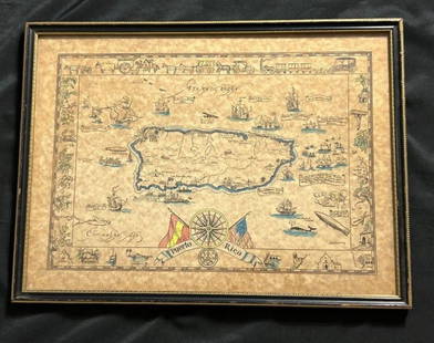
Sold2023Vintage Hand -Colored Pictorial Map of Puerto Rico Circa 1931 by E.B.K. DooleyA vintage hand-colored map of Puerto Rico by E.B.K. Dooley, published c. 1931. This map has a decorative border filled with local plants, wildlife, buildings and transportation. In small scrolls, therSee Sold Price
Sold2016Canaan, Travels of Jesus from the Bible Atlas 1836Map: Canaan, Travels of Jesus Christ from the Bible Atlas Maker: Richard Palmer Map Origin: New York Date: 1836 Medium: Hand colored lithograph Size: 8.25 x 8.25 inches Please note that this lot has aSee Sold Price
Sold2024Rare Hand-coloured Map - Florida - Louisiana - United States - BellinIts finely engraved, hand-coloring engraved map from the Dutch edition of acques Nicolas Bellin "Histoire General of Travel". Published in Amsterdam, 1770 year. Carte de la Floride de la LouSee Sold Price
Sold2024Rare Antique Map - Hudson Bay Chart - Old Map of North America - Bellin - Jacques"Carte de la Baye de Hudson". Its finely engraved, hand-coloring engraved map from the Dutch edition of acques Nicolas Bellin Histoire "General of Travel". Published in Amsterdam. A handsome chart ofSee Sold Price
Sold2022(HUNGARY.) Robert Townson. Travels in Hungary, with a Short Account of Vienna in the Year 1793.(HUNGARY.) Robert Townson. Travels in Hungary, with a Short Account of Vienna in the Year 1793. xviii, [2], 506 pages, hand-colored engraved folding map, engraved folding table, and 16 engraved platesSee Sold Price
May 16Himalayan Auction HouseA hand scroll with a Chinese oil painting of a lotus pond, by Wu Guanzhong$1,800(5 bids)
May 14Fleischer's Auctions1755 Map Partie de l'Amerique Septentrionale, qui comprend Le Cours de L'Ohio...$200(3 bids)
May 11Cape Ann Auction19th Century Hand Painted Chinese Scroll Depicting a Pilgrimage in a Mountainous Landscape$500


![OGILBY, John (1600-1676). The Road from Cambridg: OGILBY, John (1600-1676). The Road from Cambridg to Coventry. [London, ca 1570s]. Engraved scroll map hand-colored in wash and outline, visible area 17 1/4 x 14 1/14 in. (444 x 360 mm). Deco](https://p1.liveauctioneers.com/197/151909/76680351_1_x.jpg?height=310&quality=70&version=1570472488)


![Travels In N. America In1827-28, hand colored map, 1830: Title: Travels In North America, In The Years 1827 And 1828 Provenance: IN THREE VOLUMES, 1830, with large hand colored folding map of United States and Canada showing Capt. Hall's route. [HOWES H 47]](https://p1.liveauctioneers.com/5584/144949/73283335_1_x.jpg?height=310&quality=70&version=1561753751)


![(HUNGARY.) Robert Townson. Travels in Hungary, with a Short Account of Vienna in the Year 1793.: (HUNGARY.) Robert Townson. Travels in Hungary, with a Short Account of Vienna in the Year 1793. xviii, [2], 506 pages, hand-colored engraved folding map, engraved folding table, and 16 engraved plates](https://p1.liveauctioneers.com/199/251723/130782470_1_x.jpg?height=310&quality=70&version=1655133895)


