Sold2017Mallet: Antique Map of South Asia, 1683Inde' The map encompasses the whole of India & Indochina including Burma, Thailand, Malaysia/Singapore and South East Asia. The Maldive islands are shown. The map shows the mythical Lake Chiamay, theSee Sold Price
Sold2018ANCIENT INDOCHINA. 'Inde Ancienne a l'Orient du Gange'Reserve Reduced! TITLE OF THE MAP: 'Inde Ancienne a l'Orient du Gange' ancient India from the Ganges eastwards. The map shows the mythical Lake Chiamay, the supposed source of the 5 great river systemSee Sold Price
Sold2018ANCIENT INDOCHINA. 'Inde Ancienne a l'Orient du Gange'TITLE OF THE MAP: 'Inde Ancienne a l'Orient du Gange' ancient India from the Ganges eastwards. The map shows the mythical Lake Chiamay, the supposed source of the 5 great river systems of Southeast AsSee Sold Price
Sold20211683 Sanson Map Great Lakes to Newfoundland -- LeTitle: 1683 Sanson Map Great Lakes to Newfoundland -- Le Canada, ou Nouvelle France, &c. Tiree de diverses Relations des Francois, Anglois, Hollandois, &c. Cartographer: N Sanson Year / Place: 1683 c.See Sold Price
Sold20151867 Map of California and NevadaLeander Ransom & Amos Doolittle: A New Map of the States of California and Nevada, Exhibiting the Rivers, Lakes, Bays and Islands, with the principal Towns, Roads, Railroads and Transit Routes to theSee Sold Price
Sold20181683 Sanson Map of the Great Lakes and the Upper EastTitle/Content of Map: 1683 Sanson Map of the Great Lakes and the Upper East Coast -- Le Canada, ou Nouvelle France, &c. Tiree de diverses Relations des Francois, Anglois, Hollandois, &c. Date: 1683, PSee Sold Price
Sold20181683 Sanson Map of the Great Lakes and the Upper EastTitle/Content of Map: 1683 Sanson Map of the Great Lakes and the Upper East Coast -- Le Canada, ou Nouvelle France, &c. Tiree de diverses Relations des Francois, Anglois, Hollandois, &c. Date Printed:See Sold Price
Sold2022[MANUSCRIPT MAP-FLORIDA & MISSISSIPPI RIVER] Map Showing Raiford's Proposed Artificial River and[MANUSCRIPT MAP-FLORIDA & MISSISSIPPI RIVER] Map Showing Raiford's Proposed Artificial River and Plan to Continue the Western and Southern Inland System of Navigation to Harbors in the Atlantic. [FernSee Sold Price
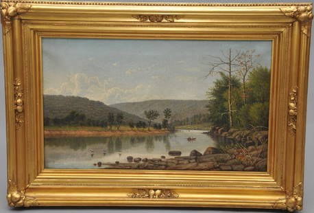
Sold2017William Guy Wall. "Rowers on the Lake". River landscapeWilliam Guy Wall. "Rowers on the Lake". River landscape with figures in a boat. Oil on canvas in original gilt Hudson River style frame. S.L.R. Sight size: 15" x 25". Overall size: 23" x 32".See Sold Price
Sold2023Paul Weber 1852, Fine Quality 19th C. HUDSON RIVER VALLEY AUTUMN LAKE LANDSCAPEPaul Weber 1852, Fine Quality 19th C. HUDSON RIVER VALLEY AUTUMN LAKE LANDSCAPE. Signed on front and signed on back, Philadelphia Label on Verso. Framed. size: 20.25 x 25, 23.5 x 28.5 outside frameSee Sold Price
Sold2016Map, Hudson River, Rev. War, Sauthier, 1776At the top of the map is written: "A Topographical Map of Hudsons River, with the Channels Depth of Water, Rocks, Shoals, &c. and the Country Adjacent, from Sandy-Hook, New York and Bay to Fort EdwardSee Sold Price
Sold2023DING ERZHONG: CRYSTAL INSIDE PAINTED 'LANDSCAPE AND ROCK' SNUFF BOTTLEChinese. Painted on one main side with an idyllic landscape scene with country residences beneath large trees beside a lake or river with two sailing boats beneath more distant peaks, inscribed in scrSee Sold Price
Sold2022James Suydam Major Luminous Hudson River Artist Sunset River LandscapeJames Augustus Suydam (1819 - 1865) An original oil by one of the rarest of the Hudson River School artist! Depicting a luminous sunset lake or river scene with boaters. Initialed lower left and alsoSee Sold Price
Sold2024Anna Pottery Railroad and River Guide FlaskAmerican Second Half 19th Century. Pig Shaped with river and railroad map and inscribed "With a little good old rye in hogs.."See Sold Price
Sold2015Large Daum Nancy Cameo Landscape GlassFrance, early 20th century, tall waisted form flaring slightly at top and bottom, enameled cameo lake or river sunset landscape against a yellow sky, signed in cameo "DAUM/NANCY" with cross of LorrainSee Sold Price
Sold2023IIMPORTANT 18TH C. REVOLUTIONARY WAR PERIOD MAP: SURVEY OF LAKE CHAMPLAIN, 1776IMPORTANT 18TH C. REVOLUTIONARY WAR PERIOD MAP: SURVEY OF LAKE CHAMPLAIN, 1776, SURVEY OF LAKE CHAMPLAIN INCLUDING LAKE GEORGE , CROWN POINT, AND ST. JOHN. SURVEYED, BY ORDER OF HIS EXCELLENCY MAJOR-GSee Sold Price
Sold2023Regis Francois Gignoux 1816-1882 Sunset Lake Signed Hudson River School Oil PaintingAntique American Hudson River School landscape painting by Regis Francois Gignoux (1816 - 1882). Oil on canvas. Framed. Signed lower right. Image size, 12L x 18H. Cleaned by Yost Conservation, LLC.See Sold Price
Sold2024Map of Great Lakes, c1850's [180162]Antique map of the Great Lakes, Ohio, Indiana, Illinois, Wisconsin, and Michigan. Colored legend indicating Townships ranges. Inset of the World Hemispheres divided by western and eastern. C 1850's, FSee Sold Price
Sold2024De Fer Map of the Mississippi RiverDE FER, Nicolas (1646-1720). Partie Meridionale de la Riviere de Missipi, et ses environs, dans l'Amerique Septentrionale. Mis au jour par N. de Fer. Geographe de sa Majeste Catolique 1718. Engraved mSee Sold Price
Sold2023Original Vintage Indochine Francaise Map by Lucien Boucher 1935 Vietnam Laos CambodiaAs one can only imagine, travel in the Far East in the 1920's must have been a challenging adventure. This well illustrated map poster by master artist, Lucien Boucher shows the various routes once coSee Sold Price
Sold2023Lemuel Wiles 1826-1905 Signed Hudson River School Framed Oil Painting Silver Lake NYUp for sale here is one of two really nice oil paintings by Lemuel Maynard Wiles (1826 - 1905). The paintings are scenes of Silver Lake, NY. Finely painted and nicely framed. Signed. Image size, 11.5LSee Sold Price
Sold2022(MISSISSIPPI RIVER.) John Ross. Course of the River Mississipi, From the Balise to Fort Chartres.(MISSISSIPPI RIVER.) John Ross. Course of the River Mississipi, From the Balise to Fort Chartres. Engraved folding map of the lower Mississippi River on two sheets joined. 44¾x15 inches sheet sizSee Sold Price
Sold2024Nevada Pyramid Lake Indians Books (7) [181684]1. 1985 Sand in a Whirlwind by Egan, signed by Wheeler as foreword 2. 1984 As Long as the River Shall Run. 3. 1977 Pyramid Lake by Cerveri. 4. 1973 Paiutes of Pyramid Lake by Herman and signed by authSee Sold Price
Sold2022H.M.S. AJAX CAPTAIN'S MAP OF THE BATTLE OF THE RIVER PLATEOriginal map depicting the Battle of the River Plate, 37 x 29 in. coated linen map fabric, prepared by Capt. Douglas H. Everett, commander of the H.M.S. AJAX only days after the December 13, 1939 engaSee Sold Price
4 days LeftJasper521872 Mitchell Map of Massachussetts, Connecticut and Rhode Island -- County Map of Massachussetts,$40
4 days LeftJasper521719 Senex Map of France -- A New Map of France, Showing the Roads & Post Stages Throout That$70
Featured4 days LeftJasper521775-1780. New York, New Jersey, Pennsylvania, Maryland, Virginia and New England states. By Bonne &$120
6 days LeftSwann Auction Galleries(AMERICAS.) John Senex. A New Map of America From the latest Observations.$450
4 days LeftJasper521811 Cary Map of the Netherlands -- A New Map of the United Provinces, Comprehending Holland,$80
4 days LeftJasper521845 Fremont Map of the American River in California a Tributary of The Sacramento River$140
BonhamsLINFORTH (JAMES, EDITOR) Route from Liverpool, to Great Salt Lake Valley Illustrated...by Freder...£1,400
344 Lots AwayFreeman's | Hindman[MAP]. ORTELIUS, Abraham. Presbiteri Iohannis, sive, Abissinorum Imperii Descriptio. 1592.$225(2 bids)
368 Lots AwayFreeman's | Hindman[MORMONS]. MILLROY & HAYES (fl. 1899). Route of the Mormon Pioneers from Nauvoo to Great Salt Lake,$300
22 hrs LeftSimpson Galleries, LLC.JULIUS BIEN (1826-1909) AN AMERICAN CIVIL WAR RECONNAISSANCE MAP, "Map of Texas and Part of New$100
23 hrs LeftTrillium Antique Prints & Rare BooksSanson - Map of North America with California as an Island$160(5 bids)
23 hrs LeftTrillium Antique Prints & Rare BooksSanson - Map of California as an Island, Mexico (Audience de Guadalajara)$160(4 bids)
7 days LeftDuMouchellesWilliam H. Gamble (American, B. 1863) Hand Colored Engraving, Ca. 1863, "County Map of Michigan And$50(1 bid)


![[MANUSCRIPT MAP-FLORIDA & MISSISSIPPI RIVER] Map Showing Raiford's Proposed Artificial River and: [MANUSCRIPT MAP-FLORIDA & MISSISSIPPI RIVER] Map Showing Raiford's Proposed Artificial River and Plan to Continue the Western and Southern Inland System of Navigation to Harbors in the Atlantic. [Fern](https://p1.liveauctioneers.com/292/250642/130213644_1_x.jpg?height=310&quality=70&version=1654271664)


![Map of Great Lakes, c1850's [180162]: Antique map of the Great Lakes, Ohio, Indiana, Illinois, Wisconsin, and Michigan. Colored legend indicating Townships ranges. Inset of the World Hemispheres divided by western and eastern. C 1850's, F](https://p1.liveauctioneers.com/2699/331495/178785780_1_x.jpg?height=310&quality=70&version=1717094933)


![Nevada Pyramid Lake Indians Books (7) [181684]: 1. 1985 Sand in a Whirlwind by Egan, signed by Wheeler as foreword 2. 1984 As Long as the River Shall Run. 3. 1977 Pyramid Lake by Cerveri. 4. 1973 Paiutes of Pyramid Lake by Herman and signed by auth](https://p1.liveauctioneers.com/2699/331494/178785289_1_x.jpg?height=310&quality=70&version=1717094654)


![1885 Cram Map of New Mexico [verso] Arizona -- New Mexico [verso] Arizona (1 of 2)](https://p1.liveauctioneers.com/5584/331526/178834526_1_x.jpg?height=282&quality=70&version=1717530687)


![[MAP]. ORTELIUS, Abraham. Presbiteri Iohannis, sive, Abissinorum Imperii Descriptio. 1592. (1 of 2)](https://p1.liveauctioneers.com/197/329395/177650536_1_x.jpg?height=282&quality=70&version=1715364962)

![[MORMONS]. MILLROY & HAYES (fl. 1899). Route of the Mormon Pioneers from Nauvoo to Great Salt Lake, (1 of 2)](https://p1.liveauctioneers.com/197/329395/177650560_1_x.jpg?height=282&quality=70&version=1715364962)


