Sold2021Land office report w/ large colored map 1867Heading: (General Land Office) Author: Title: Report of the Commissioner of the General Land Office for the Year 1866. Place Published: [Washington, D.C.] Publisher:Government Printing Office DaSee Sold Price
Sold20231867 Land office report with large mapHeading: Author: Wilson, Joseph S. Title: Report of the Commissioner of General Land Office for the Year 1867 Place Published: Washington, D.C. Publisher:Government Printing Office Date PublisheSee Sold Price
Sold2016With large map of the U.S. 1868Heading: Author: Wilson, Jos. S. Title: Report of the Commissioner of General Land Office for the Year 1868 Place Published: Washington Publisher:Government Printing Office Date Published: 1See Sold Price
Sold2020Lands of the Arid Region by Powell 1879 (3 Maps)Report of the Lands of the Arid Region of the United States with a More Detailed Account of the Lands of Utah by J. W. Powell. Second Edition. 1879. Government Printing Office, Washington. 195 pp. witSee Sold Price
Sold201818th C. Map of Australia w/Strait of Magellan18th c. framed map of Australia w/the Strait of Magellan. Copper engraved map, hand colored, w/ large colored pictorial cartouche, by Bernaidus Joannis Manasterienfis. Visible paper measures approximaSee Sold Price
Sold2019Large Colored Map of Louisiana, 1907, from the RandLarge Colored Map of Louisiana, 1907, from the Rand McNally Indexed Atlas of the World, double folio, showing railroads, presented in a mahogany frame with a gilt liner, H.- 19 1/4 in., W.- 25 3/4 in.See Sold Price
Sold2018(untitled) Western Half of GLO Wall Map of U. S. andTitle/Content of Map: (untitled) Western Half of GLO Wall Map of U. S. and Territories Date Printed: 1920 ca. Cartographer: Size: 59.2X41.2 Brightly colored General Land Office wall map of the West shSee Sold Price
Sold2016Lithographed Map of Oregon, 1866Oregon. U.S. General Land Office. hand-colored Lithograph. New York: Major & Knapp, c. 1866. 17 1/2 x 23 inches sheet, 27 x 32 1/2 inches framed. This map shows the state of Oregon seven years after sSee Sold Price
Sold2021Large Hand Colored Framed Map of Italy, StanfordsLarge Hand Colored Framed Map of Italy, Stanfords. Dated 1859. Sight size: 4'8"h x 47-1/2"w Overall: 5'4"h x 4'7"w. Item cannot be unframed as it consists of multiple hand colored maps completing theSee Sold Price
Sold2022(KOLKATA.) Indian Surveyor General's Office. Plan of the Town of Calcutta.(KOLKATA.) Indian Surveyor General's Office. Plan of the Town of Calcutta. Large hand-colored lithographed case map offering a substantial amount of 19th-century city detail. 51x41 inches overall, segSee Sold Price
Sold20151866 Hand-Written Report on Assault of Colored ManLouisville, Kenturcky, 1866, hand-written report from the Bureau Refugees, Freedmen & Abandoned Lands, Office Superintendent, Jefferson County, Ky. Document describes the investigator's report of "...See Sold Price
Sold2016(3) 19th c. hand colored maps of ConnecticutGrouping of three circa 1867 hand colored maps and one black and white advertisement from the "Atlas of New York and Vicinity" by Beers, Ellis & Soule, the drawings based on land surveys performed undSee Sold Price
Sold2015(3) 19th c. hand colored maps of ConnecticutGrouping of three circa 1867 hand colored maps from the "Atlas of New York and Vicinity" by Beers, Ellis & Soule, the drawings based on land surveys performed under the direction of F.W. Beers, includSee Sold Price
Sold2023Williamson, Lieut. R. S. 1856 HC Map. San Diego & Colorado River California"Geological Map of the Country Between San Diego and the Colorado River California" By W. P. Blake. Hand Colored Lithograph Map Published 1853-61, Washington for "Reports of explorations and surveys,See Sold Price
Sold20241736 LARGE MAP OF SILESIA POLAND KARNOVIENSIS antique 25 x 4 3/4" Duchy of KrnovPrincipatus Silesiae KARNOVIENSIS by HOMANN HEIRS Nuremberg, 1736 The land survey was done by J. W. Wieland, and corrected by M. v. Schubarth. With a large very attractive cartouche in the upper leftSee Sold Price
Sold2022Framed Map of the Territory of UtahMap of the Territory of Utah, Department of the Interior General Land Office, 1866, engraving on wove paper with colored highlights, sight 26 x 18-1/2 in.; wood frame, 24-1/2 x 27-3/8 in. Provenance:See Sold Price
Sold20193 Russian Floral Laquer Lidded Boxes3 Russian brightly colored floral boxes with lids: Large rectangular box - 1.75"Hx7"Lx3.75"W, Small rectangular box - 1.5"Hx4"Lx2.75"W, Oval Box - 1.5Hx4.25"Lx3.5"W. Condition report: Good - commensurSee Sold Price
Sold20246 Decorative Old Maps of 16th-18th CenturiesSet of six vintage "Decorative Old Maps of 16th, 17th, 18th Centuries" including colored maps of Europe, The Holy Land, Asia, Belgium, and Canada and the Great Lakes. [Sheets: 16" H x 20" W]. In goodSee Sold Price
Sold2021Boston35. Boston.Report of the Joint Committee on Public Lands in relation to the Public Garden. Large folding map by Ezra Lincoln. 52 pages. 8vo, printed wrappers; moderate wear. Boston, 1850 [75/100]CitySee Sold Price
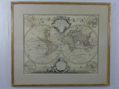
Sold2016Large Framed World Map w/ Latin InscriptionsLarge Framed World Map w/ Latin Inscriptions. Hand colored. Professionally framed and matted. Titled Mappe Monde. Measures 28 by 33 inches.See Sold Price
Sold2015Very large antique hand colored cart/mapVery large antique hand colored copyright 1906 (stamped 1907) George W. Eldridge chart/map showing Vineyard Sound Lightship to Chatham - details incl Nantucket & Martha's Vineyard in their entirety wSee Sold Price
Sold2020United States with large independent TexasHeading: (Texas) Author: Chambers, W. & R. Title: United States Place Published: Edinburgh Publisher: Date Published: 1841 Description: Engraved map, hand-colored in outlineSee Sold Price
Sold202117th C. French Engraving Map of N. Africa MoroccoFrench hand-colored engraving of North Africa, including Morrocco, parts of Algeria, Strait of Gibraltar. Dated 1655. Measures 16"H x 21"W visual image , 23.75"H x 27.75"W framed. Condition report: GoSee Sold Price
Sold2016Reports Upon Mineral Resources of the US 1867Heading: Author: Browne, J. Ross and James W. Taylor. Title: Reports Upon Mineral Resources of the United States Place Published: Washington Publisher:Government Printing Office Date Published:See Sold Price
May 09Hunt and Peck Estate Services, Inc.1867 United States General Land Office "Rapport af Chefen fur Land-Kontoret i Furenta Saterna."$200
17 hrs LeftJasper521736 LARGE MAP OF SILESIA POLAND SAGANENSIS antique 25 x 4 3/4" Duchy of Krnov$260
May 10Crescent City Auction GalleryIn the Manner of Sergio Bustamente (Mexico, b. 1949), Parrots, H.- 32 in., W.- 9 in., D.- 10 in. (2$325
May 18Rich Penn AuctionsSoda Fountain Hanging Parlor Lamp, copper & brass, c.1960 w/pierced 5 Cent & Ice Cream on shade$50(1 bid)


![Land office report w/ large colored map 1867: Heading: (General Land Office) Author: Title: Report of the Commissioner of the General Land Office for the Year 1866. Place Published: [Washington, D.C.] Publisher:Government Printing Office Da](https://p1.liveauctioneers.com/642/218849/112379315_1_x.jpg?height=310&quality=70&version=1631923877)


![6 Decorative Old Maps of 16th-18th Centuries: Set of six vintage "Decorative Old Maps of 16th, 17th, 18th Centuries" including colored maps of Europe, The Holy Land, Asia, Belgium, and Canada and the Great Lakes. [Sheets: 16" H x 20" W]. In good](https://p1.liveauctioneers.com/1221/316726/170695118_1_x.jpg?height=310&quality=70&version=1706931805)
![Boston: 35. Boston.Report of the Joint Committee on Public Lands in relation to the Public Garden. Large folding map by Ezra Lincoln. 52 pages. 8vo, printed wrappers; moderate wear. Boston, 1850 [75/100]City](https://p1.liveauctioneers.com/1352/196201/99068135_1_x.jpg?height=310&quality=70&version=1615028908)


![[AFRICAN AMERICANA] 1867 Free Black Couple’s Marriage License (1 of 2)](https://p1.liveauctioneers.com/7226/322253/173251687_1_x.jpg?height=282&quality=70&version=1710004847)


