Sold20211653 Merian Map of Northern Germany -- MeklenburgTitle: 1653 Merian Map of Northern Germany -- Meklenburg Ducatus Cartographer: Merian [family] Year / Place: 1653, Frankfurt Map Dimension (in.): 10.8 X 14.1 in. This is a very handsome map of the hisSee Sold Price
Sold2017Merian: Map of Heidelberg during 30 Years War, 1645Map: Wahre Contrafactur der Churfürstlichen Statt Heidelberg, und wie dieselbige vom General Tilly belägert und eingenommen worden Cartographer: Merian Place & Date: Frankfurt / 1645 Size: 15 3/8" xSee Sold Price
Sold2017Merian: Map of Denmark, Dania Regnum, 1638Title: Dania Regnum Map maker: Matthäus Merian, Neuwe Archontologica Cosmica Place and Year: Frankfurt, 1638 Dimensions: 35.5 x 28 cm (14 x 11 in) Technique: Copperplate engraving Coloring: UncoloredSee Sold Price
Sold2018Merian Map - NeapolisMerian Map - Neapolis- cooper engraving with hand-coloring, ca. 1680, some staining; together with reproduction after 19th c. Coastal map of Japan. 10 3/4 x 14''; 23 3/4 x 28 1/4'' (sheet)See Sold Price
Sold2019Merian maps of Poland & HungaryHeading: Author: Merian, Matthaus Title: Two maps of Eastern European countries Place Published: Frankfurt Publisher: Date Published: c.1640 Description: Includes:See Sold Price
Sold2019Constantinople (Istanbul)Title/Content of Map: Constantinople (Istanbul) Date: 1576-1590. Cartographer: By Porcacchi Size: 8x12”. Provenance: Republic of Venice Very decorative with prominent monuments and buildings shownSee Sold Price
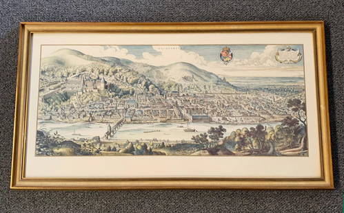
Sold20201620 Hand-colored Copperplate Engraved Haidelberga MapHeidelberg-Panorama von Matthaeus Merian 1620 - Description''': historic views of Heidelberg, Germany Birds Eye View Heidelberg 1620 Rare Copperplate Engraving by Matthäus Merian MAP - MatthäusSee Sold Price
Sold2016MAP MAKER MATTHAUS MERIAN"Tabula Russiae ex autographo, quod delineandum curavit Foedor filius Tzaris Boris . . . Map Maker: Matthaus Merian.", Frankfurt, 1640" Printed and hand colored on paper Dimensions: H12" x W 15" CondiSee Sold Price
Sold2021Merian 1650 Map of the NetherlandsMap by cartographer Merian featuring the western half of Holland including present-day provinces of North and South Holland. Also features several sailing ships, three compass roses, coat or arms, andSee Sold Price
Sold20181664 Merian small map of Bohemia (Czech Republic)Title: Bohemia Map maker: Matthäus Merian, Theatrum Europaeum Place and Year: Frankfurt, 1664 Dimensions: 15 x 18 cm (5.9 x 7 in) Technique: Copperplate engraving Coloring: Uncolored Condition RatingSee Sold Price
Sold2020Turkey 1858 Pair of Maps. Tallis & Rapkin, Istanbul"Turkey in Europe" and "Constantinople and the Bosphorus" Steel Engraved Maps Published 1858 by the London Printing and Publishing Co., London for "The History Of The War With Russia: Giving Full DetaSee Sold Price
Sold2024Matthaus Merian 1627 Antique Map Engraving "Virginia" from Theodore de Bry's "Grand Voyages" #1Antique 1627 map of Virginia by Matthaus Merian after John Smith's 1612 map, from Theodore de Bry's "Grand Voyages". Please see "The Philidelphia Print Shop" sheet shown in final photo. Good conditionSee Sold Price
Sold201617th century map of Russia by MerianHeading: Author: Merian, Matthaus, the elder Title: Tabula Russiae... alias dicta Moscovia Place Published: Frankfurt Publisher: Date Published: [c.1645] Description: Copper-engSee Sold Price
Sold2022Antique Map - Map of Europe - Map of Turkey & Hungary - Istanbul - Budapest - AnAntique map of Turkey & Hungary by Becker, published in London, c 1860. This antique map was engraved by the omnigraph method by Francis Paul Becker & Company, Patentees circa 1842, with contemporarySee Sold Price
Sold2023Matthaeus Merian. Moscua.[Map-Russia-Moscow] Matthaeus Merian. Moscua. Frankfurt, 1638. Hand-colored double-page engraved plan of Moscow on heavy laid paper. Beautiful bird's eye view of Moscow, with a key on the left hand siSee Sold Price
Sold2018View in Constantinople (Istanbul ) . RARE. 1770’s byTitle/Content of Map: View in Constantinople (Istanbul ) . RARE. 1770’s by Balthasar Probst. Augsburg Size: 19x13” Please note that this lot has a confidential reserve. When you leave a bid in advSee Sold Price
Sold2018Scarce Large 1634 Map of Americas by M. MerianRare Large Copperplate Engraved Map of the Americas Entitled "America Nouiter Delineata" by Matthäeus Merian (1593-1650) | | Title: America nouiter delineata Title (alt.): America noviter delineata |See Sold Price
Sold20211680 Map of Tuscany, Italy Attrib. MerianDESCRIPTION: Unknown cartographer, attributed to Merian. Decorative copper-engraved map of Tuscany in Italy with title cartouche with Saints Peter and Paul, galleons, and the Barberini seal, as CardinSee Sold Price
Sold2019CONSTANTINOPLE ISTANBUL antique town city mapTITLE/CONTENT OF MAP: 'CONSTANTINOPLE. STAMBOOL' DATE PRINTED: This map was originally published by The Society for the Diffusion of Useful Knowledge in 1840; this date is printed on the map. This ediSee Sold Price
Sold2024Matthaus Merian 1627 Antique Hand Colored Map "Virginia" from Theodore de Bry's "Grand Voyages" #2Antique 1627 hand-colored map of Virginia by Matthaus Merian after John Smith's 1612 map, from Theodore de Bry's "Grand Voyages". Good condition overall, with age-appropriate wear, repairs (see photosSee Sold Price
Sold2021Southern Russia, Ukraine and Black Sea area. 1762 byTitle: Southern Russia, Ukraine and Black Sea area. 1762 by Homann Heirs Date/Period: 1762 Size: 24 x 20 1/2" Material: Copperplate engraved Description: This map reaches from Moscow to Istanbul (ConsSee Sold Price
Sold2018Merian: Antique Chart of the Strait of Gibraltar, 1638Title/Content of Map: Tabula transitus Gibraltaris Cartographer: Merian Place & Date: Frankfurt / 1638 Size: 14" x 10 1/4" Condition: b&w; cleaned and backed Merian's scarce and detailed chartSee Sold Price
Sold2020Grp: Maps of AsiaGroup of maps of Asia. Includes Matthaus Merian (1593-1650), "Xuntien alias Quinzay," from the "Archontologia Cosmica," Frankfurt, ca. 1690. "Carte de la Baye de Chin-Chew ou Chang-Chew Avec les IslesSee Sold Price
Sold2022After Matthaus Merian German Castle Color EtchingItem/Description: Antique colored etching features a three-dimensional map view of "Maintz und Castel vor dem bombardement 1793" (Maintz and Castle before the 1793 bombing) by Matthaus Merian, The EldSee Sold Price
5 days LeftTrillium Antique Prints & Rare BooksDe Bry - Frontispiece: Caribbean and Central America$75
2 days LeftCedarburg Auction & Appraisals LLCSet of Four 17th Century Maps Showing All of Spain and Portugal$450(2 bids)
2 days LeftCedarburg Auction & Appraisals LLCRare 1877 Double sided map of Milwaukee and Wisconsin$80(6 bids)
BonhamsMaria Sibylla Merian (1647-1717); Five Plates, from Dissertatio de Generations et Metamorphosis ...$700(13 bids)
Jun 07Freeman's | Hindman[MAP]. TODESCHI, Pietro. [Nova et Acurata Totius Americae Tabula auct. G.I. Blaeu] America quarta$5,000
Jun 08Early American History Auctions1720 Colonial Northumberland County Virginia Manuscript Deed and Map Plot$400
Jun 07Freeman's | Hindman[MAP]. ORTELIUS, Abraham. Americae Sive Novi Orbis, Nova Descriptio. 1573.$1,000(1 bid)
3 days LeftAntiques Online AuctionsVintage Texas 1845 Map Printed in 1986, Compiled by John Davis$60(4 bids)


![1653 Merian Map of Northern Germany -- Meklenburg: Title: 1653 Merian Map of Northern Germany -- Meklenburg Ducatus Cartographer: Merian [family] Year / Place: 1653, Frankfurt Map Dimension (in.): 10.8 X 14.1 in. This is a very handsome map of the his](https://p1.liveauctioneers.com/5584/195879/98794817_1_x.jpg?height=310&quality=70&version=1614724478)


![17th century map of Russia by Merian: Heading: Author: Merian, Matthaus, the elder Title: Tabula Russiae... alias dicta Moscovia Place Published: Frankfurt Publisher: Date Published: [c.1645] Description: Copper-eng](https://p1.liveauctioneers.com/642/86438/44449706_1_x.jpg?height=310&quality=70&version=1458591928)

![Matthaeus Merian. Moscua.: [Map-Russia-Moscow] Matthaeus Merian. Moscua. Frankfurt, 1638. Hand-colored double-page engraved plan of Moscow on heavy laid paper. Beautiful bird's eye view of Moscow, with a key on the left hand si](https://p1.liveauctioneers.com/179/305680/163317457_1_x.jpg?height=310&quality=70&version=1697214016)


![[MAP]. TODESCHI, Pietro. [Nova et Acurata Totius Americae Tabula auct. G.I. Blaeu] America quarta (1 of 1)](https://p1.liveauctioneers.com/197/329395/177650542_1_x.jpg?height=282&quality=70&version=1715364962)


![[MAP]. ORTELIUS, Abraham. Americae Sive Novi Orbis, Nova Descriptio. 1573. (1 of 2)](https://p1.liveauctioneers.com/197/329395/177650534_1_x.jpg?height=282&quality=70&version=1715364962)


![[MAP]. ORTELIUS, Abraham. Turcici Imperii Descriptio.1592. (1 of 2)](https://p1.liveauctioneers.com/197/329395/177650538_1_x.jpg?height=282&quality=70&version=1715364962)