Sold2022MAP, Madagascar, SansonMadagascar. Nicolas Sanson, Isle de Madagascar ou de St. Laurens, Tiree de Sanut &c., from Geographise en Historise Werelt Beschryving, 1699 (circa). Black & White. Finely engraved, decorative map ofSee Sold Price
Sold20181683 Sanson Map of the Great Lakes and the Upper EastTitle/Content of Map: 1683 Sanson Map of the Great Lakes and the Upper East Coast -- Le Canada, ou Nouvelle France, &c. Tiree de diverses Relations des Francois, Anglois, Hollandois, &c. Date: 1683, PSee Sold Price
Sold20211683 Sanson Map Great Lakes to Newfoundland -- LeTitle: 1683 Sanson Map Great Lakes to Newfoundland -- Le Canada, ou Nouvelle France, &c. Tiree de diverses Relations des Francois, Anglois, Hollandois, &c. Cartographer: N Sanson Year / Place: 1683 c.See Sold Price
Sold20181683 Sanson Map of the Great Lakes and the Upper EastTitle/Content of Map: 1683 Sanson Map of the Great Lakes and the Upper East Coast -- Le Canada, ou Nouvelle France, &c. Tiree de diverses Relations des Francois, Anglois, Hollandois, &c. Date Printed:See Sold Price
Sold20231652 Sanson Map of the World -- L'Hydrographie ou Descriprion de L'Eau c'est a dire des Mers,Title: 1652 Sanson Map of the World -- L'Hydrographie ou Descriprion de L'Eau c'est a dire des Mers, Golfes, Lacs, Destroits, et Rivieres principales, qui font dans la Surface du Globe Terrestre . . .See Sold Price
Sold2022Alexis Hubert Jaillot and Nicolas Sanson - Map of the Grand Duchy of Moscow, Etching, 1708.Alexis Hubert Jaillot (French, 1632-1712) and Nicolas Sanson (French, 1600-1667) - Map of the White Russia or the Grand Duchy of Moscow, Etching, 1708. Title: Les Estats du Czaar de Russie Blanche ouSee Sold Price
Sold2020Nicolas Sanson Map of AsiaNicolas Sanson (1600-1667) "L'Asie divisee en ses Principales Regions, et ou se peuvent voir l'estendue, Des Empires, Monarchies, Royaumes, et Estats," Paris: Jaillot, ca. 1719. Hand colored map of AsSee Sold Price
Sold2024Nicolas Sanson - Map of Asia / Asia divided into its Principal RegionsCopper engraving, 1600s/1700s, "Asia divided into its Principal Regions." By Mr. Sanson, Geographer Ordinary to the King. Size: 58 cm x 88 cm.See Sold Price
Sold2018RARE 17TH C. SANSON MAP OF LUXEMBOURGAlexis-Hubert Jaillot (c. 1632-1712); Nicolas Sanson (1600-1667) "Le Duche de Luxembourg Divise en Quarter Walon et Allemand....", hand colored engraving, published 1700 from earlier plates, Paris, frSee Sold Price
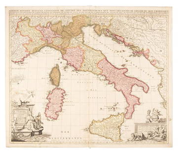
Sold2019Sanson map of Italy 1701Heading: Author: Sanson, Nicolas Title: L'Italie Divisee Suivant l'Estendue de Toutes ses Sourverainetes... Place Published: Amsterdam Publisher:Pieter Schenk Date Published: 1701 DescSee Sold Price
Sold2019MAP - Belarus. SansonBelarus. N. Sanson/Mariette, Partie de Lithuanie ou est le Palatinat de Nowogrodeck Litawiski, Subdivise en ses Chastellenies..., 1665 (dated). Hand Color. This map details much of present-day southweSee Sold Price
Sold20201598 c. de Bry Map of Madagascar -- Insula Madagascar,Title/Content of Map: 1598 c. de Bry Map of Madagascar -- Insula Madagascar, Alias S. Laurentii… / Insula de S. Laurety Cartographer: T de Bry Year/Place: 1598 c., Frankfurt Size: 5.5 X 7.6 in. ThisSee Sold Price
Sold20211652 Sanson Map of the Arabian Peninsula and the RedTitle: 1652 Sanson Map of the Arabian Peninsula and the Red Sea -- L'Arabie Petree, Deserte, et Heureuse Cartographer: N Sanson Year / Place: 1652, Paris Map Dimension (in.): 7.5 X 9.5 in. This is a rSee Sold Price
Sold2023MAP, Alps, SansonAlps - Italy, Switzerland, Austria. Nicolas Sanson, Le Tirol, souz le Nom Duquel s'Entendent le Comte de Tirol; puis les Comtes de Bregentz, Feldkirck, Montfort, Pludentz, &c. Sujets..., from Cartes GSee Sold Price
Sold2023Sanson map of ancient Asia 1650Heading: Author: Sanson, Nicolas Title: Asia Vetus Place Published: Paris Publisher: Date Published: [1650] Description: Copper-engraved map, hand-colored in outline; colored decorSee Sold Price
Sold20191700 c. Sanson Map of the Arabian Peninsula and the RedTitle/Content of Map: 1700 c. Sanson Map of the Arabian Peninsula and the Red Sea -- Arabia Petrea, Deserta et Felix Per N. Sanson Date: c. 1700 Cartographer: Based on N. Sanson Size: 7.5 X 9.5 in. ThSee Sold Price
Sold20231683 Sanson Map of South America -- Amerique MeridionaleTitle: 1683 Sanson Map of South America -- Amerique Meridionale Cartographer: N Sanson Year / Place: 1683, Paris Map Dimension (in.): 7.8 X 10/8 in. This is a superb map of South America with a charmiSee Sold Price
Sold2017Didot/Bellin: Antique Map of Madagascar, 1747Map: Carte De Toute Les Isles Connues a La Coste De Languebar Et Madagascar Publication Date: 1747 Authors: DIDOT, BELLIN, JACQUES NICOLAS, ELDER (1703-1772) Publisher: DIDOT Size: Octavo – 9.25 H xSee Sold Price
Sold2024MAP, Africa, SansonWestern Africa, Cape Verde Islands. Nicolas Sanson, D'Eilanden van Capo Verde, de Kust en't Landt der Negeren..., from Algemeene Weereld-Beschryving…, 1705 (published). Hand Color. This is an attracSee Sold Price
Sold20201690 Hoffmann Map of Madagascar -- Insula MadagascarTitle: 1690 Hoffmann Map of Madagascar -- Insula Madagascar Cartographer: J Hoffmann Year / Place: 1690 c., Nurnberg Map Dimension (in.): 3.9 X 4.7 in. This is an excellent smaller map of Madagascar aSee Sold Price
Sold20211749 Robert de Vaugondy Map of Madagascar and IndianTitle: 1749 Robert de Vaugondy Map of Madagascar and Indian Ocean Islands -- Isle de Madagascar ou de St. Laurent et Isles Circonvoisines Cartographer: D. Robert de Vaugondy Year / Place: 1749, ParisSee Sold Price
Sold2020Nicolas Sanson Map of Morea Greece 1692Nicolas Sanson (1600-1677), "La Moree et les Isles de Zante, Cafalonie, Ste Maure, Cerigo, &c." Paris: Hubert Jaillot, 1692. This hand-colored map depicts Morea, the southern part of Greece, with theSee Sold Price
Sold20191705 Sanson map of Russia w/huge marginsReserve Reduced! Beautiful specimen with modern hand coloring painstakingly applied. A strongly engraved map of European Russia showing its political divisions, major topographical features, cities anSee Sold Price
Sold20231700 Sanson Map of Sri Lanka and the Maldives -- Ceylan, et les MaldivesTitle/Content: 1700 Sanson Map of Sri Lanka and the Maldives -- Ceylan, et les Maldives Cartographer: N Sanson Year/Place: 1700, Paris Dimensions: 7.2 X 9.5 in. Description: This is an exquisite map oSee Sold Price
1 day LeftJasper521683 Sanson Map of the Caribbean -- Les Isles Antilles, &c Entre Lesquelles sont les Lucayes, et les$170
May 09Hunt and Peck Estate Services, Inc.Sanson & Jaillot "Le Royaume de Naples Divisé en Douze Provinces"$200
2 days LeftJasper52AFRICAN ISLANDS Mauritius Madagascar Madeira Canaries St Helena Socotra 1910 map$20
1 day LeftJasper521820 LOSS of WINTERTON EAST INDIAMAN WRECKED on MADAGASCAR COAST in 1792 antique$130
May 14Fleischer's Auctions1755 Map Partie de l'Amerique Septentrionale, qui comprend Le Cours de L'Ohio...$200(3 bids)
6 days LeftTremont AuctionsJohn Speed and Francis Lamb "Map of New England and New York", ca. 1676. Hand colored engraved map$900(3 bids)
6 days LeftTremont Auctions17th century original map 1676 "Virginia and Maryland" by John Speed. 2 sided framing. Overall:$325(2 bids)
6 days LeftTremont Auctions18th century map of New Jersey. "A New and Accurate Map of New Jersey". W. Long, London. Map size 13$100
May 11Crescent City Auction GalleryWilliam H. Williams (1817-1886), New Orleans "Map of the Sixth District and Carrollton," 1871, H.-$650
May 12Schilb Antiquarian Rare Books1977 JRR Tolkien 1st ed 1st Printing Silmarillion Lord of the Rings + MAP + DJ$200(5 bids)
3 days LeftDixon's Crumpton AuctionPre-Central Park Map of New York City, David H. Burr / Simeon DeWitt 1829$125(3 bids)


![Sanson map of ancient Asia 1650: Heading: Author: Sanson, Nicolas Title: Asia Vetus Place Published: Paris Publisher: Date Published: [1650] Description: Copper-engraved map, hand-colored in outline; colored decor](https://p1.liveauctioneers.com/642/310901/166355383_1_x.jpg?height=310&quality=70&version=1701367957)


