Sold2021Map of Public Surveys in California to Accompany ReportPublication Date: 1862 Title: Map of Public Surveys in California to Accompany Report of Surveyor Genl. 1862. Cartographer: U.S. SURVEYOR GENERAL FOR CALIFORNIA Publisher: HOUSE OF REPRESENTATIVES HeiSee Sold Price
Sold2016John C. Hays: California 1856Map: Map of Public Surveys in California to Accompany Report of Surveyor General Publishing: John C. Hays: Washington DC Date: 1856 Size: 35.5 x 31.25 inches Large map of all of California showing theSee Sold Price
Sold2020T Sketch of Public Surveys in New Mexico.Title/Content of Map: T Sketch of Public Surveys in New Mexico. Publication Date: 1856 Cartographer: PELHAM, WILLIAM Publisher: SURVEYOR GENERAL'S OFFICE Description: "To accompany report of surveyorSee Sold Price
Sold2019"Map of Public Surveys in California," 1855, H.- 37 1/2"Map of Public Surveys in California," 1855, H.- 37 1/2 in., W.- 31 3/4 in.See Sold Price
Sold2019"Map of Public Surveys in California, Public Grants,""Map of Public Surveys in California, Public Grants," 1862, H. - 25 in., W. - 17 5/8 in.See Sold Price
Sold20151863 Sketch of Public Surveys in New MexicoSketch of public surveys in New Mexico to accompany the annual report of the survey general for 1863. 1863Dimensions: 18" X 17"60 Mile ScaleNote: Slightly acidic along folds. House of RepresentativesSee Sold Price
Sold2023Williamson, Lieut. R. S. 1856 LG HC Map. California - First Geological Map"Geological Map of a Part of the State of California" Explored in 1855 by Lieut R. S. Williamson. Prepared to accompany the Report of William P. Blake. THE FIRST GEOLOGY MAP OF CALIFORNIA. Hand ColoreSee Sold Price
Sold2019GLO Map of Washington Territory, ca 1860-61**Originally Listed At $100** Map of a Part of Washington Territory to Accompany the Report of the Surveyor General 1860-61. A very collectible early survey map of the Washington Territory that was coSee Sold Price
Sold2017Map of California & Nevada Borax Fields 1883Heading: (California & Nevada) Author: Title: Map of California and Nevada showing the locality of the principal borax fields to accompany the third annual report of the State Mineralogist of CaliforSee Sold Price
Sold2018U.S Coast Survey 1853 Map. Cortez Bank, California"Cortez Bank on the Western Coast of the United States" Electrotype Map Published 1843-65, Washington for "Report of the Superintendent of the U.S. Coast Survey..." Published under the supervision andSee Sold Price
Sold2017Map of Washington Territory, 1859Map: 1859 Washington Territory Map -- Map of a Part of Washington Territory to Accompany the report of the Surveyor General Cartographer: US State Surveys (J Tilton) Year / Place: 1859 Washington MapSee Sold Price
Sold20231894 ALASKA California 18 MAPS United States Geodetic Surveys State Boundaries1894 ALASKA California 18 MAPS United States Geodetic Surveys State Boundaries Throughout the 19th-century, the United States government published countless reports and surveys on natural history of ASee Sold Price
Sold2023Williamson, Lieut. R. S. 1856 Map. California, New Mexico, Texas, Mexico"United States & Mexican Boundary Survery" Lithograph Map Published 1853-61, Washington for "Reports of explorations and surveys, to ascertain the most practicable and economical route for a railroadSee Sold Price
Sold2023Williamson, Lieut. R. S. 1856 Map. Vicinity of San Francisco California"Geological Map of the Vicinity of San Francisco" by William P. Blake. Lithograph Map Published 1853-61, Washington for "Reports of explorations and surveys, to ascertain the most practicable and econSee Sold Price
Sold2023Williamson, Lieut. R. S. 1856 HC Map. San Diego & Colorado River California"Geological Map of the Country Between San Diego and the Colorado River California" By W. P. Blake. Hand Colored Lithograph Map Published 1853-61, Washington for "Reports of explorations and surveys,See Sold Price
Sold2023Williamson, Lieut. R. S. 1856 LG Chart. California - Colorado River to the Pacific Ocean"Geological Section from the Colorado River to the Pacific Ocean" by William P. Blake. Lithograph Map Published 1853-61, Washington for "Reports of explorations and surveys, to ascertain the most pracSee Sold Price
Sold2023Williamson, Lieut. R. S. 1856 LG Chart. California - Coast Mountains & Sierra Nevada"Geological Section of the Coast Mountains and Sierra Nevada" by W. P. Blake. Lithograph Map Published 1853-61, Washington for "Reports of explorations and surveys, to ascertain the most practicable aSee Sold Price
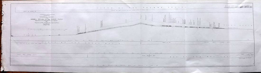
Sold2023Williamson, Lieut. R. S. 1856 LG Chart. California - Sierra Nevada & Tejon Pass"Goelogical Section of the Sierra Nevada at the Tejon Pass" by R. S. Williamson. Lithograph Map Published 1853-61, Washington for "Reports of explorations and surveys, to ascertain the most practicablSee Sold Price
Sold2023Williamson, Lieut. R. S. 1856 LG Chart. California - Bernadino Pass, San Bernardino, Colorado Desert"Geological Sections of the Bernadino Pass" Lithograph Map Published 1853-61, Washington for "Reports of explorations and surveys, to ascertain the most practicable and economical route for a railroadSee Sold Price
Sold2023Williamson, Lieut. R. S. 1856 LG Chart. California - Colorado Desert"Sections of the Colorado Desert" Explored by Lieut R. S. Williamson. Lithograph Map Published 1853-61, Washington for "Reports of explorations and surveys, to ascertain the most practicable and econoSee Sold Price
Sold2020Sketch of the Public Surveys in Wisconsin and TerritoryTitle/Content of Map: Sketch of the Public Surveys in Wisconsin and Territory of Minnesota Cartographer: LEWIS, WARNER Date: 1855 Publisher: SURVEYOR GENERALS' OFFICE Size: 17Height - 21Width SurveyorSee Sold Price
Sold20221853 Immense Williamson Map of California -- General Map of Explorations and Surveys In CaliforniaTitle: 1853 Immense Williamson Map of California -- General Map of Explorations and Surveys In California under the direction of the Hon. Jefferson Davis, Secretary of War… Cartographer: R WilliSee Sold Price
Sold2021Report on California with maps 1850Heading: (California & New Mexico) Author: [Taylor, Zachary] Title: California and New Mexico: Message of the President of the United States, Transmitting information... on the Subject of California aSee Sold Price
Sold2019U S Coast Survey 1896 Map. California Nevada Boundary"Boundary Survey between California and Nevada. Sheet 1" Lithograph Map Published 1896, Washington for "U.S. Coast and Geodetic Survey" Folds as issued. Rare. Paper Size: 20 x 19.5 inch (50 x 49cm) GoSee Sold Price
4 days LeftHunt and Peck Estate Services, Inc.1867 United States General Land Office "Rapport af Chefen fur Land-Kontoret i Furenta Saterna."$200
May 16Potter & Potter AuctionsPictorial Map of Hollywood and Vicinity / Hollywood Film Ca...$125(1 bid)
May 14Akiba Galleries(2 Pc) Allain Manesson Mallet Description De L'Univers 2 Vol. German Translation$200(1 bid)
Featured2 days LeftJasper52Map Showing Distribution of Pinus Palustris (Longleaf Pine) & Pinus Cubensis (Cuban Pine) | Pinus$35
Featured2 days LeftJasper52GIA Certified 49.73ct No Heat Color Change Star Sapphire Diamonds Ring 18kt$54,000
May 18PUBLIC SALEMid-Century Modern Polished Steel & Travertine Coffee Table, Pace Collection$250(5 bids)
May 18PUBLIC SALEMid-Century Danish Modern Leather Sofa, Borge Mogensen Fredericia Stolefabrik$125(2 bids)


![Report on California with maps 1850: Heading: (California & New Mexico) Author: [Taylor, Zachary] Title: California and New Mexico: Message of the President of the United States, Transmitting information... on the Subject of California a](https://p1.liveauctioneers.com/642/197268/99581926_1_x.jpg?height=310&quality=70&version=1615593525)


