Sold2019GLO Map of Washington Territory, ca 1860-61**Originally Listed At $100** Map of a Part of Washington Territory to Accompany the Report of the Surveyor General 1860-61. A very collectible early survey map of the Washington Territory that was coSee Sold Price
Sold2021Map of a Part of Washington Territory to AccompanyPublication Date: 1861Title: Map of a Part of Washington Territory to Accompany Report Of the Surveyor General 1860-'61. Cartographer: TILTON, JAMES Publisher: SURVEYOR GENERAL Height: 22 Width: 28 MaSee Sold Price
Sold201819th C Map Oregon, Washington, Idaho, & Part of Montana**Originally Listed At $100** Samuel Augustus Mitchell Jr. (American), "Map of Oregon, Washington, Idaho and Part of Montana." ca. 1860. A fabulous example of S. A. Mitchell Junior's 1866 map of WashiSee Sold Price
Sold2017Map of Washington Territory, 1859Map: 1859 Washington Territory Map -- Map of a Part of Washington Territory to Accompany the report of the Surveyor General Cartographer: US State Surveys (J Tilton) Year / Place: 1859 Washington MapSee Sold Price
Sold2017Untitled. [Fanciful View Of Washington, D.c.]Untitled. [Fanciful View Of Washington, D.C.] ca. 1860, English. T. Packer, Evans & Co. Chromolithograph in colors. 8.6 x 11.5" Sheet music illustration for 'The American Galop," by Thomas Adams. PrinSee Sold Price
Sold20211883 Map of the Washington TerritoryAuthor: Cram Title: 1883 Map of the Washington Territory Medium: Ink on Paper Dimensions: 13.5"X11" Map of Washington territory dated 1883. Engraved and published by George Cram in Chicago. Color codeSee Sold Price
Sold20211885 Washington Territory MapTitle: 1885 Washington Territory Map Author: Watson Medium: Ink on Paper Dimensions: 13.5"X11" Description: Washington Territory map dated 1885. Printed and published by Watson in Chicago. Part of hisSee Sold Price
Sold20231859 Map of Washington and Oregon territory includes modern Idaho by ColtonTitle: 1859 Map of Washington and Oregon territory includes modern Idaho by Colton Date/Period: 1859 Materials: Steel engraved Size: 17 1/2 x 14 1/2” Washington and Oregon territories with whatSee Sold Price
Sold2017Fullarton: Antique Map of Texas & Indian Territory 1860Map: 1860 Fullarton Map of Texas (East/Central), Indian Territory, Louisiana and Arkansas -- United States North America According to Calvin Smith& Tanner . . . South Central Section. Comprising TexasSee Sold Price
Sold202119th Century Map of Edo (Tokyo)Large map of Edo (Tokyo), ca. 1860. Dimensions: 114X93 cm. Good-fair condition (slight tears to folding lines, one panel detached). Provenance: Prof. Avraham Altman collection.Our sincere thanks to liSee Sold Price
Sold2021Map of That Part of Washington Territory Lying West OfPublication Date: 1856Title: Map of That Part of Washington Territory Lying West Of the Cascade Mounts. Cartographer: TILTON, JAMES Publisher: P.S. DUVAL & SON LITH. Height: 15.25 Width: 10.25 Map shoSee Sold Price
Sold2021Map of That Part of Washington Territory Lying West OfPublication Date: 1857 Title: Map of That Part of Washington Territory Lying West Of the Cascade Mounts. Cartographer: TILTON, JAMES Publisher: P.S. DUVAL & SON LITH. Height: 15 Width: 10.3 Map showinSee Sold Price
Sold2018Ca 1860 Cruchley Tourist Map of EuropeCa 1860 Cruchley Tourist Map of Europe-- Dimensions: ---See Sold Price
Sold2017Mitchell: Map of the United States & Territories, 1860Map: United States & Territories Maker: Mitchell Date: 1860 Size: 13.25 x 21.25 inches Condition: Some light soil marks in margin. Nice original hand coloring. Three very tiny spots in map. Very niceSee Sold Price
Sold2023Williamson, Lieut. R. S. 1856 Map. California, New Mexico, Texas, Mexico"United States & Mexican Boundary Survery" Lithograph Map Published 1853-61, Washington for "Reports of explorations and surveys, to ascertain the most practicable and economical route for a railroadSee Sold Price
Sold2023Williamson, Lieut. R. S. 1856 LG Chart. California - Bernardino Sierra, San Pedro"Geological Section of the Bernardino Sierra from the Great Basin to the Pacific ocean at San Pedro" by William P. Blake. Lithograph Map Published 1853-61, Washington for "Reports of explorations andSee Sold Price
Sold2023Williamson, Lieut. R. S. 1856 Map. Vicinity of San Francisco California"Geological Map of the Vicinity of San Francisco" by William P. Blake. Lithograph Map Published 1853-61, Washington for "Reports of explorations and surveys, to ascertain the most practicable and econSee Sold Price
Sold2023Williamson, Lieut. R. S. 1856 HC Map. San Diego & Colorado River California"Geological Map of the Country Between San Diego and the Colorado River California" By W. P. Blake. Hand Colored Lithograph Map Published 1853-61, Washington for "Reports of explorations and surveys,See Sold Price
Sold2023Williamson, Lieut. R. S. 1856 Map. California - Tejon Pass & Canada de las Uvas"Geological Map of the Tejon Pass & Canada de las Uvas and the Vicinity. Including the Pass of San Francisco & Williamsons Pass"Lithograph Map Published 1853-61, Washington for "Reports of explorationSee Sold Price
Sold2023Williamson, Lieut. R. S. 1856 LG Chart. California - Colorado River to the Pacific Ocean"Geological Section from the Colorado River to the Pacific Ocean" by William P. Blake. Lithograph Map Published 1853-61, Washington for "Reports of explorations and surveys, to ascertain the most pracSee Sold Price
Sold2023Williamson, Lieut. R. S. 1856 LG Chart. California - Coast Mountains & Sierra Nevada"Geological Section of the Coast Mountains and Sierra Nevada" by W. P. Blake. Lithograph Map Published 1853-61, Washington for "Reports of explorations and surveys, to ascertain the most practicable aSee Sold Price
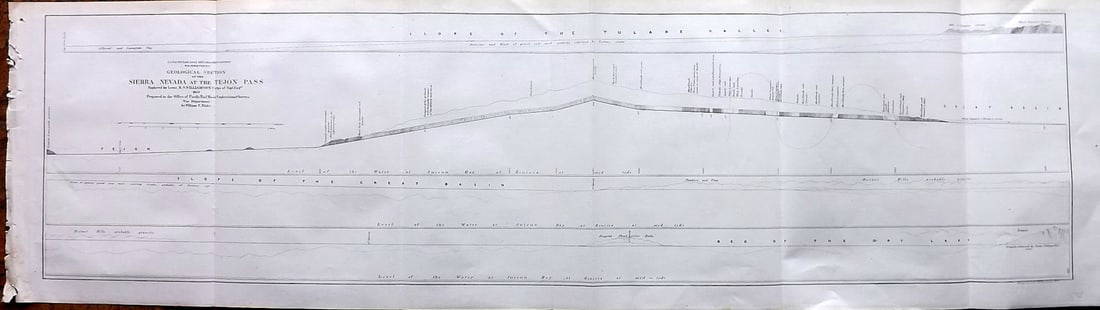
Sold2023Williamson, Lieut. R. S. 1856 LG Chart. California - Sierra Nevada & Tejon Pass"Goelogical Section of the Sierra Nevada at the Tejon Pass" by R. S. Williamson. Lithograph Map Published 1853-61, Washington for "Reports of explorations and surveys, to ascertain the most practicablSee Sold Price
Sold2023Williamson, Lieut. R. S. 1856 LG Chart. California - Bernadino Pass, San Bernardino, Colorado Desert"Geological Sections of the Bernadino Pass" Lithograph Map Published 1853-61, Washington for "Reports of explorations and surveys, to ascertain the most practicable and economical route for a railroadSee Sold Price
6 days LeftHunt and Peck Estate Services, Inc.1867 United States General Land Office "Rapport af Chefen fur Land-Kontoret i Furenta Saterna."$200
May 16DuMouchellesFrench Second Empire Upholstered Mahogany Benches, Ormolu Mounts, Ca. 1860, H 27" W 25.5" Depth$375
May 16DuMouchellesMeissen (German) & Ernst Teichert (Meissen, Germany) Blue Onion Porcelain Serving Dishes, Ca.$300
May 16DuMouchellesJohann Kaendler (German, 18th C.) for Meissen (German) Porcelain Figural Grouping, Allegory of$300(1 bid)
May 16DuMouchellesMeissen (German) & Ernst Teichert (Meissen, Germany) Blue Onion Porcelain Teacups, Plates & Egg$450
1 day LeftTrillium Antique Prints & Rare BooksBlaeu?s Le Theatre du Monde? ? Volume 3 with 57 Fold Out Maps with Original Hand-coloring, 4 Smaller$1,000(1 bid)
May 15University ArchivesJ. Q. Adams, Fillmore, Buchanan And 180 More! Autograph Album Members of Congress$1,000(1 bid)
May 15University ArchivesRonald Reagan as Pres Handwritten, Signed Results of Telephone Calls to World Leaders$1,700
May 29Carlo Bonte AuctionsA large Japanese woodblock print by Kitao Masanobu (1761-1816) and a triptych by Kunisada€200
May 12Ararity AuctionsAntique American Painted Stained Leaded Glass Window George Washington Portrait$26(2 bids)


![Untitled. [Fanciful View Of Washington, D.c.]: Untitled. [Fanciful View Of Washington, D.C.] ca. 1860, English. T. Packer, Evans & Co. Chromolithograph in colors. 8.6 x 11.5" Sheet music illustration for 'The American Galop," by Thomas Adams. Prin](https://p1.liveauctioneers.com/5584/101795/52004374_1_x.jpg?height=310&quality=70&version=1490388301)


![[LEUTZE, Emauel (1816-1868), artist]. Grant at the Capture ... (1 of 1)](https://p1.liveauctioneers.com/928/328184/176813677_1_x.jpg?height=282&quality=70&version=1714496988)


![[Yakima War] William Francis Gaston Unpublished Ambrotype (1 of 1)](https://p1.liveauctioneers.com/7226/322253/173251526_1_x.jpg?height=282&quality=70&version=1710356357)


