Sold2016Map of Vermont, 1898Title: Map of Vermont Maker: Rand, McNally & Co. Date: 1898 From New Standard Atlas of the World Indexed Size: 15 x 21 inches No Reserve: This lot starts at $1 and has no reserve as a courtesy so thatSee Sold Price
Sold2022Alaska Map, 1898 [155038]1898 Alaska route of military expedition in charge of Captain EF Glenn, from Knik Arm to Tanana River. 31x12".Date: Country (if not USA): State: AlaskaCity: Provenance:See Sold Price
Sold2021Reginald Marsh, Minsky's Chorus, EtchingProperty from a Private Collection, Savannah, GA Description: Reginald Marsh (New York/Vermont, 1898-1954), Minsky's Chorus, Etching, signed, titled, and numbered 'State III, 4/12' in pencil lowerSee Sold Price
Sold2017Reginald Marsh Merry-Go-Round Carousel EngravingNEW YORK/VERMONT, 1898-1954 An engraving of a vogue girl riding a carousel horse by Reginald Marsh. Titled "Merry-Go-Round", the work is initialed "R.M", dated "1943", and retains original Hirschl & ASee Sold Price
Sold2018Reginald Marsh, Drawing of a Woman, SignedReginald Marsh (American (New York/Vermont), 1898-1954), "Woman in Pink", colored pencil and pencil drawing on paper, pencil signed lower right. Figural drawing depicting a young woman with curled bloSee Sold Price
Sold20201898 Rand McNally Chart of World Flags -- [World Flags]Title/Content of Map: 1898 Rand McNally Chart of World Flags -- [World Flags] Cartographer: Rand McNally Year/Place: 1898, Chicago Size: 12.5 X 9.2 in. This is a very nice chart of 60 world flags, orgSee Sold Price
Sold2017Reginald Marsh Burlesque Social Realist EngravingNEW YORK/ VERMONT, 1898-1954 An engraving on wove paper of a burlesque dancer by Reginald Marsh. Titled "G-String", the work is one of 23 proofs pencil signed and initialed by Reginalds wife Felicia MSee Sold Price
Sold2018Reginald Marsh(New York/Vermont, 1898-1954) Oil on board of city river scene, signed lower right. Good overall condition, upper right hand corner having a chip to the board. Housed in period frame. Sight size: H10See Sold Price
Sold20201898 Rand McNally Chart of Tallest Buildings -- NotableTitle/Content of Map: 1898 Rand McNally Chart of Tallest Buildings -- Notable High Buildings of the World Cartographer: Rand McNally Year/Place: 1898, Chicago Size: 12.5 X 9.2 in. This is a very niceSee Sold Price
Sold20201898 Rand McNally Map of Texas and IndianTitle/Content of Map: 1898 Rand McNally Map of Texas and Indian Territory/Oklahoma -- Texas; Oklahoma and Indian Territory Date: 1898, Chicago Cartographer: Rand McNally Size: 9.2 x 12.5 in. This mapSee Sold Price
Sold2017Rand McNally Map India, Burma, Nepal and Ceylon, 1898Map: 1898 Rand McNally India, Burma, Nepal and Ceylon -- India Cartographer: Rand McNally Year / Place: 1898, Chicago Map Dimension: 26.2 X 19.2 in. A very nice map of South East Asia. Highly detailedSee Sold Price
Sold20191898 Rand McNally Map of Louisiana -- [Louisiana]Title/Content of Map: 1898 Rand McNally Map of Louisiana -- [Louisiana] Date: 1898 Chicago Cartographer: Rand Mcnally Size: 13 X 19.4 in. This is a highly detailed, larger map of Lousiana. It color coSee Sold Price
Sold20201898 Rand McNally Map of Asia from China, Japan toTitle/Content of Map: 1898 Rand McNally Map of Asia from China, Japan to Indonesia -- China, French Indo-China, Siam, Malaysia & Korea Cartographer: Rand McNally Year/Place: 1898, Chicago Size: 18.6 xSee Sold Price
Sold2017Map of Hawaii and the Philippines, 1898Map: 1898 Map of Hawaii and the Philippines -- The Philippine Islands and Hawaii Cartographer: Century Co. Year / Place: 1898, New York Map Dimensions: 10.4 x 14.7 in. An unsual, rare and interestingSee Sold Price
Sold20201898 c. Cram View of the Proposed Nicaraguan Canal --Title/Content of Map: 1898 c. Cram View of the Proposed Nicaraguan Canal -- Birds Eye View of the Maritime Canal of Nicaragua Cartographer: G Cram Year/Place: 1898 c., Chicago Size: 7.8 X 12.4 in. ThiSee Sold Price
Sold20191898 Rand McNally Map of San FranciscoTitle/Content of Map: 1898 Rand McNally Map of San Francisco Date: 1905, Chicago Cartographer: Rand McNally Size: 13.5 x 11 in. A very nice map od San Francisco from the late 19th century. The map comSee Sold Price
Sold20201898 Rand McNally Map of Utah [verso] Wyoming -- UtahTitle/Content of Map: 1898 Rand McNally Map of Utah [verso] Wyoming -- Utah [verso] Wyoming Cartographer: Rand McNally Year/Place: 1898 Chicago Size: 12.2 X 9.3 in. This is very nice map of Utah and WSee Sold Price
Sold20201898 Rand McNally Map of the United States -- UnitedTitle/Content of Map: 1898 Rand McNally Map of the United States -- United States Cartographer: Rand McNally Year/Place: 1898, Chicago Size: 9.2 X 12.4 in. This is a quite detailed political map of thSee Sold Price
Sold20201898 Rand McNally Map of the United States -- UnitedTitle/Content of Map: 1898 Rand McNally Map of the United States -- United States Cartographer: Rand McNally Year/Place: 1898, Chicago Size: 9.2 X 12.4 in. This is a quite detailed political map of thSee Sold Price
Sold20181898 Cram Map of Toronto -- TorontoReserve Reduced! Title/Content of Map: 1898 Cram Map of Toronto -- Toronto Date: 1898, Chicago Cartographer: G Cram Size: 9.6 X 12 in. This is a nice, and highly detailed map of Toronto. Shown are roaSee Sold Price
Sold20191898 Cram map of the Bahamas [verso] Haiti, DominicanTitle/Content of Map: 1898 Cram map of the Bahamas [verso] Haiti, Dominican Republic and Jamaica -- Map of the Bahama Islands [verso] Map of Jamaica, Haiti and San Domingo Date: 1898, ChicagoCartograpSee Sold Price
Sold2020Vermont 1897Title/Content of Map: Vermont 1897 Date Printed: 1897 Material/Medium: Paper Size: approx 22x14.5 inches Additional Info: Cram's Universal Atlas Reserve: $30.00 Shipping: Domestic: Flat-rate of $15.00See Sold Price
Sold2018Colton: Antique Map of Vermont, 1859Title/Content of Map: Vermont by Colton Date Printed: 1859 Cartographer: H.J. Colton Material/Medium: Paper Size: 17 1/2" x 15" Hand colored,engraved. Published in New York in 'Colton's General Atlas.See Sold Price
Sold2017Bradford: Antique Map of Vermont, 1838Title/Content of Map: Vermont by Bradford Date Printed: 1838/1841 Cartographer: Thomas G. Bradford Material/Medium: Paper Size: 13" x 15" A General Atlas of the World with a seperate Map of each of thSee Sold Price
3 days LeftJasper52Rand, McNally & Co.'S Map of the Western Hemisphere. Globe Series Compiled from the Latest And Most$340
3 days LeftJasper521930 Map of Hollywood, California -- Security-First National Bank Map of Hollywood and Vicinity$280
May 09Hunt and Peck Estate Services, Inc.Lot of 3 small maps from Scott's Gazeteer "Vermont, New Hampshire and N.W. Territories"$100
Featured10 hrs LeftGold Coast AuctioneersSabra Field ( US Vermont b. 1935) North Road I II and III$1,100(10 bids)
6 days LeftJay Anderson AuctionDated 1898 & signed Aan, Rosemaled Norwegian Trunk found near Rochester MN. Good original paint &$225(3 bids)
May 14Fleischer's Auctions1755 Map Partie de l'Amerique Septentrionale, qui comprend Le Cours de L'Ohio...$200(3 bids)
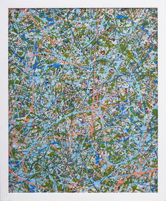
May 05Curated Gallery AuctionsFredric Karoly (1898 - 1987) Important Mid Century Abstract Action Painting Signed Titled Catalogued$425(6 bids)
10 hrs LeftGold Coast AuctioneersSabra Field (Vermont b. 1935) Middlebury College Bicentennial View$250(3 bids)


![Alaska Map, 1898 [155038]: 1898 Alaska route of military expedition in charge of Captain EF Glenn, from Knik Arm to Tanana River. 31x12".Date: Country (if not USA): State: AlaskaCity: Provenance:](https://p1.liveauctioneers.com/2699/258185/134287533_1_x.jpg?height=310&quality=70&version=1660347389)


![1898 Rand McNally Chart of World Flags -- [World Flags]: Title/Content of Map: 1898 Rand McNally Chart of World Flags -- [World Flags] Cartographer: Rand McNally Year/Place: 1898, Chicago Size: 12.5 X 9.2 in. This is a very nice chart of 60 world flags, org](https://p1.liveauctioneers.com/5584/173638/87405912_1_x.jpg?height=310&quality=70&version=1594766493)


![1898 Rand McNally Map of Louisiana -- [Louisiana]: Title/Content of Map: 1898 Rand McNally Map of Louisiana -- [Louisiana] Date: 1898 Chicago Cartographer: Rand Mcnally Size: 13 X 19.4 in. This is a highly detailed, larger map of Lousiana. It color co](https://p1.liveauctioneers.com/5584/133765/67934968_1_x.jpg?height=310&quality=70&version=1546475054)


![1898 Rand McNally Map of Utah [verso] Wyoming -- Utah: Title/Content of Map: 1898 Rand McNally Map of Utah [verso] Wyoming -- Utah [verso] Wyoming Cartographer: Rand McNally Year/Place: 1898 Chicago Size: 12.2 X 9.3 in. This is very nice map of Utah and W](https://p1.liveauctioneers.com/5584/182355/91727155_1_x.jpg?height=310&quality=70&version=1603285541)


![1898 Cram map of the Bahamas [verso] Haiti, Dominican: Title/Content of Map: 1898 Cram map of the Bahamas [verso] Haiti, Dominican Republic and Jamaica -- Map of the Bahama Islands [verso] Map of Jamaica, Haiti and San Domingo Date: 1898, ChicagoCartograp](https://p1.liveauctioneers.com/5584/144953/73284241_1_x.jpg?height=310&quality=70&version=1562102885)