Sold2021Michael Drayton Map for Poly-Olbion, 1612-1622**Originally Listed At $400** Michael Drayton (British, 1563-1631). Engraved by William Hole (British, d. 1624). Map of Gloucestershyre and Worcestershyre for "Poly-Olbion" ca. 1612-1622. A hand-colorSee Sold Price
Sold20181753 Works of Michael Drayton Elizabethan English Poet1753 Works of Michael Drayton Elizabethan English Poetry England Polyolbion Wales Algincourt Michael Drayton was a 16th-century English poet known for being one of the most popular poets of ElizabethaSee Sold Price
Sold2022MAIER, MICHAEL. 1568-1622. Viatorium hoc est de Montibus Planetarum Septem seu Metallorum. Oppen...MAIER, MICHAEL. 1568-1622. Viatorium hoc est de Montibus Planetarum Septem seu Metallorum. Oppenheim: Hieronymus Galler, 1618. 4to (191 x 163 mm). Title page with woodcut borders, 7 woodcut illustratiSee Sold Price
Sold2024Matthaus Merian 1627 Antique Hand Colored Map "Virginia" from Theodore de Bry's "Grand Voyages" #2Antique 1627 hand-colored map of Virginia by Matthaus Merian after John Smith's 1612 map, from Theodore de Bry's "Grand Voyages". Good condition overall, with age-appropriate wear, repairs (see photosSee Sold Price
Sold2024Matthaus Merian 1627 Antique Map Engraving "Virginia" from Theodore de Bry's "Grand Voyages" #1Antique 1627 map of Virginia by Matthaus Merian after John Smith's 1612 map, from Theodore de Bry's "Grand Voyages". Please see "The Philidelphia Print Shop" sheet shown in final photo. Good conditionSee Sold Price
Sold2024Jodocus Hondius, Dutch, 1563-1612 Map Of Virgina And The SoutheastJodocus Hondius, Dutch, 1563-1612 Map Of Virgina And The Southeast. Hand-Colored engraving on laid paper, title in cartouche to upper left corner "Virginiae / item et / FLORIDAE / Americae ProvinciariSee Sold Price
Sold20211613 America sive India Nova ad magnae GerardiBy: Michael MercatorDate: 1613 / DuisbergDimensions: 16 x 19.5 inches (40.7 x 49.5 cm)This is an authentic antique map of the Western Hemisphere by Michael Mercator. The map is based on Rumold MercatoSee Sold Price
Sold2015EUROPAE. [Ortelius, Ca. 1584-1612.] Map.[Ortelius, Abraham] EUROPAE. [C. 1584-1612.] Engraved map by Ortelius based on Jenkinson’s Russia map and Gastaldi’s maps of Africa and Asia, Gerard Mercator’s 1564 map of Britain, a map of ScanSee Sold Price
Sold2024MAP OF AMERICA, MICHAEL MERCATOR, PRINTED 1628America sive India Nova ad magnae Gerardi Mercatoris avi Universalis imitationem in compendium redacta. By Michael Mercator (1565/70-1614.) We believe it to be Amsterdam: Hondius, circa, 1628. Copper-See Sold Price
2021Michael Mercator RARE Antique Map of the AmericasAntique map of "America and New India" (America Sive India Nova) produced by Michael Mercator (c. 1567-1600), Gerard Mercator’s grandson. Hand colored engraved map. Duisburg, 1595 (Amsterdam, 1See Sold Price
Sold2023Hondius Map of The AmericasHONDIUS, Jodocus (1563-1612). America. Engraved map with original hand color. Amsterdam, 1606, or later. 17 1/2” x 21 1/2” sheet, 29 1/2” x 33” framed. A striking map of the WeSee Sold Price
Sold2017Italian Map of the World by TornielloSitus Partium Praecipuarum Totius Orbis Terrarum. Augustino Torniello (1543-1622). Etched world map. Milan, 1609. 7 1/2 x 14 1/2 inches sheet. First issue, of this lovely clear outline map after OrtelSee Sold Price
Sold2018Map of Palestine - Woodcut - Lyon, 1535Tabula Terre Sanctae. Map of Palestine. Woodcut from "Geographia" by Ptolemy Claudius, edited by Michael Servetus. [Lyon, 1535]. Map of Palestine, showing the territories of the Tribes of Israel. TheSee Sold Price
Sold2024Abraham OrteliusAbraham Ortelius Galizia, hand coloured engraved map of Galicia circa 1612, Spanish text verso, 37.5 x 48cm (visible) slight split to centre fold line, and small surface crack/gap above 'Portugal' lowSee Sold Price
Sold2020Grp: 6 Maps of Europe by Braun & HogenbergGroup of six maps by Georg Braun (1541–1622) and Frans Hogenberg (1540–1590) including maps of Ghent, Odense in Denmark originally for the book "Civitates Orbis Terrarum", a map of ParisSee Sold Price
Sold2023[MAP] BURGHERS. NEW MAP OF TERRAQEOUS GLOBE. 1700sBurghers, Michael; Wells, Edward. A NEW MAP OF THE TERRAQUEOUS GLOBE ACCORDING TO THE LATEST DISCOVERIES AND MOST GENERAL DIVISIONS OF IT INTO CONTINENTS AND OCEANS. (Oxford: Edward Wells, circa 1700-See Sold Price
Sold202216TH C. MAP OF AMSTERDAM BY BRAUN & HOGENBERG"Amstelredamum, Nobile Inferioris Germaniae Oppidum (..)" by Frans Hogenberg (1535-1590) / Georg Braun (1541-1622). Handcolored copperplate engraving, perspective map with buildings, from the first paSee Sold Price
Sold2020[Maps & Atlases] [Africa] Ortelius, Abraham, Group of 2[Maps & Atlases] [Africa] Ortelius, AbrahamGroup of 2 MapsBarbariae et Biledulgerid, nova descriptio(Antwerp, ca. 1570-1612). Hand-colored engraving. Coastal map of North Africa and the Mediterranean,See Sold Price
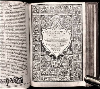
Sold20201612 King James Holy Bible, Genealogy / Map of CanonTHE HOLY BIBLE 1612 This is a very rare 1612 Quartos as there were very few produced to make ready for the 1613 Quartos.See Sold Price
Sold2024Speed Map of Wilshire showing StonehengeSPEED, John (1551-1629). Wilshire [Insets of Salisbury & Stonehenge]. Engraved map with original hand color. London: Speed, 1612. 16 5/8" x 22" sheet.See Sold Price
Sold2021Bev Doolittle "Pray for the Wild Things" SignedArtist: Bev Doolittle Title: Prayer for the Wild Things Medium: Lithograph Limited Edition: 40768/65000 Art Dimensions: 28 H x 21 W inches Framed Dimensions: 40 H x 32 WSee Sold Price
Sold2024Petrus Plancius, Engraved World MapOrbis Terrarum Typus de Integro Multis in Locis Emendatus. Petrus Plancius (1552-1622). Copper-plate engraving with original hand color in full. Amsterdam, 1594. Some stains, creases, folds. Sight sizSee Sold Price
Sold2017America, Rare Early Map of the Americas"America", Rare Early Map of the Americas by Jodocus Hondius (Flemish/Dutch, 1563-1612) for a French edition of Mercator's Atlas, North and South America, hand-colored copper engraved map, published ASee Sold Price
Sold2023Hondius - Map of Virginia and the CarolinasJodocus Hondius (1563-1612), Virginiae Item et Floridae, Amsterdam, circa 1636, text in English verso, engraving on laid paper with hand color, 14-1/8 x 19-3/8 in.; double sided wood frame, 20-1/8 x 2See Sold Price
4 days LeftMichael's GalleryBev Doolittle "Watercolor Study (3 Horses)" Double Signed Original Watercolor$17,400
7 days LeftFleischer's Auctions1755 Map Partie de l'Amerique Septentrionale, qui comprend Le Cours de L'Ohio...$150(2 bids)


![EUROPAE. [Ortelius, Ca. 1584-1612.] Map.: [Ortelius, Abraham] EUROPAE. [C. 1584-1612.] Engraved map by Ortelius based on Jenkinson’s Russia map and Gastaldi’s maps of Africa and Asia, Gerard Mercator’s 1564 map of Britain, a map of Scan](https://p1.liveauctioneers.com/179/82189/42599765_1_x.jpg?height=310&quality=70&version=1447864785)


![Map of Palestine - Woodcut - Lyon, 1535: Tabula Terre Sanctae. Map of Palestine. Woodcut from "Geographia" by Ptolemy Claudius, edited by Michael Servetus. [Lyon, 1535]. Map of Palestine, showing the territories of the Tribes of Israel. The](https://p1.liveauctioneers.com/1980/117218/60259208_1_x.jpg?height=310&quality=70&version=1520155929)


![[MAP] BURGHERS. NEW MAP OF TERRAQEOUS GLOBE. 1700s: Burghers, Michael; Wells, Edward. A NEW MAP OF THE TERRAQUEOUS GLOBE ACCORDING TO THE LATEST DISCOVERIES AND MOST GENERAL DIVISIONS OF IT INTO CONTINENTS AND OCEANS. (Oxford: Edward Wells, circa 1700-](https://p1.liveauctioneers.com/8124/310027/165853622_1_x.jpg?height=310&quality=70&version=1700184289)

![[Maps & Atlases] [Africa] Ortelius, Abraham, Group of 2: [Maps & Atlases] [Africa] Ortelius, AbrahamGroup of 2 MapsBarbariae et Biledulgerid, nova descriptio(Antwerp, ca. 1570-1612). Hand-colored engraving. Coastal map of North Africa and the Mediterranean,](https://p1.liveauctioneers.com/65/180189/90674454_1_x.jpg?height=310&quality=70&version=1601308774)
![Speed Map of Wilshire showing Stonehenge: SPEED, John (1551-1629). Wilshire [Insets of Salisbury & Stonehenge]. Engraved map with original hand color. London: Speed, 1612. 16 5/8" x 22" sheet.](https://p1.liveauctioneers.com/1968/314554/168606352_1_x.jpg?height=310&quality=70&version=1704142666)


