Sold2021NEW DESCRIPTION OF CAROLINA ENGRAVING COLORING"A New Description of Carolina" A double page map of North and South Carolina, engraving with hand coloring, state edition unknown. Plate only: 14.875" x 20.25" Ht: 24.375" Wd: 30.75"See Sold Price
Sold20211861 MAP OF COAST OF SOUTH CAROLINAOriginal 1861 Frank Leslies Illustrated News Coast of South Carolina Wood Engraving with later hand coloring. Professionally framed. In frame measures 28"x31"x1". Weight 9 pds. NO IN HOUSE SHIPPING. PSee Sold Price
Sold2016Print: Lincoln's home in Springfield, IL"The Home of Abraham Lincoln," engraved by John McCrae after Paul Dixon and W. Waud, published by McCrae, New York, 1866; engraving, with very light hand coloring in the foreground, about 12 1/2 X 15See Sold Price
Sold20172 Antique Engraved Maps. "A New Description ofCarolina" hand colored and engraved map by Francis Lamb (fl. 1667 - 1701) and John Speed (1552 - 1629), plate - 14.5" high x 20.25" wide, tear / old repair upper left, center crease, toned paper, framSee Sold Price
Sold2022Map, Johnson's North and South CarolinaMap, Johnson's North and South Carolina(New York: Johnson & Ward, n.d.), steel engraving with color, 1860s, inset vignettes of "Chimney Rocks and French Broad River" plus "Table Mountain," professionaSee Sold Price
Sold2019Engravings, New Land and City on the River(lot of 2) European School (19th century), New Land and City on the River, copperplate engravings with hand coloring, each unsigned, overall (in oval giltwood frame/each): 12.5"h x 14.5"wSee Sold Price
Sold2018Robert Thornton "Large Flowering Sensitive Plant"DESCRIPTION: A Robert Thornton,engraving with mezzotint, aquatint and hand-coloring titled: "Large Flowering Sensitive Plant". Originally painted by Phillipp Reinagle (1749 Ð 1833), and etched and enSee Sold Price
Sold2017Vintage Map, A Perfect Description of the NorthernmostVintage Map, "A Perfect Description of the Northernmost Coastes of England..." engraving with hand-coloring with text verso, overall (with frame): 13.5"h x 21"wSee Sold Price
Sold20231873 Steel Engraving of Smoky MountainsFine steel engraving "The Smoky Mountains. (North Carolina)", printed at New York by Applteon and Co., 1873. On heavy paper, Fine condition, marginal crease. Measures 12.5 x 9.5". Reserve: $30.00 ReseSee Sold Price
Sold20231873 Steel Engraving of Smoky MountainsFine steel engraving "The Smoky Mountains. (North Carolina)", printed at New York by Applteon and Co., 1873. On heavy paper, Fine condition, marginal crease. Measures 12.5 x 9.5". Reserve: $30.00 ShipSee Sold Price
Sold2021A New Map of Texas, Oregon and California"A New Map of Texas, Oregon and California with the Regions Adjoining" by S. Augustus Mitchell, engraving with hand-coloring, 1st edition, published Philadelphia, 1846; framed together with original bSee Sold Price
Sold2021JOHANN HOMANN, MAP OF NEW ENGLAND, 1720Johann Baptist Homann (German, 1664-1724). "Nova Anglia" - circa 1720, engraving with hand coloring. Approx. 19.5" x 23.125" (sheet)See Sold Price
Sold2021C. Mottram Boston Harbor Hand Colored Engraving.C. Mottram Boston Harbor Hand Colored Engraving. C. 1857. Smith Brothers & Co. and Sowle & Wards, publishers (New York and Boston) C. Mottram, engraver, after J.W. Hill. Engraving with hand-coloring oSee Sold Price
Sold2023A John Ruthven Aquatint Engraving of Carolina ParaquetsCarolina Paraquets Plate One Number 228 aquatint engraving on paper singed l.r. original watercolour by John A. Ruthven (1924-2020) 228/500 Engraved by Norma Moran, printed by Andersen-Lamb New York PSee Sold Price
Sold20241876. Echo Lake, New Hampshire. After Jasper Francis Cropsey (American, 1823 – 1900)Echo Lake, New Hampshire. Engraver: Robert Hinshelwood (1812-1875). Artist: Jasper Francis Cropsey. (American, 1823 – 1900). Description: Antique Steel Engraving on wove paper. Modern hand coloured.See Sold Price
Sold2023Audubon Birds of America Gold-Winged Woodpecker Print, Havell EditionJohn J. Audubon (Haiti/New York, 1785-1851) Havell edition "Birds of America" aquatint with engraving and hand coloring in watercolors depicting five birds perched on a blasted tree. Identified in lowSee Sold Price
Sold20201776 Magazine American RevolutionThe January 1776 issue of "The Town and Country Magazine", printed at London for A. Hamilton, 56 pages with one engraving of "Tete-a-Tete". Interesting article on America and description of New BritaiSee Sold Price
Sold201819th C. ENGRAVING S.C. COMMANDERSFramed 19th c. Engraving South Carolina Commanders, War of the Revolution. Including Marion, Pinckney, William Washington, Sumter and Pickens. Engraved by J. Rogers and Published New York, Virtue, EmmSee Sold Price
Sold2020Map- ''Bohemia. Regni Bohemiae descriptioMap- ''Bohemia. Regni Bohemiae descriptio''- engraving with hand-coloring and two cartouches, from an atlas by Abraham Ortelius, ca. 1590, with Latin descriptions. 13 x 20''See Sold Price
Sold2015Dard Hunter Papermaking through 18 centuriesHeading: Author: Hunter, Dard Title: Papermaking Through Eighteen Centuries Place Published: New York Publisher:William Edwin Rudge Date Published: 1930 Description: IllustSee Sold Price
Sold2017Mark Catesby (British, 1679-1749), Two Engravings fromengravings with hand coloring, on laid paper, 18th century, to include "The Turkey Buzzard" and "The Lark," from the first edition of The Natural History of Carolina, Florida and the Bahama Islands, eSee Sold Price
Sold2016(11) 19th C. French Colored Engravings, South AmericanaWestern Europe, Paris, France, various artists listed in body of this description, ca. early to mid 19th century CE. A wonderful ensemble of eleven original steel engravings, all with hand coloring, dSee Sold Price
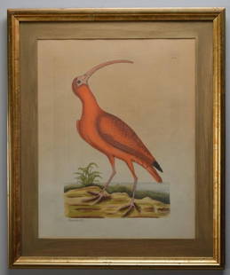
Sold2023Mark Catesby (1683-1749)The Red Curlew, Hand colored engraving from "The Natural History of Carolina, Florida and the Bahamas Islands". Copper plate engraving with later hand-coloring, Plate No. 84 Image: H 16.5 x W 13 incSee Sold Price
Sold2022Bird's-eye view of San Francisco 1850Heading: (California - San Francisco) Author: Title: San Francisco 1850 Place Published: New York Publisher:Henry Bill Date Published: 1850 Description: Lithograph, later hSee Sold Price
6 days LeftTrillium Antique Prints & Rare BooksGreene - Pair of Parrakeet Engravings: New Zealand Parrakeet & Blue Bonnet Parrakeet$25
6 days LeftFichter KunsthandelJ. GAMELIN (1738-1803), Anatomical muscle study, 1779, Copper engraving€400
6 days LeftFichter KunsthandelJ. GAMELIN (1738-1803), Anatomy, foot, hand, chest, 1779, Copper engraving€200
3 days LeftWhite Knight Auction, IncHenri Cartier Bresson, 1947 New York City Manhattan Fire Aftermath$100
3 days LeftWhite Knight Auction, IncHenri Cartier Bresson, 1947 New York City Near Hall Of Records$100
3 days LeftWhite Knight Auction, IncHenri Cartier Bresson, 1946 New York Mother Son Return From War$100
May 12White Knight Auction, IncHenri Cartier Bresson, 1947 New York City Manhattan Fire Aftermath$100
5 hrs LeftRapid Estate Liquidators and Auction GalleryVintage View of Castle Ashby in Northampton Engraved Print$80
5 days LeftJasper52Authentic! David Webb 18k Yellow Gold Diamond Large Colombian Emerald Ring AGL$32,000
4 days LeftHunt and Peck Estate Services, Inc.1903 Lionel Wafer "A New Voyage and Description of the Isthmus of America"$50