Sold2020Sanson Orbis Vetus World Map Paris 1657Nicolas Sanson (1600-1677), "Orbis Vetus, et Orbis Veteris Utraque Continens, Terrarumque Tractus Arcticus, et Antarcticus ex Platone, Thopompo, sive Aeliano, Manilio & c." Paris: P. Mariette, 1657. HSee Sold Price
Sold20211657 Sanson World Map with California as an Island --Title: 1657 Sanson World Map with California as an Island -- Orbis Vetus, et Orbis Veteris Utraque Continens, Terrarumque Tractus Arcticus, et AntarcticusÂ… Cartographer: N Sanson Year / Place: 165See Sold Price
Sold2017Sanson: Antique Map of the Ancient World, 1679Map: Orbis Vetus, et Orbis Veteris Utraque Continens, Terrarumque Tractus Arcticus et Antarctibus Cartographer: Nicholas Sanson Place & Date: Paris / 1679 Size: 21 1/4" x 15" Condition: outline color;See Sold Price
Sold2022Antique Map of the World in Two HemispheresAntique Map of the World in Two Hemispheres - Orbis Vetus, Nicolas Sanson. Overall size: 19 1/2 x 25 1/2 in. Sight size: 15 x 21 in.See Sold Price
Sold2020Framed Antique Map Orbis Vetus, Robert De VaugondyItem/Description: Old print. Map of the world by Robert de Vaugondy from 1752. Orbis vetus in utraque continente : In both the old continent / world map / Vaugondy 1752. Material: Print framed under gSee Sold Price
Sold2023Sanson map of ancient Asia 1650Heading: Author: Sanson, Nicolas Title: Asia Vetus Place Published: Paris Publisher: Date Published: [1650] Description: Copper-engraved map, hand-colored in outline; colored decorSee Sold Price
Sold2019Delamarche, Felix 1829 Map of the Old World"Orbis Antiqui Mappa Nova" Copper Engraved Map Published 1829, Paris for "Atlas de La Geographie..." by Felix Delamarche. Contemporary outline hand colour. Centre fold as published. Paper Size: 18.5 xSee Sold Price
Sold2019Two Maps by Nicolas Sanson (1600-1667, Paris), "LeCoursTwo Maps by Nicolas Sanson (1600-1667, Paris), "LeCours de la Riviere du Rhein. Tous LeDauphin les Estats et Souverainetes," 1692; together with "Gallia Vetus ex C.lulii C aefaris comentarii descripaeSee Sold Price
Sold2022MAP, Holy Land, JanssonHoly Land. Jan Jansson, Tabula Itineraria Patriarcharum Abrahami, Isaaci et Iacobi, from Accuratissima Orbis Antiqui Delineatio…, 1657 (published). Hand Color. A fine decorative map illustrating theSee Sold Price
Sold20231651 Sanson World Map -- Mappe-Monde, ou Carte Generale du Monde; Dessignee en DeuxTitle: 1651 Sanson World Map -- Mappe-Monde, ou Carte Generale du Monde; Dessignee en Deux Plan-Hemispheres… Cartographer: N Sanson Year / Place: 1651, Paris Map Dimension (in.): 13.8 X 20.6 in.See Sold Price
Sold20191763 d'Anville Ancient World Map -- Orbis VeteribusTitle/Content of Map: 1763 d'Anville Ancient World Map -- Orbis Veteribus Notus Auspiciis Serenissimi Principis Ludovici Philippi Aurelianorum Ducis Publici Juris Factus Date: 1763, London CartographeSee Sold Price
Sold20221763 d'Anville Ancient World Map -- Orbis Veteribus Notus Auspiciis Serenissimi Principis LudoviciTitle: 1763 d'Anville Ancient World Map -- Orbis Veteribus Notus Auspiciis Serenissimi Principis Ludovici Philippi Aurelianorum Ducis Publici Juris Factus Cartographer: J d'Anville Year / Place: 1763,See Sold Price
Sold2023Mercator, Rumold (1545-1599) World MapAn engraved double-page double hemispheric world map, "Orbis Terrae Compendiosa Descriptio". Dimensions:Sight is 11 1/4" x 20 3/4", the frame 21" x 29 1/2". Provenance:From a Philadelphia Collection.See Sold Price
Sold2024Nicolaes Van Geelkercken, 1632 world mapNicolaes Van Geelkercken, 1632 world map, Orbis Terrarum Descriptio Duobis Planis Hemisphaeriis Comprehesa, hand-colored engraving, 20th c. restrike, matted and framed under glass, 17"h x 23"w (sight)See Sold Price
Sold2024Map. Portugal. Nicolas SansonPortugal. Nicolas Sanson Hand Colored Map Paris. 1654 17" x 23".See Sold Price
2023Early World Map "Typvs Orbis Terrarvm" Hand ColorDated 1590 near bottom legend box. Hand colored, with red and orange watercolor prominent in the titles. Blue clouds in border. Some slight use of yellow in the boundaries of the map. With signature oSee Sold Price
Sold2017Launay World Map - Typus Orbis Terrarum, 1720Map: Launay World Map - Typus Orbis Terrarum Cartographer: C. Launay Date: ca. 1720 Size: 5 x 8 inches A quite rare, unique and charming double hemisphere map showing very rough approximations for theSee Sold Price
Sold2023French map Paris 1900 World fair first subway line (exposition universelle)Paris map edited for the " exposition internationale de 1900 " by Garniers Freres 6 rue des Saint Peres a Paris . The first subway line opened , during the World's Fair (Exposition Universelle) ,thisSee Sold Price
Sold2018Air France. Large World Map Airways Route Poster.Masse, Jean. Air France. Large World Map Airways Route Poster. Paris: R. Graindorge/Perceval, ca. 1961. Color map of the world detailing the airline's routes. Linen backed. 45 ½ x 81". Small browSee Sold Price
Sold2017Reimer/Kiepert: Antique Map of the Ancient World, 1863Map Ancient World. 'orbis Terrarum Antiquis Notus', 1863 D Reimer / H Kiepert. Berlin. 18 x 14 inches. 1863. Signed Please note that this lot has a confidential reserve. When you leave a bid in advancSee Sold Price
Sold2016[World Map]. Rumold Mercator. Orbis terrae compe[World Map]. Rumold Mercator. Orbis terrae compendiosa descriptio.&See Sold Price
2022Blaeu, Johannes (Netherlands, 1596-1673) "The New World Map" Double Hemisphere World Map C. 1664Nova et Accuratissima Totius Terrarum Orbis Tabula Translated "The New World Map", Hand Colored w/ Elaborately Decorated Spandrels.   Sight View 16" x 21-1/2", Overall View 21" x 25-1/2"See Sold Price
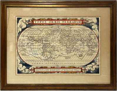
Sold2024Vintage Full Color World Map LithographVintage full colored world map, reading Typvs Orbis Terrarvm with blue and red colors and scrolled motifs with Greco Roman lion and Figural heads and sections in Latin Frame in a tan toned wooden framSee Sold Price
Sold2023Framed Gold Foil World MapNova Totivs Terrarum Orbis Geographica Tabula Gold Foiled World Map in a Gilt Frame. Approx. 25"H x 29"L. Photo has not been examined out of frame. Photos are considered part of the conditionSee Sold Price
May 16Potter & Potter AuctionsBOUCHER, Lucien (1889 – 1971). Provence Breguet 763 / Air F...$300
4 days LeftHunt and Peck Estate Services, Inc.Abraham Ortelius map of Bitiurigum from Theatrum Orbis Terrarum$50
4 days LeftHunt and Peck Estate Services, Inc.Sanson & Jaillot "Le Royaume de Naples Divisé en Douze Provinces"$200
6 days LeftTrillium Antique Prints & Rare BooksBraun & Hogenberg, pub. 1575 - View of Bologna, Italy$100(1 bid)
6 days LeftTrillium Antique Prints & Rare BooksBraun & Hogenberg, pub. 1575 - View of Basel, Switzerland$100
6 days LeftTrillium Antique Prints & Rare BooksBraun & Hogenberg, pub. 1575 - View of Marseille, France$100
6 days LeftTrillium Antique Prints & Rare BooksBraun & Hogenberg, pub. 1575 - View of Limbourg, Belgium$100
6 days LeftTrillium Antique Prints & Rare BooksBraun & Hogenberg, pub. 1575 - Coats of arms of Hannonia, Hennegau in Belgium$100
6 days LeftTrillium Antique Prints & Rare BooksBraun & Hogenberg, pub. 1575 - View of Haarlem, Netherlands$100
May 18Rich Penn AuctionsCountry Store Merkle's Blu-J Brooms Sign, "The largest Broom Factory in the World", Paris, ILL,$100(3 bids)
8 hrs LeftPASHCO RARE - TITI PARISIEN! Swatch with Famous PARIS ART MAP By JACQUES BENOIT! NIB-RARE!$50


![Sanson map of ancient Asia 1650: Heading: Author: Sanson, Nicolas Title: Asia Vetus Place Published: Paris Publisher: Date Published: [1650] Description: Copper-engraved map, hand-colored in outline; colored decor](https://p1.liveauctioneers.com/642/310901/166355383_1_x.jpg?height=310&quality=70&version=1701367957)


![[World Map]. Rumold Mercator. Orbis terrae compe: [World Map]. Rumold Mercator. Orbis terrae compendiosa descriptio.&](https://p1.liveauctioneers.com/906/93415/47683584_1_x.jpg?height=310&quality=70&version=1473203012)


