Sold2017Smith: Antique Railroad Map of the United States, 1855Map: Map of the United States of America, Showing the Rail Roads. Large, Colorful Railroad Map of U.S. 1855 Publication Date: 1855 Authors: HARPER & BROTHERS, SMITH, J. CALVIN / D. MCLELLAN Publisher:See Sold Price
Sold20181855 Smith Map of the MidWest -- Guide through Ohio,Title/Content of Map: 1855 Smith Map of the MidWest -- Guide through Ohio, Michigan, Indiana, Illinois, Missouri, Wisconsin & Iowa Showing the Township Lines of the United States Surveys Date Printed:See Sold Price
Sold2017Smith: Antique Map of the World, 1835Map: 1835 Smith World Map -- A Chart Exhibiting the Actual and Comparative Size of each Country, Nation, or Kingdom; its Population as a Whole and to a Square Mile. Also the Different States of SocietSee Sold Price
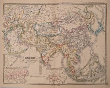
Sold2017Smith: Antique Map of Asia, 1894Map: 1894 Smith Map of Asia [verso] South Central Europe -- Map of Asia Showing its Geopolitical Divisions, and also the Various Routes of Travel between London & India, China & Japan &c. [verso] AustSee Sold Price
Sold2018Smith: Antique Map of South America, 1894Title/Content of Map: 1894 Smith Map of South America [verso] Columbia, Venezuala, Peru, Equador, Argentina -- Map of South America Showing its Political Divisions [verso] Map of U.S. of Columbia VeneSee Sold Price
Sold20221839 Stiles, Sherman and Smith Map of Midwest United States and Kentucky -- Map of the WesternTitle: 1839 Stiles, Sherman and Smith Map of Midwest United States and Kentucky -- Map of the Western States Designed to Accompany Smith's Geography for Schools Cartographer: Stiles, Sherman and SmithSee Sold Price
Sold2017Spruner: Antique Map of Asia, 1855Map: 1855 Spruner Map of Asia -- Asien im Xvten und XVIten Jahrhundrert… Cartographer: K v Spruner Year / Place: 1855 Dimensions: 12.8 x 16.5 in. Condition: Very Good to Excellent. On thick paper, sSee Sold Price
Sold2017Colton: Antique Map of Minnesota, 1855Extremely clean 1855 Colton map of Minnesota. From the 1856 edition of Colton’s Atlas of the World. A virtually spotless map. Lovely full hand-color and impression. Two tiny, light margin spotsSee Sold Price
Sold2017Antique Map: John Smith's Map of VirginiaFramed antique map. John Smith's Map of Virginia. Well-engraved early 19th century reproduction. Discovered and Described by Captain John Smith, 1606. First published in 1612, this was one of the mostSee Sold Price
Sold2017Zatta: Antique Map Lake Michigan / Upper Midwest, 1778Map: Il paese de' Selvaggi Outagamiani, Mascoutensi, Illinesi, e parte delle VI. Nazioni Cartographer: Zatta Place & Date: Venice / 1778 Size: 17 1/2" x 13" Condition: Original color; light overall agSee Sold Price
Sold20181855 Tallis Antique Map of JamaicaTitle/Content of Map: 1855 Tallis Map of Jamaica -- Jamaica Date Printed: 1851 London Cartographer: J Tallis Size: 10 x 13 in. This is a very attractive map of Jamaica. It details and names many villaSee Sold Price
Sold2017Meyer: Antique Map of the U.S. Midwest, 1852Map: Die Staaten von Missouri, Illinois, Indiana, Ohio, Kentucky & Tennessee Cartographer: Bibliographischen Instituts. Place & Date: Hildburghausen / 1852 Size: 7 5/8" x 10 3/4" Condition: original cSee Sold Price
Sold2017Beers: Antique Map of Mid Atlantic Midwest US, 1875Title: 1875 Warner Beers Map of Mid Atlantic and Midwest United States -- County Map of New York, New Jersey, Pennsylvinia, Ohio, Deleware, Maryland, Virginia, West Virginia Cartographer: Warner BeersSee Sold Price
Sold2017Colton: Antique Map of South America, 1855Map: 1855 Colton Map of South America -- South America Cartographer: J Colton Year / Place: 1855, New York Map Dimensions: 15.5 x 11.5 in. Condition: Very good. Nicely colored. Slight toning, mostly iSee Sold Price
Sold2017Colton: Antique Map of Northern Italy, 1855Map: 1855 Colton Map of Northern Italy -- Northern Italy Date Printed: 1855 New York Cartographer: J Colton Size: 13 X 15.5 in. Condition: Very good. Colored. Slight marginal toning. A modest chip inSee Sold Price
Sold2018Colton: Antique Map of Southern Italy, 1855Title/Content of Map: 1855 Colton's Southern Italy -- Southern Italy Kingdom of Naples, I. Sardinia & Malta Date Printed: 1855, New York Cartographer: J Colton Size: 13 X 15.5 in. A very attractive maSee Sold Price
Sold20181855 Colton Antique Map of IndianaTitle/Content of Map: 1855 Colton Map of Indiana -- Indiana Date Printed: 1855, New York Cartographer: J Colton Size: 15.5 x 12.5 in. Nice map of indiana, with color coded counties, showing cities andSee Sold Price
Sold2017Distrunell: Antique Township Map of New York, 1855Map: 1855 Distrunell Township Map of New York -- Map of the State of New York Showing the Boundaries of Counties & Townships, the Location of Cities, Towns and Villages: and the Courses of Rail Roads,See Sold Price
Sold2017Mclellan: Antique Map of Central & Southern Europe 1855Map: Central & Southern Europe Publication Date: 1855 Authors: HARPER & BROTHERS, MCLELLAN, D. Publisher: HARPER & BROTHERS Size: Folio – 15.10 H x 17.10 W Inches To illustrate Harper's Gazetteer. FSee Sold Price
Sold2017Johnston: Antique Map of Ancient Persia & India, 1855Title/Content of Map: 'Persia et India; Inset India Ptolemaei' & according to Ptolemy. Indochina. Date Printed: 1855 Image Size: Approx 24.5 x 31.0cm, 9.75 x 12.25 inches (Large); Please note that thiSee Sold Price
Sold2023"Orbis Romani Pars Occidentalis" Framed Antique Map by Charles Smith c1820s"Orbis Romani Pars Occidentalis" Framed Antique Map by Charles Smith c1820s.See Sold Price
Sold2017Colton: Antique Map of Florida and Florida Keys, 1855Florida (with inset of Florida Keys). J. H. Colton, 1855. From the 1856 second edition of Colton’s Atlas of the World. Rich color with good impression. Clean. Extra light edge toning at side marginsSee Sold Price
Sold2017Perthes: Antique Map of Asia in 15th Century, 1855Map: 1855 Perthes Map of Asia in 15th Century -- Asien gegen die Mitte des Funften Jahrhunderts... Date Printed: 1855, Gotha Cartographer: J Perthes Size: 12.9 x 16.5 in. Condition: Very good-excellenSee Sold Price
Sold2017Perthes: Antique Map of Asia in 13-14th Centuries, 1855Map: 1855 Perthes Map of Asia in the 13th and 14th Centuries -- Asien im XIII-ten & XIV-ten Jahrhundert… Date/Place: 1855, Gotha Cartographer: J Perthes Size: 12.7 x 16 in. Condition: Very good-exceSee Sold Price
Featured4 days LeftJasper52The Bahamas, Cuba & Bermuda "or Summer Islands". THOMSON 1817 old antique map$180
4 days LeftJasper52Descrittione dell' Isola Iamaica…. PORCACCHI. Jamaica 1590 old antique map$200


![Smith: Antique Map of Asia, 1894: Map: 1894 Smith Map of Asia [verso] South Central Europe -- Map of Asia Showing its Geopolitical Divisions, and also the Various Routes of Travel between London & India, China & Japan &c. [verso] Aust](https://p1.liveauctioneers.com/5584/108292/55552449_1_x.jpg?height=310&quality=70&version=1503667951)
![Smith: Antique Map of South America, 1894: Title/Content of Map: 1894 Smith Map of South America [verso] Columbia, Venezuala, Peru, Equador, Argentina -- Map of South America Showing its Political Divisions [verso] Map of U.S. of Columbia Vene](https://p1.liveauctioneers.com/5584/115725/59466841_1_x.jpg?height=310&quality=70&version=1517366277)