Sold2020Tallis map of U.S. with independent TexasHeading: (Texas) Author: Tallis, John Title: United States Place Published: London Publisher: Date Published: [1850] Description: Engraved map, hand-colored in outline; with 7 unSee Sold Price
Sold2018NORTH AMERICA.Texas Republic.Mexican California.RussianTITLE/CONTENT OF MAP: 'NORTH AMERICA, South to Panama.' The Republic of Texas is shown as an independent state as it existed between 1836 and 1845; it shows the US-Mexican border prior to the Mexican-See Sold Price
Sold2020NORTH AMERICA.Texas Republic.Mexican California.RussianTITLE/CONTENT OF MAP: 'NORTH AMERICA, South to Panama.' The Republic of Texas is shown as an independent state as it existed between 1836 and 1845; it shows the US-Mexican border prior to the Mexican-See Sold Price
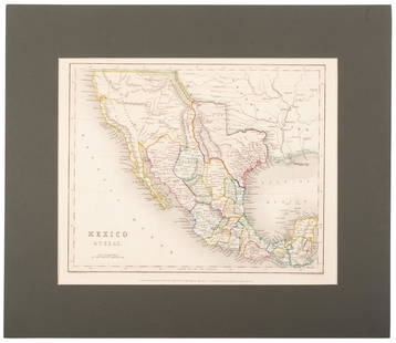
Sold2020Tallis map of Texas, California & Mexico 1851Heading: (Texas) Author: Tallis, John Title: Mexico, California and Texas Place Published: London & New York Publisher: Date Published: [1851] Description: Steel-engraved map, drSee Sold Price
Sold2020Scarce German map of independent Texas 1843Heading: (Texas) Author: Flemming, Carl Title: Texas Place Published: Glogau Publisher: Date Published: 1843 Description: Lithographed map, hand-colored in outline. 39.5x32 cm. (See Sold Price
Sold2018LaPie / Tardieu: Antique Map of US, Texas, Mexico, 1809Map: Mexique Cartographer: P. LaPie / Tardieu Place & Date: Paris / 1809/1812 Size: 11 7/8" x 8 3/4" Condition: outline color; light overall age toning, otherwise beautifully preserved A detailed mapSee Sold Price
Sold2017Meyer: Antique Map of Mexico & Independent Texas, 1845Map: Neueste Karte von Mexico Cartographer: Bibliographischen Instituts. Place & Date: Hildburghausen / 1845 Size: 14 1/8" x 11 3/8" Condition: original outline color; overall age toning; water stainsSee Sold Price
Sold2018Antique Map of Southwestern US & MexicoTitle/Content of Map: Important Southwestern U.S., Texas to CA with Mexico and Guatemala Date Printed: 1843 Cartographer: Based on the work of H.C. Tanner Material/Medium: Paper Size: 17" x 14" Hand cSee Sold Price
Sold2020Mexico with a large independent Texas, c.1845 mapHeading: Author: Gilbert, James Title: Mexico & Texas Place Published: London Publisher:Grattan & Gilbert Date Published: c.1845 Description: Engraved map, hand-colored in outliSee Sold Price
Sold20221850 James Map of US West and Texas -- A New Map of Mexico, California & OregonTitle: 1850 James Map of US West and Texas -- A New Map of Mexico, California & Oregon Cartographer: J A & U P James Year / Place: 1850, Cincinnati Map Dimension (in.): 12.5 X 9.5 in. This is an excelSee Sold Price
Sold2021Early U.S. map shows Texas, Upper Calif. – 1839Title: Early U.S. map shows Texas, Upper Calif. – 1839 Description: Vintage and interesting geography map showing Texas and Upper California at a time when they made up the entire southwestern UniteSee Sold Price
Sold2021Tallis, John (Pub) 1852 Map. Independent TartarySteel Engraved Map with Original Outline Hand Color Published 1852-56 by John Tallis, London for "The Universal Pronouncing Dictionary" by Thomas Wright. Drawn & Engraved by John Rapkin. Centre fold aSee Sold Price
Sold2022(REPUBLIC OF TEXAS.) John M. Niles; and Lorraine T. Pease. A Map of Mexico and the Republic of(REPUBLIC OF TEXAS.) John M. Niles; and Lorraine T. Pease. A Map of Mexico and the Republic of Texas. Hand-colored engraved map of Mexico, an independent Texas, and part of the American southeast. 13&See Sold Price
Sold2017Map of U.S., Mexico, & GuatemalaMap of the U.S. and Texas & Mexico and Guatemala by S. Augustus Mitchell Jr. 1840 Size: 17.5 x 11.75 in Please note that this lot has a confidential reserve. When you leave a bid in advance of the aucSee Sold Price
Sold20204 Maps incl. S. August MitchellIncludes 2 S. August Mitchell maps of the middle states 1852 and 1858, Mitchell map of the U.S. and Texas 1839, and Alaska and part of British America by Mast, Crowell, Kirkpatrick 1905See Sold Price
Sold20231842 Thierry Map of North America -- Amerique SeptentrionaleTitle: 1842 Thierry Map of North America -- Amerique Septentrionale Cartographer: Thierry Year / Place: 1842 Map Dimension (in.): 8.2 X 10.6 in. This is a lovely map of North America. Independent TexaSee Sold Price
Sold20162 Texas Maps inc. Greenleaf, Tallis1st item: Jeremiah Greenleaf, "Texas Compiled from the Latest and Best Authorities," from a rare 1848 reissue of Greenleaf’s 1842 Universal Atlas. Greenleaf's 1842 map of Texas was based upon Burr��See Sold Price
Sold2020With U.S. map showing "maximum" TexasHeading: (Atlas) Author: Olney, J. Title: Olney's School Atlas Place Published: New York Publisher:Pratt, Woodford & Co. Date Published: 1844 Description: With 16 hand-colored coSee Sold Price
Sold2022Map of North America with Independent TexasSteel-engraved map of North America with Texas shown as an independent country, hand-colored in outline. Published by T. Tegg, London, circa 1845. [10" H x 8 1/2" W]. Slightly toned, near fine.See Sold Price
Sold20211864 American History INDIANS Mexico TEXAS Revolution1864 American History INDIANS Mexico TEXAS Revolutionary War US Map Willson Marcus Willson’s “American History” is a mid-19th-century compendium of the history of the United States from its earlSee Sold Price
Sold2020Border between Texas & Mexico 1842Heading: (Texas) Author: U.S. Government Title: Map of the River Sabine from its Mouth on the Gulf of Mexico in the Sea to Logan's Ferry...Shewing the Boundary between the United States and the RepublSee Sold Price
Sold2020Meyer's U.S. with Texas an independent country 1845Heading: (Texas) Author: Meyer, Joseph Title: Nord-Americanische Freistaaten 1845 Nach den besten Quellen entworf. u. gezeich. v. Hauptm. C. Radefeld Place Published: Hildburghausen Publisher:BibliogrSee Sold Price
Sold2021Tallis, John (Pub) 1852 Map. Mexico, California & TexasSteel Engraved Map with Original Outline Hand Color Published 1852-56 by John Tallis, London for "The Universal Pronouncing Dictionary" by Thomas Wright. Drawn & Engraved by John Rapkin. Centre fold aSee Sold Price
Sold2024Tanner's North America independent TexasHeading: (North America) Author: Tanner, Henry Schenck Title: North America Place Published: Philadelphia Publisher: Date Published: 1836-[1845] Description: Engraved map, hand-coloSee Sold Price
Jun 06Akiba GalleriesAntique Mast, Crowell, & Kirkpatrick Map Of Texas, California, & Nevada$25(1 bid)
15 hrs LeftJasper52CENTRAL ASIA. 'Independent Tartary (Turkestan)'. Khiva Bokhara. WELLER 1863 map$20
Jun 23Schilb Antiquarian Rare Books1848 Emory Military Reconnaissance 1ed California MAP Indians Texas New Mexico$2(2 bids)
3 days LeftCain Modern AuctionsDouble Sided U.S. Map by Rand McNally, Illustrated & Equal Area Projection$75
May 30Antiques Online AuctionsVintage Texas 1845 Map Printed in 1986, Compiled by John Davis$60(4 bids)
15 hrs LeftJasper52JAPAN & COREA /Korea. Yedo (Tokyo) King-ki-Tao (Seoul). TALLIS & RAPKIN 1851 map$160
Jun 02Schilb Antiquarian Rare Books1849 TEXAS 1ed Mexican War Porter Annexation Mexico Americana Peace Treaties$88(4 bids)
15 hrs LeftJasper52CENTRAL ASIA.Western Siberia, Khiva Bukhara. Independent Tartary.SDUK 1844 map$20(1 bid)
May 31Freeman's | Hindman[CIVIL WAR]. Archive of items related to Elisha Hunt RHODES (1842-1917), 2nd Rhode Island Volunteer$750
4 days LeftCaff's Collectibles2023 Topps Now Josh Jung 2 HR ALCS Game RC Rookie Texas Rangers #1016$1


![Tallis map of U.S. with independent Texas: Heading: (Texas) Author: Tallis, John Title: United States Place Published: London Publisher: Date Published: [1850] Description: Engraved map, hand-colored in outline; with 7 un](https://p1.liveauctioneers.com/642/174090/87617797_1_x.jpg?height=310&quality=70&version=1595023143)


![Tallis map of Texas, California & Mexico 1851: Heading: (Texas) Author: Tallis, John Title: Mexico, California and Texas Place Published: London & New York Publisher: Date Published: [1851] Description: Steel-engraved map, dr](https://p1.liveauctioneers.com/642/174090/87617796_1_x.jpg?height=310&quality=70&version=1595023143)


![Map of North America with Independent Texas: Steel-engraved map of North America with Texas shown as an independent country, hand-colored in outline. Published by T. Tegg, London, circa 1845. [10" H x 8 1/2" W]. Slightly toned, near fine.](https://p1.liveauctioneers.com/1221/243451/126278661_1_x.jpg?height=310&quality=70&version=1649868014)


![Tanner's North America independent Texas: Heading: (North America) Author: Tanner, Henry Schenck Title: North America Place Published: Philadelphia Publisher: Date Published: 1836-[1845] Description: Engraved map, hand-colo](https://p1.liveauctioneers.com/642/319971/171838592_1_x.jpg?height=310&quality=70&version=1708136548)


![[CIVIL WAR]. Archive of items related to Elisha Hunt RHODES (1842-1917), 2nd Rhode Island Volunteer (1 of 6)](https://p1.liveauctioneers.com/197/329785/177758366_1_x.jpg?height=282&quality=70&version=1715625218)


