Sold2020Scarce German map of independent Texas 1843Heading: (Texas) Author: Flemming, Carl Title: Texas Place Published: Glogau Publisher: Date Published: 1843 Description: Lithographed map, hand-colored in outline. 39.5x32 cm. (See Sold Price
Sold2023German-Language Map of the Americas, 1843German-Language Map of the Americas, 1843 Stieler's Hand-Atlas No. 41 plate: 17 x 12 in., frame: 28 x 23 in. Provenance: A San Antonio, Texas collectionSee Sold Price
Sold2017Antique Important Map of Texas, 1843Title/Content of Map: Texas. Rare and important early Map. Date Printed: 1843 Cartographer: based on the work of H.C. Tanner Material/Medium: Paper Size: 17" x 14" Hand colored engraved Map. From theSee Sold Price
Sold2017Scarce Map of Texas, New Mexico and ArizonaItem: Scarce Map of Texas, New Mexico and Arizona Description: Scarce Map of Texas, New Mexico and Arizona from Wallings's 1868 State Atlas of Ohio Dimensions: 14.25 x 26.25 Please note that this lotSee Sold Price
Sold2020Scarce Cowperthwait, Desilver, Butler map of TexasScarce map of Texas by J.H. Young. “Map of the State of Texas from the Latest Authorities by J. H. Young.” 1850 map from an early 1855 edition of the Cowperthwait, Desilver & Butler New UniverSee Sold Price
Sold2020Scarce hand-colored map of Texas, 1875Attractive and scarce map of Texas with inset map "Western Part of Texas". Exquisite detail with counties painstakingly colored by hand. Interesting map of the growing state developed circa 1875 durinSee Sold Price
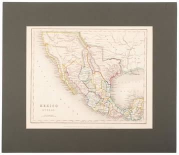
Sold2017Meyer: Antique Map of Mexico & Independent Texas, 1845Map: Neueste Karte von Mexico Cartographer: Bibliographischen Instituts. Place & Date: Hildburghausen / 1845 Size: 14 1/8" x 11 3/8" Condition: original outline color; overall age toning; water stainsSee Sold Price
Sold2019Large & Scarce Bus. Map of Texas, 1892Impressive and highly detailed full color lithographed map from what is considered the best large format American atlas of the latter nineteenth century. Rand McNally’s 1892 Indexed Atlas of the WorSee Sold Price
Sold2020German map of California & Texas 1852Heading: (Texas) Author: Meyer, Joseph Title: Vereinigte Staaten von Nord-America: Californien, Texas und die Territorien New Mexico u. Utah Nach den neuesten Hülfsmitte In gezeich. von J. Grässl. 1See Sold Price
Sold2022Scarce Texas map (eastern part) from Asher & Adams,County map of Eastern Texas extends from Louisiana west to beyond San Antonio and features the railroad system of that time. Features numerous railroads still in their infancy, along with proposed futSee Sold Price
Sold2022Scarce Texas map (western part) from Asher & AdamsLarge double-page map of Western Portion of Texas with inset of extreme western tip of the state. Shows towns, proposed railroad lines and river, including the Colorado River and the Rio Grande. The fSee Sold Price
Sold2020Scarce 1883 map of TexasExtremely scarce early 1883 map is different from the more common later 1883 and 1884 version of Cram’s Texas. The later versions have green county borders with rose hachures for the state outline.See Sold Price
Sold2019Scarce Colton 1855 map of Texas, Johnson/BrowningScarce large map of Texas with 1855 date, but with Johnson & Browning imprint. The Johnson & Browning imprint was found in only the 1859 Colton atlas and 1860 and 1861 Johnson Family atlases. This mapSee Sold Price
Sold2023Scarce 1845 Mitchell map of Texas with Tanner bordersExtremely scarce 1845 C. S. Williams map of the Republic of Texas from a true first edition of Mitchell's 1846 New Universal Atlas, showing the Carey & Hart decorative borders, which are not found inSee Sold Price
Sold2021Scarce Colton 2-page map of Texas, c1884Breathtakingly large, fully hand-colored vintage map of Texas from the very scarce 1890 edition of Colton’s General Atlas. This is the only edition of this atlas that I’ve ever seen—See Sold Price
Sold2020Mexico with a large independent Texas, c.1845 mapHeading: Author: Gilbert, James Title: Mexico & Texas Place Published: London Publisher:Grattan & Gilbert Date Published: c.1845 Description: Engraved map, hand-colored in outliSee Sold Price
Sold2018Scarce 1875 hand-colored map of Texas by HardestyReserve Reduced! Attractive map of Texas and Indian Territory, colored by counties, from the very scarce Jones & Hamilton Historical Illustrated Atlas of the World published 1875 by H. H. Hardest. NicSee Sold Price
Sold2021Scarce 1853 Texas map by Roswell SmithAntique and hard to find antebellum map with full original hand coloring. Engraving on paper. Shows forts, rivers, locations of tribes, towns, counties and topographical features. Eastern Indian TerriSee Sold Price
Sold2020Tallis map of U.S. with independent TexasHeading: (Texas) Author: Tallis, John Title: United States Place Published: London Publisher: Date Published: [1850] Description: Engraved map, hand-colored in outline; with 7 unSee Sold Price
2022Scarce 1833 Finley map of Mexico – fine exampleExtremely scarce map of Mexico depicting Texas territory just three years before it gained its independence. Shows major portion of western America still belonging to Mexico, including New Albion andSee Sold Price
Sold2023Scarce 1833 Finley map of Mexico – fine exampleExtremely scarce map of Mexico depicting Texas territory just three years before it gained its independence. Shows major portion of western America still belonging to Mexico, including New Albion andSee Sold Price
Sold2022(REPUBLIC OF TEXAS.) John M. Niles; and Lorraine T. Pease. A Map of Mexico and the Republic of(REPUBLIC OF TEXAS.) John M. Niles; and Lorraine T. Pease. A Map of Mexico and the Republic of Texas. Hand-colored engraved map of Mexico, an independent Texas, and part of the American southeast. 13&See Sold Price
Sold2017Rand McNally: Map of Texas from Jones & Hamilton AtlasEarly Rand McNally vertical format Texas map from scarce 1876 Jones & Hamilton atlas. Large and uncommon McNally vertical format map of Texas from the scarce 1876 Jones & Hamilton Historical Atlas ofSee Sold Price
Sold20231842 Thierry Map of North America -- Amerique SeptentrionaleTitle: 1842 Thierry Map of North America -- Amerique Septentrionale Cartographer: Thierry Year / Place: 1842 Map Dimension (in.): 8.2 X 10.6 in. This is a lovely map of North America. Independent TexaSee Sold Price
May 16Zikorn Arts & History ObjectsWest Indies, Cape Gracias to Belize 1843 British Admiralty Map$100
May 16Potter & Potter AuctionsSTORM, Mark. Official Texas Brags Map of North America. 194...$200(1 bid)
Jun 02Schilb Antiquarian Rare Books1849 TEXAS 1ed Mexican War Porter Annexation Mexico Americana Peace Treaties$2(2 bids)
May 19The Heritage Gallery at Sayville Antiques, IncHermann Struck L/E 82/100 Etching of Theodor Herzl c. 1920s$50
6 days LeftSchilb Antiquarian Rare Books1859 AFRICA VOYAGES Barth Timbuktu Tripoli SLAVES Illustrated Slavery MAP African$62(4 bids)
May 18Clark Auctions of TexasGerman Regimental Beer Stein, 3. Inf.-Rgt.,,Prinz Carl von Bayern" 6. Comp. Ausburg 1912-14.$130(1 bid)


![Tallis map of U.S. with independent Texas: Heading: (Texas) Author: Tallis, John Title: United States Place Published: London Publisher: Date Published: [1850] Description: Engraved map, hand-colored in outline; with 7 un](https://p1.liveauctioneers.com/642/174090/87617797_1_x.jpg?height=310&quality=70&version=1595023143)


![[CIVIL WAR] 2nd Texas Cav. 1864 ALS (1 of 3)](https://p1.liveauctioneers.com/7226/322253/173251511_1_x.jpg?height=282&quality=70&version=1710004847)


